| GISdevelopment.net ---> AARS ---> ACRS 1991 ---> Land Use |
Analysis of Landuse Change in
Bangkok Coastal Area using Satellite MSS Data
Kiyoshi Torii
Kyoto University, Japan
Kozo Okazaki
Tottori University, Japan
Takashi Hoshi
University of Tsukuba, Japan
Prasert Milintangul
Royal irrigation Dept., Ministry of Agriculture, Thailand
Kyoto University, Japan
Kozo Okazaki
Tottori University, Japan
Takashi Hoshi
University of Tsukuba, Japan
Prasert Milintangul
Royal irrigation Dept., Ministry of Agriculture, Thailand
Abstract
The southeast coastal zone in the suburbs of Bangkok is the most rapidly industrialized district in Thailand in recent year. In the northeast part of Chaophraya Great Plain, a big irrigation project has been implemented for long time. However, the area lying between the above project area and the coat was left almost untouched due to geographical conditions; the land was low and swamped and suffered flood disasters frequently. Now, the state of landuse in this are is rapidly changing as construction of a large scale industrial estate was started a few years ago and shrimp farm in an extended area is replacing the former native fishery.
We analysed landuse change of Bangkok coastal zone using satellite MSS of Landsat, SPOT and MOS-1, and obtained the results, which we discuss in the paper.
1. Introduction
Rapid landuse change in Bangkok coastal area has been studied 1), 2), 3) using Landsat and SPOT MSS data. Recently, MSS image of MESSR boarded on MOS-1 (Marine Observation Satellite-1) was added to the above analysis. New findings in landuse change will be given in the result.
Hoshi developed "SAIAS (Satellite and Airborne Image Analysis System)" program4) with the intention to enlarge processing capacity. Above program was modified and has been executed in Data Processing Center, Kyoto University.
2. Outline of Study Area
Fig. 1 shows outline map of the study area including 3 provinces, Bangkok Metropolis, Samut Prakan and Chachoensao. The are is lying in the southeast part of Chaophraya Great Plain and is enclosed by the Gul of Thailand, Chaophraya river and Bang Pakhong River. In the northern side of the area, a large-scaled irrigation project called "Rangsit Irrigation Project" has been implemented by Thai government for a long time. As Ransit is located upperstream surplus irrigation water introduced from Bhumiphol dam Flows down t the study area, and is discharged to the Gulf of Thailand through natural drainage canal, or klong.
In former times, the above stated broad and plane flow from irrigated area caused flood in Bangkok Metropolis. An artificial drainage canal was constructed from Bangkok to Bang Pakhong river and water pumps of big capacities were installed in poorly drained places to keep Bangkok out of flood disaster.
Route 3 National Highway is running along the coastline of the Gulf of Thailand, and route 34 National Highway connecting Bangkok and Pattaya is running 12-13 km inside it. As these highways were constructed by digging both sides of the planned road and banking up the resulting soil and sand, broad water flows from upstream is stopped by the highway, which is thus playing the role of bank, and is collected into canals along the road. Drained water which was flowing out through many small klongs to the Gulf of Thailand is changed its directions perpendicularly by the highways and is collected into relatively large klongs for flowing down. As for Route 3 National Highway, bridges are constructed only when the road is crossing bit klongs while exits to the gulf are closed completely and the drainage of canal water is carried out by pumping machines. The mouth of klongs is blocked by water gates which have been installed to keep river water separately from sea. Fig. 1 shows the closure of river mouth. As a result, salty water which has flown backward deep into the land at high tide was blocked by this water gate and water in the klongs inside Route 3 National Highway has become fresh. With this water, paddy, field cultivation has become possible using keel wheels or vertical pump even in dry season when irrigation water is scarce. The low swamp are of 2-3 km width extending between Route 3 National Highway and coastline had once been covered by Mangrove and Nipa Palm, among which they carried on primitive fishery and produced salt from seawater by salt field. Since shrimp cultivation was introduced to Thailand a few years ago, salt fields were replaced by shrimp farms, which are extending rapidly to neighbor areas by cutting down Mangrove woods.
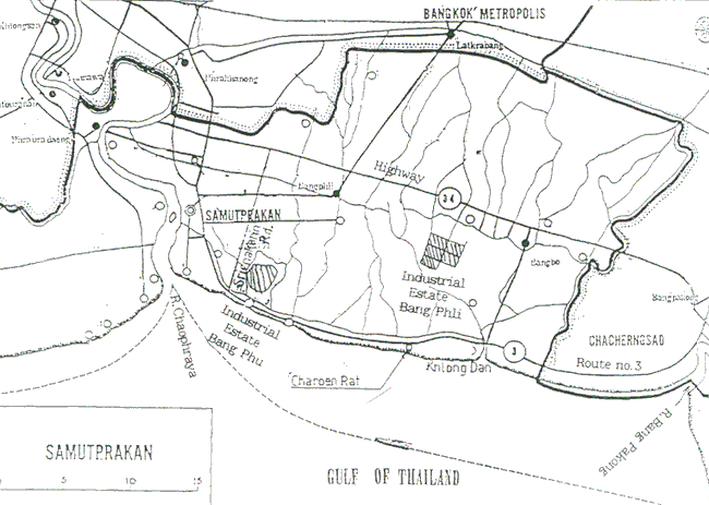
Fig. 1 Outline Map of Study Area (Bangkok Coastal Area)
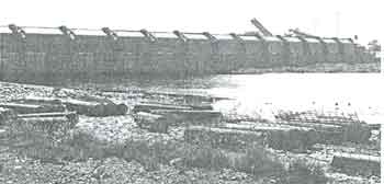
Photo-1 Closing Structure of River Mouth
Thai Government has been constructing large-scaled industrial estates to promote industrialization of their country under the control of IEAT (Industrial Estate Authority of Thailand). The biggest one is Bang Phli situated alt the center of the area shown in Fig. 1 and it occupies more than 700 ha4). In Bang Pu close to Chaophraya River mouth, an industrial estate of more than 450 ha has been developed. In the vicinity of industrial estates, new roads were constructed together with houses along the roads.
3. Outline of Satellite MSS Data
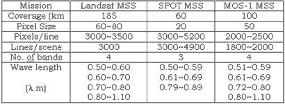
Satellite MSS data used for analyzing the landuse changes in the study are is listed in Table 1. Here, MOS-1 MESSR given in No. 4 is mainly used for analysis and Landsat MSS given in No. 1 for comparison to the previous land cover. Reference to No. 3 SPOT is omitted here as it has ready4). Table-2 shows comparison of image data specifications of these satellite.
| 1 | 2 | 3 | 4 | 5 | |
| Mission | Landsat 2 | Landsat 3 | SPOT | MOS-1 | MOS-1 |
| Band | 4 | 4 | 3 | 4 | 4 |
| Path-10 | 138-51 | 138-50 | 263-323 | 42-101 | 42-101 |
| Date | 976.1.18 | 1979.11.13 | 1986.12.22 | 1989.12.8 | 1990.3.22 |
| Cld (%) | 10 | 30 | 0 | 0 | 20 |
Outline of the system used for the satellite image data processing is shown in Fig. 2.
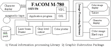
Fig. 2. Outline of satellite image data processing system.
4. Result of Satellite Image Data Processing
fig. 3 shows the result of Landsat No. 2 MSS image data processing recorded on Jan. 18, 1976. One scene of this image data is composed of 3596x2340 pixels and, to make the data correspond to the study area, 1-512 lines were standardized and demonstrated by inputting 651-1674 lines along the vertical direction and 1-1024 lines along the horizontal direction to a computer without thinning out.
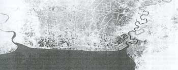
Fig. 3. Study area of Landsat 2 MSS image data recorded on Jan. 18, 1976
In Fig. 4, MOS-1 MESSR Image Data is standardized and demonstrated. This scene is composed of 2520x1800 pixels. The image is photosynthezed by demonstrating 1-1024 lines along the vertical direction and 1-1500 columns along the horizontal direction with- out thinning out. Landmarks for understanding this image are Chaophraya River on the far left, Bang Pakhong River on the far right and the coastal line of the Gulf of Thailand. The artificial drainage canal dug to prevent Bangkok from floods is running straightly from the upper centre of the image to Bang Pakhong River.
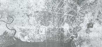
Fig. 4. Study area of MOS-1 MSS image data recorded on Dec. 22, 1979
In detailed observation, Route No. 3 National Highway is running along the costal line and Route No. 34 National Highway from Bangkok to Pataya is running 12-13 km inside it. The site at which Route No. 3 National Highway is bending inward near the centre of the image is Bang Klong Dan, the biggest town along the coastal line. The area lying between the coat and Route No. 3 National Highway was low swamps covered by Mangrove brush woods and nipa palm trees and salt production by salt field was carried out among them. We can see the situation from Fig. 3. In fig. 4, although mangrove belts are still left here and there, most of the woods was converted to the ponds for shrimp cultivation indicating rapid change in landuse. While Shrimp cultivation in Thailand is most active in Samut Sakhon Province located in the wet of the study area, statistical data for the whole Thailand indicates that both the number of shrimp farms and areas increased 3 times in to 10 years starting from 1976 and the output has reached 6 times. The situation is fully comprehended from the satellite image.
5. Landuse Change by Industrial Estates
From latter half on 1980s, amount of investment from various countries to Thailand has been increased rapidly and, in response, construction of large-scaled industrial estates has been promoted under the control of IEAT (Industrial Estate Authority of Thailand) of Thai Government.
The biggest industrial estate is in Bang Phli occupying 714 ha while one of about 600-ha scale has been constructed in Bang Pu near the Chaophrya River mount and one of 465-ha scale in Latkrabang district.
In comparison to the SPOT image in Dec., 1986, the area of Bang Phli industrial estate is expanded about 3 times and enlargement of the are is also observed in Bang Pu.
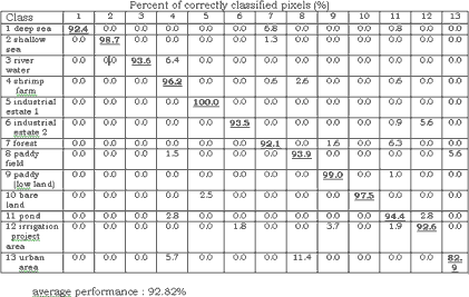
These training fields form a group with spectral features. Their performance is satisfactory from numerical view point. However, errors, in classifying bare field as an industrial estate or urban area as paddy field is conspicuous. Also, river surface, shrimp farms, paddy fields and ponds are the categories hard to be classified. Further, as the study area is located in low land of almost the same height as sea level, land surface is often classified as sea surface being the cause for errors. Thus, some contrivances are needed for connecting these results to classification of land cover.
Conclusion
1. Comparative study f the images obtained by Landsat-2 in 1976, SPOT in 1986 and MOS-1 in 1989 confirmed that industrial estates were contracted in Bang Phli and Bang Pu districts and their areas have been expanding.
2. It is conceivable from MOS-1 image in 1989 that road networks in the vicinity of industrial estates are fully established and residence areas are under development along the roads.
3. It was confirmed that, in the area between Route 3 National Highway and the coastline, salt fields. Mangrove woods and nipa palm woods were replaced by shrimp farms.
It is assumed that this district continues to undergo such changes from now on enlarging industrial estates and expanding residence areas. Furthermore, water environment is also expected to change largely by flowing down of surplus irrigation water from Rangsit Irrigation Project area in the north, closure of Klong river mouth to the Gulf of Thailand so as to prevent backflow of sea water and increased construction of roads acting as banks. By improving classification performance and image processing techniques so as to grasp landuse changes more accurately, we would like to follow up changes in the study area with new image data.
Acknowledgement
Image processing in the study is performed as a part of program development with the permission of Data Processing Centre, Kyoto University. We express our thanks to Mr. H. Terashima in the Centre for his assistance in utilizing image processing system and program consultation. A part of research budget was attributed to Priority Regional Research, Science Research Fund of the Ministry of Education (represented by Takashi Hoshi, Tsukuba University).
Reference
- K. Torii, et. al.: "Approach on Survey of Agricultural Development using SPOT Image Data", Proc. Conference of USPRS, pp. 141-146, May 1989, Tokyo (in Japanese).
- K. Torii, et. al: "Transition of Land Use in Bangkok Coastal Area Using SPOT Image Date", Proc. Of the 11th Asian Congress on Remote Sensing, Kuala Lumpur, pp. G.6. 1-G.6.6, Nov., 1989.
- K. Torri, et. al.: "Analysis on Landuse and Environment Change in Coastal Zone of Bangkok by Satellite Image Data", Proc. Conference of JSPRS, pp. 143-148, May 1991, Tokyo (in Japanese).
- T. Hoshi: "Manual of SAIAS (Satellite and Airborne Image Data Analysis System)", Ver. 1.0, Science Information Processing Center, Univ. of Tsukuba, Nov., 1987 (in Japanese).
- "General Survey of Thai Economics, 1988-1989", Japanese Chamber of Commerce, Bangkok.