| GISdevelopment.net ---> AARS ---> ACRS 1991 ---> Education/Research |
Exploring ILWIS capabilities
for rural land use analysis
Sally Lim
Department of Geography
University Brunei Darussalam
Gadon, 3186, Brunei Darussalam
Department of Geography
University Brunei Darussalam
Gadon, 3186, Brunei Darussalam
Abstract
This paper argues the case for the use of remotely sensed data in human geographic analysis in very specific circumstances. In this case, Brunei represents a small state which faces some difficulties in the gathering of information and data especially of its rural areas. The existing database is scanty and, in some cases out-of-date.
The capabilities of the raster analysis module of ILWIS (Integrated and Land water information system) was explored to provide a platform for explaining the relationship between the land use patterns and the development of the community in Labi, a rural region of Brunei. By (MCalc), it was feasible to integrate tabular and spatial databases and map the complexity of factors that contribute to the patterns of land use of the study area.
The database was derived from the HRV SPOT image, secondary data sources and ground observations. The land cover and land use mapping unit (CUMU) module to analyze the relationships between the land cover, land use and mapping units was based on the work of Wilem van Wijngaarden and Andre Kooiman (1988). The Accuracy was much enhanced by the extensive and clearly defined nature of landuse in the study area.
Introduction
A variety of environmental and human attributes govern the use of land in a development area. Thus, it can be argued that development planning will be more successful if planners have access to up-to-date knowledge of the development region in question, such as changes in the nature and pattern of land use. The research, of which this paper is a part, illustrates a method of extracting and collating valuable information about a rural environment which can contribute towards rural planning and development decisions.
The study of the land use structures of Kampong Labi and is surroundings, a rural area in Brunei, states a case for a gradation towards a pattern of fragmented agricultural land use. To what extent is this process a spontaneous response to the natural environment? Or is there any evidence of the effect of an ad hoc development effort? In what ways have the local community responded to development policy?
One of the difficulties of establishing the trends and patterns of agricultural activities, the degree of land fragmentation and the permanency of land use in this community is the lack of recorded information. Given the peripherality of the rural sector to the national economy of Brunei, institutional records are accordingly infrequently updated. While, in relation to this study, the perceptions of the local community make a major contribution to the analysis, a verification and comparison element is necessary to gain greater insights into the relationships between the community and the use of land. In such an instance, deductions derived from a multispectral image analysis helps to draw out some of the issues and to explain the status and trends of the use of land. This research uses SPOT data on ILWIS to establish the database for analysis.
The Study Area
Although the smallness of Brunei's territory (5,765 Square kilometers) has inhibited agricultural development, the main disincentive to the development of large scale agriculture has been the domination of the economy by the oil and gas industry. Nevertheless, continuous attempts have been made by the Government to generate a series of in situ development in the rural sector as part of the country's food production system. In line with this policy, attention has been given to the southern interior of the country, where there exists a reasonable extent of cultivable land. One such area is Mukim Llabi, one of the eight mukims of the Belait District. It extends southwards form Kg Bt Puan on the bank of the Belait River to Rampayoh and the Brunei - Sarawak border (See Figure 1).
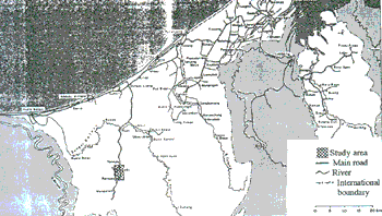
Figure 1 Brunei: The research location (Labi)
This study focuses on the land - based community centered around Kampong Labi. The land area between Kg Labi and Kg Rampayoh approximates to 1,000 hectares (ha) (ULG, 1982:4, estimates only). The main link with the more developed parts of the country is via a surfaced road running northwards to the Muara-Kuala Belait highway. The community of approximately 700 persons is mainly composed of small scale farmers who are engaged in the mixed cultivation of food corps, fruits and vegetables (ULG, 1982: 18, estimates only). Alongside this dominant group are found some long house communities practicing subsistence agriculture.
The CUMU Module in ILWIS
Van Wijngaarden and Kooiman (1988) developed the land cover and land Use Mapping Unit (CUMU) module by exploiting the raster analysis module of ILWIS to assist them in establishing the relationships between terrain mapping units (TMI database) and land cover and landuse (CUMU database). This CUMU module has been adapted for the Labi study.
The first task in the research is to create a database of the land cover, land use and land holdings. All three elements then need to be integrated in a spatial terms to generate the platforms for analysis the relationships between them. Mapping units transposed on the elements provide the spatial dimension of the analytical exercise.
The CUMU database is made up of two parts. The first part represents the inventorial dimension which organizes the data on the land cover and land use types ('cover' and 'use') in tabular format. The second part expresses the relationship between land cover, land use and the mapping units in a spatial dimension. This is achieved by executing the spatial modelling module which is resident in ILWIS.
A classification system is required to organize the inventory of land cover and land use from the multisepctral image . Given the extensive nature of the land use and the moderate rate of land exploitation in the study area, the range of land cover and land use types are clearly defined (see figure 2). Under the circumstance, it was decided to perform the quantitative box classification through the classification module of ILWIS.
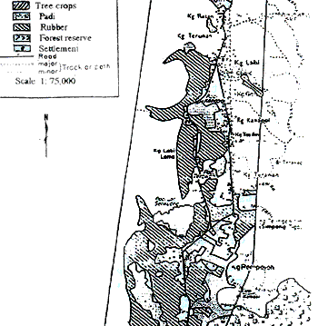
Figure 2 Labi: Land use
The second component of the land cover and land use database is expressed in a CUMU table and a CUMU COMP table. The CUMU table comprises three fields, i.e. the CUMU No, CUMU Co and No Comp while the CUMU COMP table has four fields i.e. the CUMU Comp, Cover Co. Use Co and Comp Pct fields (figure 3).
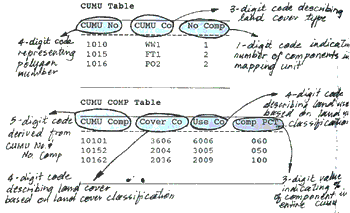
Figure 3 structure of CUMU and CUMU COMP Tables
The CUCMU co describes the cover type of the mapping units. The codes are generated from the classification of land cover for the study area. The following classes of the dominant and sub-dominant cover types were established :
F = primary forest
T = tree crop
S = secondary Forest
N = non-tree crop
G = grass
P = paddi
W = swamp Forest
O = open/fallow land
The CUMU Co provides a useful insight into the degree of heterogeneity of land cover. A sub-dominant code (the second letter) that is similar to the dominant code (the first letter) suggests a homogeneous land cover type whereas a different code suggests a heterogeneous cover type.
The fields of the CUMU COMP table are constructed from digital codes of the land cover and land use classification system. The land cover classes for this study are as follows :
0 = not specified
1 = building and artifacts
2 = fields and plantations
3 = open (semi) natural vegetation
4 = forest
5 = bare land
6 = water
The use Co identified the land use through a four-digit key, based on the following land use classification system :
0 = not specified
1 = settlement and infrastructure
2 = agriculture (annual corps
3 = agriculture (tree crops)
4 = agriculture (non-tree crops)
5 = forestry
6 = conservation and reserves
Having established the CUMUs, the next stage in the analysis is the integration of tables with raster maps and overlaying capabilities of ILWIS. From the overlays of the CUMUs and the terrain mapping units (TMUs), for example the linkages and the relationships between land use, land cover and topography of the region can be derived.
Following the example by Martin (1990) using a raster GIS overlaying technique in geodemography, an overlay constructed from the CUMUs in raster format with population further refines the distribution of the CUMUs value as it would take into account the distribution of population.
In a parallel process, overlays of the CUMUs and the TMUs with the digitized map of private land holdings will establish the proportion of land holdings that are cultivated and the multi-level relationships can be derived.
At this stage of the research, the operation of the CUMUs - population and CUMUs - TMUs - land holdings overlays through ILWIs vector-raster conversion and spatial modeling modules is still experimental and is currently being undertaken.
Conclusion
This paper is part of a pilot study project to establish a case for the use of the Remote Sensing methodology to assist in a geographical analysis of rural development in Brunei where existing institutional records are scanty and incomplete.
By exploiting the raster analysis module of ILWIS, a reasonable database has been extracted from the HRV SPOT image covering the study area. This database, in combination with information obtained from secondary sources, provides a platform from which is derived explanations about the relationship between the patterns and trends of land use and the natural and human environment.
Such kinds of geographical analyses are particularly useful for identifying development projects.
References
- Brunei Government, Brunei Agricultural and Forestry Development Study, Final Report, The Labi Area Report, ULG Consultant Ltd., Volume 1,1982.
- Franz J.C., The Sultanate of Brunei: Oil Wealth and problems of development, Wirtschafts-und Social geographisches Institute der Freiderich-Alexander - Universitaet Nuernberg, 1980
- Martin, D., Understanding Socio-economic geography from the analysis of surface form, paper presented at the second and European Conference on Geographic Information Systems, Brussels, 1991.
- Van Wijngaarden, W. an Kooiman, A., CUMU: the land cover and land use database, in ITC Journal, Volume 1, 1988.