| GISdevelopment.net ---> AARS ---> ACRS 1991 ---> Education/Research |
The impact of technological
change on educational programs: How will we cope?
Norm Edwards,Greg Ellis
Department of Land Information
Royal Melbourne Institute of Technology
GPO Box 2476V, Melbourne, Australia
Department of Land Information
Royal Melbourne Institute of Technology
GPO Box 2476V, Melbourne, Australia
Abstract
As technological change impacts upon many aspects of our lives, land information and related areas are being affected drastically in many ways.
Remote sensing , until recently an emerging technology, is maturing and being utilized in a diverse range of applications. Nowadays, for example, the integration of remote sensing with other technologies, such as the Global Positioning System (GPS) and Geographic Information Systems (GIS), is significant in many mapping related applications.
Changes are also occurring in other aspects of the land information industry. Issues such as the blurring of professional boundaries and the increasing need to diversify both skills and levels of knowledge add to the total impact. For academic institutions, these diverse changes affect directly the philosophy, the content and the methodology of the educational programs that are offered.
This paper will investigate and discuss some of these changes and the type and nature of their effects. It will outline how courses at the Royal Melbourne Institute of Technology (RMIT) are being modified in an attempt to maintain them as relevant, effective and desirable programs for the land information profession and for the community as a whole.
Introduction
The impact of the rapidly changing and developing face of technology on the educational process is quite dramatic. It would seem that almost every day new challenges and changes occur, and for the educator trying to provide relevant and appropriate courses this is a nightmare.
One of the challenges today is to provide some sort of relevant structure and philosophical basis to something that is moving quickly away from he traditional . Change is all around us. But for traditionally conservative professions which are used to convention and stability, the effects of the types of change which we are undergoing are quite traumatic. To cope with the change and to develop educational programs which are acceptable and appropriate is the challenge of the 1990’s for all educators.
To educators in the disciplines of surveying and mapping, the readily identifiable problem is to decide upon the appropriate mechanisms, structure and content for educational programs to produce graduates who are competent, relevant and able to absorb and develop as changes continue to occur in the future.
Presented at the 12th Asian Conference on Remote Sensing, Singapore, 30 October – 5 November 1991.
The considerations
In addressing this problem are a number of factors which require consideration.
- The surveying and mapping professions have been conservative and traditional by nature, and as a consequence are generally uncomfortable with change. Significant and/or radical changes may even elicit and response which chooses to ignore the problem in its entirety.
- In Australia there is an increasing advocacy of the interest in multidisciplinary and generalist approaches to project development in areas relevant to the land-related disciplines. There has certainly been a shift away from the traditional and discipline – oriented approaches to surveying and mapping.
- This has resulted in non-categorical job descriptions. For example, in the past a surveying position would be advertised in such a way that only qualified surveyors would be eligible to apply, and the employer (usually also a surveyor ) would chose appropriately from a group of applicants qualified as surveyors. Nowadays it is increasingly the case that jobs are described in more generalist terms and such the certain skills and knowledge are required. No longer are such jobs for surveyors only. The consequence of this is that graduates from surveying and mapping courses must compete, in the market place, with a range of other graduates.
- This new and emerging areas which are relevant to land-related activities are not being identified with particular professional groups. Many groups have interest in and involvement with Geographic Information System (GIS), remote sensing and the Global Positioning System (GPS), for example. There is ample indication, however, that surveyors and cartographers are well – placed to take on the burden required to be shouldered by Land Information professionals within society {Edwards and Cartwright, 1989}.
- Changing technology and resulting work practices have also impacted upon the surveying and mapping professions. If courses are to remain relevant, then new areas of study need to be incorporated. However, it is not possible to keep adding material endlessly; at some stage course need to be looked at with the view to removing material which has become obsolete or irrelevant.
- For many surveyors, the term surveying is synonymous with cadastral surveying. This implies a legally protected niche which the surveyor will attempt to retain as a financially rewarding haven. The effect of this possibly false perception means that many in the profession do not see the urgency or need to become involved in the emerging areas of potential employment.
- The problem of defining the roles of the technician (or technologist ) and the professional is also becoming difficult, with technological advanced enabling many tasks which were once only able to be carried out by the professional to be undertaken by the sub-professional.
- Professional identity needs also to be addressed. If a course undertaken by students is altered in significant ways, when is the graduate no longer a surveyor or a cartographer? And when do the boundaries between these two prof.- essions blur sufficiently to be ignored? The difficulty here lies in adopting an acceptable definition for the surveyor or cartographer – a definition which may vary significantly within various groups across the profession
- Advances in technology quickly render hardware and software obsolete. Hardware and software typically have maintenance contracts which provide problem-solving facilities and upgrades. With financial resource limited it is not possible for academic institutions to purchase and subsequently replace or upgrade equipment from recurrent funding sources. If a Department has a variety of hardware and software then the additive amount required to satisfy these contracts can be quite prohibitive.
- Changing the nature an content of courses does take time. Typically, a major course amendment may take over a year to pass through the approval system. Thus if the changes take one year to develop within the Department, one year to be approved, and if the course is four years in duration, then the first graduates passing through the restructured program will be six years downstream from the commencement of the notion of change, in accordance with the findings of Leahy and Williamson { 1991} If the graduates take up to four years to be in positions to use their training in a significant ways, then lead time for change is even longer. The consequence of this is that courses would be expected always to be catching up, but in fact they would always be behind the change which is occurring.
- Change also severely impacts on the academics employed within educational institutions. The ability to accommodate and be comfortable with change is quite variable. A competent and hardworking academic in an areas seen to be no longer relevant may have great difficulty accepting the demise of his or her specialist field, and may not readily accept the need to move into a new area of interest. The ephemeral nature of modern times indicates that during a working lifetime there may occur the need to be retrained several times. Younger academics generally accept this notion, older people may not.
- As financial constraints are applied, academic institutions are forced to seek more funds from non-recurrent sources. Thus the spectrum of activities expected of academics is much wider than in past times. They are now expected to teach and administer course at undergraduate and postgraduate level, supervise higher degree students, run short course programs, carry out research and publish the results, undertake appropriate consultancies, and be active professionally. The need to be more entrepreneurial is certainly becoming important within academic institutions in Australia.
Having defined the problem and expanded upon some of the difficulties, restrictions and challenges, let us now consider what may be an appropriate course of action from an academic surveying and mapping department to adopt in order to survive, and indeed prosper, in the coming decade.
At the Royal Melbourne Institute of Technology (RMIT), undergraduate courses in Surveying and/or Cartography have been offered for over thirty-five years. During the nineteen-seventies, programs leading to Associate ship Diploma qualifications were replaced by Degree courses in both disciplines, to be taken over three years of full-time study, or a part – time equivalent.
These courses, designated Bachelor of Applied Science in Surveying or Cartography, were designed as broad educational platforms to enable graduates in the respective disciplines to “meet the unpredictable challenges of the eighties” {RMIT, 1971}, and to play major roles in the future of the surveying and mapping industry.
Since this time both courses have produced many graduates, and these have been accepted both nationally and internationally as professionals who fulfill these lofty aims. During this period, also, many modifications have been made to both the structures and content of the courses in order to reflect the development of new technologies and techniques and the changes in direction experienced by the surveying and cartography professions.
However, to help us to cope adequately with the previously outlined challenges and considerations accompanying our passage into the nineties and beyond, a radical new undergraduate course has been adopted, and appropriate new postgraduate programs have been, and are being , developed. Attitudes towards non-traditional teaching and other activities in the RMIT Department of Land Information have also undergone significant change
The Undergraduate Program
The new undergraduate program is the Bachelor of Land Information - a four year full – time degree course with a major stream in either surveying or Cartography. The extra year has been added, over and above the successful three year Bachelor of Applied Science courses, to allow both the addition of new and diverse material and a greater assimilation of course content by students. A further advantage of the extended duration is the acceptance of some project work done in later years of the course by the surveyors Board of Victoria, the body currently responsible for registration of surveyors in that State.
Common studies
Material in the course has been gathered in discrete study areas. These areas, and the percentage of the course devoted to them in each of the four years, are shown in Table 1.
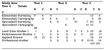
Table 1. Percentages of course study areas for each year (s: Surveying stream; C: Cartography stream )
In addition, the structure of each of the four years has been designed to present a body of common material to all participants in the course, supplemented by specialized studies in either surveying or cartography, depending on the major stream selected. The amount of common material varies, from nearly 70% in Year 1 to a minimum of about 44% in Year 3. Identification of such an amount of knowledge and skill which is needed by both professional surveyors and cartographers reflects the growing lack of distinction in the boundaries between these disciplines.
Many of the new, emerging areas relevant to land related activities are covered in this common portion of the course, and are in many instances augmented by further material and applications in the specialized streams. Studies in the “newer” fields of, for instance, land and geographic information systems, remote sensing, the environment and computer science, are included under this heading and comprise over 26% of the total program. The inclusion of this new, “non-categorical” material ensures the value of both surveying and cartographic graduates as members of multi-disciplinary teams and enables them to compete on a better footing in the job market place. Furthermore, the ability to demonstrate a solid grasp of the essentials in these fields will strength the claim of our profession to the right to influence the directions of future development.
Streamed studies
For both surveying and cartography students , approximately 56% of their course is devoted to specialized studies in the chosen stream, or studies in relevant areas of applied science ( such as mathematics, physics, statistics and so on).
These specialized studies include full coverage of traditional area of the relevant discipline, and, particularly in later years of the course, detailed treatment is given to the more modern technologies and techniques – for surveyors: such topics as total station surveying and satellite positioning; and for cartographers: computer – aided mapping and desk – top publishing.
Practical orientation
As with the earlier degree courses, the Bachelor of Land Information continues to boast a high level of practical content – as much as 32% of the student’s least in part, in such a “hands-on” mode include all aspects of survey fieldwork and associated computations, cartographic drafting and reprographics, photogrammetry and remote sensing, land and geographic information systems and computer-aided mapping. Surveying or mapping camps are held in three years of the surveying stream and in two years of the cartography stream. Such practical emphasis usually generates a sizeable amount of project work. It constitutes an important part of the learning process for all students, and plays a large role in ensuring that RMIT surveying and Cartography graduates are readily accepted into industry.
During the final year of the course all students are required to complete a major community or client based practical project related to their mainstream studies. Work on this project comprises nearly a quarter of the final year program, and emphasis is placed on student’s ability to perform a complete survey or mapping task. Recognition of work done in this project is allowed for the purposes of registration by the surveyors Board.
Honours program
Students who have achieved an excellent rate of academic progress by the end of Year 3 of the course are able to embark upon a program during their final year which requires a well identified higher standard of achievement in most subjects studied as well as the production of a dissertation based on investigational research. This program has been devised to enable ready articulation between tertiary and post – tertiary education. It is designed to prepare students for postgraduate study in one of the areas related to surveying, cartography or land data management, and may result in the award of the degree of Bachelor of Land Information with Honours.
The Postgraduate Program
In addition to the undergraduate degree the Department of Land Information offers several alternatives for postgraduate study. These include its Graduate Diploma in Land Data Management, a Master of Land Data Management by coursework, and higher degree programs by research at both Master and Doctoral level. This aspect of the Department’s activities has been greatly strengthened in recent years to serve the perceived current and future demands of industry. Since 1988 the number of postgraduate students has more than doubled.
Land Data Management
The Graduate Diploma in Land Data Management replaced the former Graduate Diploma in Automated Cartography towards the end of the nineteen-eighties, and was designed to serve the requirements of professionals in the private and government communities who faced an increasing need to deal with land-related data. It aims to educate graduate consultants with the ability to be actively involved in the capture, storage, manipulation and presentation of land data, and it is directed towards professionals such as surveyors, cartographers, engineers, foresters, planners, environmental and computer scientists who are engaged at all levels of the management of land data.
The course can be completed in one year of full time study amounting to 16 hours per week, or by equivalent part time study, after the attainment of a suitable first degree. It is divided into core and elective subjects in equal ratio. The core subjects focus on land resource software techniques and applications and include an investigation project related closely to the student’s vocational interests. The electric subjects permit either specialization in one of the areas of environmental studies, land and geographic information systems , remote sensing, satellite positioning or computer science, or to select a broader program which encompasses studies in two or more of these areas.
An alternative and extension to the Graduate Diploma is the Master of Land Data Management program by coursework, which differs principally in the extent of the research of investigational component and the requirement that studies in depth are required in at least one of the elective subject groups. This program can be taken over one and a half years, or three academic semesters, if undertaken full time. One full time year of extra study after completion of the Graduate Diploma will gain also the Master qualification.
Research Programs
Over twenty research topics are being pursued by higher degree candidates in the Department in the Department of Land Information at the present time. These cover a wide range of aspects of surveying, cartography and land information. Four programs related to development of the Global Positioning System, an area in which the RMIT has achieved a high level of recognition, are currently underway. Five programs; relate to remote sensing applications and are carried out under the guidance of the RMIT Centre for Remote Sensing, which is hosted by the Department. A further five programs are in the areas of land and geographic information systems, three of these being concerned with their use at local government level. The remaining programms are in the more traditional fields. Many of these candidates are supported in their programs by industry.
Continuing Professional Development
As an adjunct to the award courses and programs highlighted, the Department also offers an array of short courses and workshops sensitive to the needs of industry, These range from introductory programms on recently developed survey computing software applications to a sophisticated series of courses on the principles and use of geographic information systems; from training sessions in the use of Global Positioning System instrumentation to courses on the theory and application or Remote Sensing’; from workshops designed to introduce professionals to tomorrow’s computing tools to seminars for increasing industry awareness of current direction in research and development.
Attitudes for the Future
The Department of Land Information at RMIT has altered its formal educational programs over the last few years to move in the direction indicated by consideration of recent technological changes. Research and teaching are combined with consultancy work these days to “make ends meet”, and this has led to stronger relationships with industry and government, and stronger cross-institutional links. Training consultancies for return assistance “in kind”, rather than for monetary gain, are also gaining prominence in our activities. These attitudes and activities lead directly to improved and enhanced educational programs, and to the production of graduate professionals at all levels who are highly suited to the requirements of the community as dictated by technological change in the coming decade.
References
Edwards N F and Cartwright W E, 1989, “Computer usage in the education of professionals in Victoria’s land information industry”, proceeding 20th Higher Education Computer Conference of the Australian Colleges of Advanced Education, Bendigo, Australia, 25-27 September, 61-78.
Leahy F and Williamson I P, 1990, “Educating surveyors for the next century: Issues and strategies”, proceedings 33rd Australian surveyors Congress, Albury-Wodonga, Australia, 6- 10 April, Paper 8.
RMIT, 1971, “A proposal for a course in surveying for the Degree of Bachelor of Applied Science (Surveying ) of the Victoria Institute of Colleges”, Royal Melbourne Institute of Technology, Melbourne, Australia.