| GISdevelopment.net ---> AARS ---> ACRS 1991 ---> Education/Research |
A trilateral cooperation for
the development of northeastern Brazil, II
Klaus A.
Ulbricht
DLR-Optoelektronik, 8031 Oberpfaffenhofen, Germany
Harendra S. Teotia
Univ. Federal de Paraiba, CCT-UFPB, 58100 Campina Grande, Brazil
Daniel L. Civco,William C. Kennard
University of Connecticut, Storrs, CT, 06269, U.S.A.
DLR-Optoelektronik, 8031 Oberpfaffenhofen, Germany
Harendra S. Teotia
Univ. Federal de Paraiba, CCT-UFPB, 58100 Campina Grande, Brazil
Daniel L. Civco,William C. Kennard
University of Connecticut, Storrs, CT, 06269, U.S.A.
Abstract:
For a number of years there has been cooperation between the ‘Centro de Ciencias Tecnicas’ (CCT) of the ‘Universidade Federal do Paraiba’ (UFPB), Brazil, the ‘Institute fur Optoelektronik’ of the German Aerospace Research Establishment (DLR-OE), Germany, and the College of Agriculture and Natural Resources of the University of Connecticut (UCONN), USA, aiming at the improvement of the undeveloped and underdeveloped parts of the North-East of Brazil with help of remote sensing. Satellite imagery on computer compatible tapes has been evaluated with the help of a sophisticated laser beam recorder at DLR in Oberpfaffenhofen, Germany, to produce false colour images and single band evaluations from LANDSAT TM and SPOT satellites. Optical evaluation led to maps giving drainage charts for land irrigability, as well as morphophysical characteristics of the soil, geological landscape characteristics and major soil classes and soil association. Detailed digital image processing at the Laboratory for Remote Sensing of the University of Connecticut resulted in maps of land use and land cover classifications, soil associations, slope classes, soil mapping units, an erosion model for a particular area, and agro technical limitations.
Several papers have been published at the more important earth reconnaissance conferences (1-7) and lectures and reports have been addressed to students and interested persons. A proposal for the installation of a remote sensing laboratory has been referred to a Brazilian University (8), and projects for training and education of students of higher academic level in Brazil, coupled with on the job training, have been submitted to funding organizations (9, 10) taking advantage of the experience of the German remote sensing center at DLR-Oberpfaffenhofen or the dedicated image processing at UCONN, and taking advantage of the more progressed education possibilities in Germany (Berlin) compared to Brazil. Last, but not least, limited financial sources for the pursuit of the work, including the purchase of tapes, photographic material, trips to Brazil, Germany, and the US, for information exchange and lectures, as well as training and teaching, had to be secured. Particular results of the cooperation, gathered from SPOT computer compatible tapes, are presented.
Objectives
Main purpose of the cooperation is the development of the Northeast of Brazil, to be acquired by
- training and education of Brazilian scientist (remote sensing, image processing, geographical information systems for use in geology/mineral exploration, regional/urban planning, soil/land management, ecological studies).
- the production of different kinds of thematic maps (to aid the authorities in planning and management processes), and
- the use of modern technology and technology transfer.
Investigated Area
The research area in the northeast of Brazil was selected according to development necessity, personal experience, i.e. available ground truth, and coverage by LANDSAT and SPOT satellite. Computer compatible tapes (CCT) of cloudfree imagery investigated were:
| Nomenclature | Acquisition date | Center coordinates | |
| LANDSATE (WRS 215-06) | June 17, 1984 | S 07015’02” | W 036048’48” |
| SPOT (728/364) | May 10, 1987 | S 07000’ | W 036055’ |
| SPOT (728/364) | Febr. 24, 1991 | S 07001’ | W 037002’ |
As well as CCT’s of related areas.
Additional information sources for the investigation were aerial photography and topographic maps. Photographic enlargements of false colour composites, real colour composites, and b/w prints of single bands were used for the optical interpretation.
Particular digital investigations, correlated with ground truth acquisition, were centered around the Santa Luzia area in the state of Paraiba, as well as the Picos area in the state of Piaui.
Methodology
Optical interpretations were done using b/w recordings as well as false colour composites of LANDSAT TM and SPOT satellite spectral bands by DLR’s FIRE laser beam recorder. An enlarged paper print was placed on a light table and boundaries of homogeneous area were drawn in by hand. The mapping units this recorded were identified by.
- comparison with published technical reports and maps,
- comparison with a generalized interpretation key (Teotia 1981)and
- vertification with personal experience and collected ground truth.
A hybridized unsupervised-supervised classification approach was used for analysis of land use/cover and other earth resources information, and modified/corrected interactively. The classification approach was modeled after the USGS-System for use with remote sensing data, modified to account for locate conditions within the study area.
Data in a later stage of the investigations were geometrically corrected and georeferenced to Universal Transform Mercator System.
Auxiliary Means
Information sources for the investigation, as well as instrumentation used in pursuit of the work, were:
The land capability classification (12)
Brazilian approximations (1979, 1981)
Soil approximations of SUDENE 1972 (13)
EMBRAPA Empresa Brasileira de Pesquisa Agropequaria
Soil taxonomy of 1975 (14)
Atlas Geographical do Estado da Paraiba of 1985 (15)
Land use-cover acc. To J.R. Anderson et al. 1976 (11), and
Computer compatible tapes of LANDSAT and SPOT satellites,
Aerial photography,
Topographic maps,
Soil survey maps at the small scale of Brazilian and FAO/UNDP systems,
Topographic maps of SUDENE (Superintendencia de Desenvolvimento de Nordeste)
Ground truth aquired at the UFPB in Paraiba, Brazil, and
The FIRE Laser Beam Recorder at DLR-Oberpfaffenhofen, Germany
the ERDAS image processing system at the University of Connecticut, Storrs, USA the geographical information system correlated with ERDAS at UCONN, USA.


Results/Optical Interpretation
Because of limited space, only few examples of optically evaluated satellite imagery are presented (SPOT 728/364, S 07000’, W 36055’)
- Drainage chart with synoptic presentation of surface water, streams and their tributaries, ponds and lakes.,
- Land use and land classes (for interpretation key see (4)) Soil mapping units (see (4))
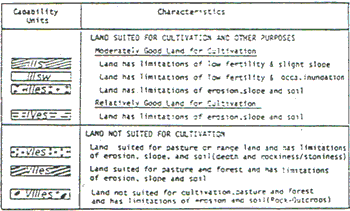
- Land capability units, land for cultivation suited or not (for details see (4)).
Parts of SPOT scenes were investigated by digital techniques. Training areas for supervised maximum likelihood classification were selected by interactive correlation (recoding) together with map- and ground truth verification.
The classification served to identify land categories at different levels. Maximum likelihood classification could identify general land categories at level I, more detailed categories at level II, and very detailed (but less accurate) categories at level III (4, 5, 14).
Depending (partially) on uniform training areas (to be controlled by computer printouts of grey values), results of maximum likelihood classification arrived at an overall classification accuracy of better than 90 %. With the help of UCONN’s ERDAS image processing system, maps of land use/cover, soil, land capability, and soil slope were prepared, trying to support local authorities in planning processes and decisions, if necessary and wanted. The production of maps was done using US Geological Survey (USGS) and US Department of Agriculture (USDA) classification systems. Main areas ‘investigated digitally’ were the Santa Luzia area in the state of Praiba (6), and the region of Picos in the state if Piaui (7).
Furthermore, a tentative geographic information system has been developed, and an erosion model for the Santa Luzia municipality been produced with its help (3).
These pilot results are the foundation for a development project for the northeast of Brazil, submitted to the proper authorities (9), comprising the training and working capacities of Brazilian scientists on remote sensing investigations of the northeast of Brazil for its development.
Bibliography
- Teotia, H.S., Ulbricht, K.A. (1985) Evaluation of LANDSATE Thematic Mapper Date of Generalized Soil, Land Use and Land Cover Classification in the Semi-Arid Part of the Sate of Paraiba, Brazil, in ‘Advanced Technology for Monitoring and Processing Global and Environmental Data’, London, UK, Sept. 10-12, proc., pp. 130-140.
- Ulbricht, K.A. Teotia, H.S. (1986) Use of LANDSAT Thematic Mapper Imagery for soil and Landsue Investigations in Paraiba, Brazil, XXth ERIM-Conference, Dec. 4-10, Nairobi, Kenya, proc., pp. 1059 – 1070.
- Kennard, W.C., Teotia, H.S., Civco, D.L. (1988) The Role of an Automated GIS in the Development and Management of Renewable Natural Resources of Northeastern Brazil, 16th ISPRS-Congress, Kyoto, Japan, July 1 – 10, proc., pp. VII 220 – 231.
- Teotia, H.S. Kennard, W.L., Civco, D.L. (1988) Optical and Digital Interpretation of SPOT Imagery for Land Resources Planning and Management in Northeastern Brazil, 16th ISPRS-Congress, Kyoto, Japan July 1 -10, proc., pp. VII 799 – 821.
- Kennard, W.C., Civco, D.L., Teotia, H.S., Ulbricht, K.A. (1989) A Trilateral Cooperative Effort for the Development of Northeastern Brazil, 9th EARSeL-Symposium, Helsinki, Finland, June 27 – July 1, proc., pp. 223 – 227.
- Teotia, H.S., Kennard, W.L., Civco, D.L., Ulbricht, K.A. (1990) Digital Image processing and GIS Application for Natural Resources Monitoring and Evaluation in Northeastern Brazil, ISPRS-Comm. VII Midterm Convention, Victoria, Sept. 17 – 21, proc. To be publ.
- Teotia, H.S., Ulbricht, K.A., Civco, D.L., Kennard, W.L. (1991) Utilization of SPOT-Data for Land Use/Cover Mapping and Soil/Land Classification in the Piaui State of Northeastern Brazil, XXIVth ERIM-Conference, Rio de Janeiro, Brazil, May 27-31, proc. To be publ.
- Kennard, W.C., Civco, DL.L., Teotia, H.S., Ulbricht, K.A. (1989), Establishment of an Aerial Photointerpretation and Remote Sensing Laboratory for Natural Resources Studies at the University of Piaui.
- Teotia, H.S., (1990) Installacao de um Programa de Treinamento, Educacao e Applicacoes de Sensoriamento Remoto Avancada e SIG Pra Exploracao em Geologia/Mineracao, Planejamento Regional/Urbano, Classficacao de Uso da Terra e Cobertura Vegetal, e Estudo do Meio Ambiente Ecologia, Research project submitted to ‘Agencia Brasileira de Cooperation’.
- Teotia, H.S. (1990), Sensoriamento Remoto Avanmcada (Interpretacao Automatica) em Desenvolvimento e Planejamento de Uso da Terra Sobre a a Regiao da Serra do Teixeira no Estado da Paraiba, Research project submitted to Funepe.
- Anderson, J.R., Hardy, E.E., Roach, J.T., Witmer, P.E. (1976) A Land Use and Land Cover Classification system for Use with Remote Sensing Data, US Geological Survey, Reston, Virginia, USA, Professional Paper 964, pp. 28, Illus.
- USDA (1966), Land Capability Classification. Soil Conservation Service. Agriculture Handbook No. 210, Wash. DC, USA, pp. 21.
- SUDENE (1972) Levantamento Exploratorio-Reconhecimento de Solos do Estado do Paraiba, Boletim Tecnico No. 15. Serie Pedologica No. 8, Recife, Pernambuco, Brazil, pp. 670.
- USDA (1975), Soil Taxonomy, A Basic System of Soil Classification for Making and Interpreting Soil Surveys, Soil Survey Staff, US Soil Conservation Service, InAgriculute Handbook No. 436.
- Secretaria de Educacao, Governo do Estado da Paraiba, UFPB (1985) Joao Pessoa, Atlas Geografico do Estado da Praiba, pp. 100.