| GISdevelopment.net ---> AARS ---> ACRS 1991 ---> Agriculture/Vegetation |
Study on the feasibility of
macroscopic monitoring of large area pest damage of forest by using
Meterological Satellite
Mu Jiaxiu, Ren Hongling,
Yan Ming, Tu Gang
Meteorology Institute of Jilin Province
Changchum, P.R. China
Meteorology Institute of Jilin Province
Changchum, P.R. China
Abstract
Forest pest damage is one of major factors against the development of forestry. The paper deals with the testament of real-time monitoring the large scale pine caterpillar damage in Daxing' angling, Heilongjiang (Northeast China) occurred in recent years by using the AVHRR data from polar-orbiting meteorological satellite and spectral characteristics of larch, compared with the result of on-the-spot survey. The result turns to be good.
It indicates by the testament and study that it is possible to do a real-time macroscopic monitoring on large area forest pest damage using the images and numerical data fro meteorological satellite, thus a solid foundation could be laid for constructing the system of special monitoring the pest damage in major forest zone.
1. Introduction
Forest pest damage will cause not only the direct losses in quantity of timber, but also decrease in timber quality. It is also harmful to the renewing of forest. Its harmful effects (direct and indirect) on forest has surpassed forest fires. The forest districts of our country, specialty the privemal forest districts, have the character of vast land, small population and poor traffic condition. It will be labour-consuming, time-consuming and ineffective to carry out large area on-the-spot survey. But satellite remote sensing technique has a lot of advantages in this aspect.
The AVHRR (Advanced Very High Resolution Radiator) equipped in polar-orbiting meteorological satellite has many advantages, such as good in macroscopic feature, frequent flies. It has been put into primary use in monitoring the pest damage in Daxing' anling Area. This paper is a primary summary of these works.
2. Interrelationship between the forest pest damage and reflection ratio spectrum:
The characteristics of reflection spectrum of objects on the earth is the application basis of satellite remote sensing. Figure 1 gives out several reflection spectrum curves. Their common feature is that most blue and red lights absorbed by chlorophyll for photosynthesis, while most green light is reflected to the air, especially in near infrared section. The difference of reflection ratio in near infrared section among different king of trees is also significant. In figure 2, the spectrum curve of pest-damaged of trees is compared with normal ones. We can see that the curve of pest-damaged trees has the feature of significant decreasing in reflection ratios in green and near infrared light section and increasing in red light section. It is this difference of spectrum characteristic that offers the feasibility of monitoring the forest pest-damage by using satellite remote sensing.
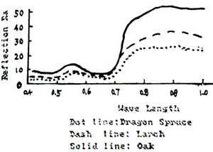
Figure 1

Figure 2
3. Successes in monitoring with Landsat
In 1969, Li Gusheng analyzed the disaster of needle-early-falling disease of larch in Shongshan forest farm (Jilin, China), defined the range and extent of the disaster.
Dai changda et al., in 1989, analyzed the Greeness change Index of the man-made larch forest in Gushan Forest Farm (Chuzhou, Anhui) by using NPVI (Normalized Perpendicular Vegetation Index) calculated from the reflection ratios in channel 3, 4 of Landsat TM. The pest-damaged area derived from this method differs from the pest-damaged area derived by the on-the-spot survey only in 1%.
It is testified by the works above that we can monitor forest pest-damage effectively by using TM data. But owing to the complex weather condition and long time interval between two orbits of landsat it is very difficult to get useful TM data. There were many severer pine caterpillar damages in the east part of Daxing' anling Area harmful for a real-time monitoring of pest damage.
4. Attemptment in monitoring with Meteorological Satellite
Both TIROS-N of NOAA and Fengyun-1 of our country equipped with AVHRR. Their main spectrum section for monitoring the vegetation is much similar with TM's.
| Spectrum Section | TM | FY-1 | NOAA AVHRR | |||
| Channel | Range | Channel | Range | Channel | Range | |
| Visible | 3 | 0.63-0.69 | 1 | 0.58-0.68 | 1 | 0.58-0.68 |
| Near IR | 4 | 0.76-0.90 | 2 | .725-1.10 | 2 | .725-1.10 |
| Fare IR | 7 | 10.4-12.5 | 5 | 10.5-12.5 | 4 | 10.3-11.3 |
Meteorological Satellite has an outstanding advantage of passing same area several times in a day. Therefore t has the much more opportunities to get good images without could. Its disadvantage is that its resolution at the nadir of satellite is only 1.1 km, its pixels are most mixed pixels. According to the concrete situation that there is only one type of tree-larch in Daxing' anling Area and the monitoring area is so vast, we have made a series monitoring since last year.
We can get two kind of informations from AVHRR output. One is false color images composed by channel 1, 2, 4 (for NOAA-10/11) or 1, 2, 5 (for FY-1). The other is the Distribution Map of VGI (Vegetation Greeness Index). In data processing, data observed in Channel 1 and 2 were turned reflection ratio after calibration, correction of zenith and distance between Earth and Sun. reflection ratio itself was made correction of atmospheric influence.
Owing to the reflection ratio in channel 1 and 2 has a good interrelatation with the cover degree and growth situation of green plant, VGI given by the linear composition of the reflection ratios in two channels will give out more information about the biomass and growth situation, and decrease the atmospheric influence in some extent.
Two kind of vegetation index, Normalized Difference Vegetation Index (NDVI) and Ratio Vegetation Index (RVI), were used in monitoring the Daxing' anling Area. In spring, When trees are not lush, we adopted NDVI.
| NDVI = | IR - R ---------- IR + R |
In summer, When trees are lush and rank, We adopted RVI
| RVI = | IR ---------- R |
In the formulae above, IR and R the reflection ratios in Channel 2 and 1 respectively.
Because the monitoring area is not so large, almost all data are obtained in the area near the nadir.
In the process of monitoring attemptment, we analyzed and compared the data from TM and AVHRR in same periods for 2 times, compared with the false color images composed with Channel 3, 4 and 5 of TM with ones from Channel 1, 2 and 4 of AVHRR, except for the difference of resolutions, the macroscopic distribution of color matched with each other, the areas with significant color changes are relatively consistent. Based on the principle of optics coding, we made a visual classification on TM Photostat interval of 0.01 degree of longitude or latitude. We made a correlation statistical analysis with the classification results and VGI data from AVHRR. The correlation coefficient is 0.91, significant level is 0.001.
In the course of practice, We made some geological calibrations on the schematic map printed on computer printers, with remarkable earth marks. Then we decided VGI criteria for different degree of pest damage based on the on-the-spot survey in the sample pest damage area. For a pixel at the nadir stands for the area of 1,100 mu, besides pest damage, a lot of factors such as cities, riverbeds, fired forest area, have also influence on the VGI. So we had to remove all influence of these factors.
As it is said above, the primeval forest in Daxin' anling Area has a feature of vast land, small population and poor traffic condition, the forestry unit could not give out an authoritative information about the pest damage situation made by ground investigation. So it is impossible to make an overall examination of remote sensing analysis of pest damage we offered. But this kind of work has been welcomed and highly evaluated by some forest conservation institutions. They consider that the schematic map of pest damage made by remote sensing is very similar with the results of on-the-spot survey and airplane investigation, and it has been put into wide use as a policy-making basis of comprehensive management of pest damage.
5. Conclusions and Prospects
- AVHRR of meteorological satellite could be used in an effective monitoring of large area forest pest damage. For it has an advantage of good temporal resolution, it could accumulate a series of data to make a dynamic monitoring of developing trends of pest damage. This could not be done by Landsat.
- Monitoring forest damage with meteorological satellite has many advantages such as real-time work, easy operation and low cost. It can provide valuable macroscopic developing situation for those areas where the comprehensive prevention and management is in urgent need.
- In spite of advantages above, meteorological satellite has a disadvantage of much lower resolution than Landsat. Therefore, when it is possible, we should better combine TM an AVHRR data into synthetic analysis by multi-level and multi-way remote sensing method. When a real-time macroscopic monitoring is being done, it should depend on AVHRR data mainly. On the other hand, when the precise location and amount of pest damage is to be determined, it should depend on TM data.
- For a better use of remote sensing information, ground work is also very important. In addition to intensifying on-the-spot survey combining with forest area exploration, application of GIS (Geographic Information System) and construction of data base is also indispensable. These should be taken into account when a common practice operation system for prevention and management of forest pest damage is to be constructed.
Mr. Liu Zhiming and Mr. Zhao Wenjing did much useful work in on-the-spot survey and analysis of data.
Bibliography
- Li Gusheng et al. , Correlation between Multi-spetrum Remote Sensing Information and Forest Pest Damage and Its Use, Preceedings of "Forest Pest Synthetic Management Seminar", Oct. 1989.
- Li Gusheng et al. , Application of Satellite Imagery in Forest Conservation, Information of Remote Sensing, Vol. 4, 1989.
- Dai Changda at al. , An Approach of Monitoring Pine Caterpillar Using TM Imagery, Proceedings of the 11 th ASIAN Conference of Remote Sensing, NOV. 4, 1990.
- Wang Yanyi et al. , Study on the Feasibility of macroscopic Monitoring the Crops Growth Situation in Jiangsu Province with AVHRR of NOAA, Research Papers on Environment Monitoring and Crop Yield Estimating, March 1991