| GISdevelopment.net ---> AARS ---> ACRS 1991 ---> Agriculture/Vegetation |
Landslide Hazard Remote
Sensing Information System
Wu Jingkun, Ruan Qiuqi,
Wang Aijun
Northern Jiaotong University Beijing, China
Northern Jiaotong University Beijing, China
Abstract
The Remote Sensing information system concerning landslide hazard consists of the landslide Remote Sensing image data base, the management system of data base and image processing system. The Baotian railway was selected as an experimental area. The system was set up on the microcomputer.
The experimental results show that landslide Hazard Remote Sensing Image information system (LHRSIS) is a strong means for the forecasting of geological hazard. It provides an important technological method for railway gress – roots unit.
Introduction
Landslide is a geological hazard which is often met in engineering construction of mountain areas. It can break the traffic, damage the mine, block up the river, lead to flood, bring the catastrophes to human life and production. Therefore, it has become an important research project to engineering geological experts.
The landslide hazard Remote Sensing information system (LHRSIS) consists of the landslide Remote Sensing image data base, the data base management system and image processing system. The Baotain railway is selected as an experiment area. The system is based on microcomputer.
The landslide Remote Sensing image data base includes the landslide Remote Sensing image from the aerophotograph first, interpretation map, landslide stereo image processed by microcomputer, image of dynamic development, important landslide distribution image around the railway line, concerned topography geological information data and Chinese characters explanations etc.
The data base management system is developed on the basis of Chinese dBase III system. The functions of this system have not only image register, inquiry, classify, copy and delect, but also have a large number of man-machine interactives which are the characteristics of this system.
The functions of image processing system are image input, display, storage and image processing. It has a image processing software package which consists of plentifull multi-purpose image processing programs. It is a tool of complex function and convenient implementation.
Experiment
I. The properties of the landslide hazard of Baotian railway
Baotian railway (Baoji – Tianshui) is 150 Km long. It leans on the north of Qinling mountain and gets near the south of Liupan mountain. It lies along Wei river. It keeps to the maintain and near the river, through the mountain and over the river, the topography and geological condition are very complex. From the view-point of the area geological structure, the railway goes through the structure zone of the Northern part of the Qinling mountain from east to west. The pressing effect is very strong. The fold axis line and main faults are distributed in direction from east to west. Wei river has been developed by Fenwei graben along east-west strike because this area has undergone complex structure motion many times since palaeoidic, magma actives frequently. The rock exposed show that granite and diorite are distributed widely in Yanshan and Hercynian period, except metamorphic rock system of per-cambrian and palaeozdic era, cretaceous system and a small amount of tertiary sedimentary rock. The Quaternary loess also exists. Due to the railwayline stretches along main fault of the Wei river basically, the rock is tattereder, under synthesize action of the atmosphere precipitation, underground water and inappropriate exactions, a large number of the landslides and collapse disaster have occurred. According to statistical information, there are more than twenty important land slides. There are four kinds of major land slides appeared along this railway line according to the matter composed. They are loess slide, accumulate-earthslide, fracturing – rock slide and rock slide. They will be introduced as following.
- Loess slide
The features of loess slide are : slide scales is large, development is rapid, deformation is sharp, destroy power is strong. For example, the Wolong temple slide. The major reason is that cutting slope border is too high over height and the action of the underground water.
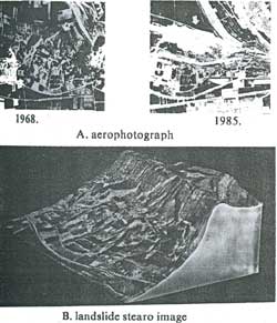
Fig. 1. Wolong temple landslide
The Wolong temple slide is located on the east of Wolong temple railway station about 2 km, on the slope of front fringe of four step terraces in the west of triangle zone where Wei-river and Qiangyang –river coverage. On August 18, 1955, after torrential rain, the earth massliding occurred, the railway was pulled out about 110m to southern, the houses and cave dwellings were damaged completely, endanger is serious. The slide about half circular on the plane, a step form on the section. It consists of three steps. The slide wall steep on the top and mild on the bottom, 30m high, in an arc form. The slide lake was formed under the wall. The landslide wall often collapsed and the slide lake has been filled by the collapsing loess in August 1958. The back fringe and two slides of the slide and boundaries of the old landslide, it is collapsing loess slide that the old slide revives. Now, the back fringe of the slide still has not been finalized. The shape features of the slide boundary, slide wall, slide step and slide hillock are very clear in the aero photograph. The slide wall presents light tone. It is discovered that the slide still develops toward back and east through comparing two different period aerophotographs. (See Fig. 1).
- Accumulation – earth slide
For example, three slides distributed in the east of Guchuan belongs to this kind of slides, it’s matter mainly consist of cliff deposit materials of the sand clay mixed up with broken stones. Because of artificial cutting slope in building road and movement of underground water, the stability of the earth mass is destroyed. So the slide, occurs. As shown in Fig. 2 The anti-sliding piles, changing of ditch and discharge water hole processing have been used in No. 2 slide, but due to steeper slope and effect of the broken zone fissures and pressure water, the side ditch of the road chasm still changed.
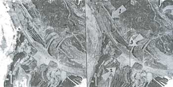
Fig. 2. Aeorophotograph of the accumulation earth slide
- Fracturing – rock slide
Like Putoyuan slide group, they are located in the west side of Putaoyuan railway station about 1 km. The land slide distributes along the Wei River fault zone. Slide mass consists of middle Devonian system (D2) fragmental chlorite – schist and gouge materials. The features are multi-times, mulit-pieces, multi-levels, multi-layers displacement, structure complex. Now it is still not stable.
- Rock slide
For example, the distributed slide in the west of Shishulin railway station belongs to this kind of slide.
Because of limitation of piece of paper, the example of the landslide scan not be intruduced one by one. They will be shown in the land slide hazards Remote Sensing information system.
The landslide hazard Remote Sensing image data base is multi environment essential factor data base on unified geography coordinate. The time sequence of the spatial information is formed through continual accumulation. Thereby the forecast and prediction of the natural environment active change are achieve. A strong tool is provided for railway safety management and construction, assuring security of the national properties and people’s life.
As known to all, the quantity of the Remote Sensing image data is very large. With the passage of time, the date accumulated increase rapidly. If there were no advanced equipment about data acquisition, input, storage, inquiry, processing etc. Therefore would be difficulty in setting up such environment system. Fortunately the microcomputer technique had been developed rapidly. The environment information system can be developed with lower cost. Now the microcomputer performance is more and more advanced. The processing speed is much higher. The storage ability is larger. Operation is very convenient. Therefore it is very easy to spreads and popularizes the system.
The landslide Remote Sensing image information system is the environmental information system based on pc/286 or pc/386. the hardware configuration is shown in fig. 3.
The host computer is pc/286 (or pc/386) with 2Mb memory, 20MHz clock frequency, color terminal having EGA or VGA adaptor, more than 80 Mb hard disk., 1.2 Mb and 360 Kb floppy disk.
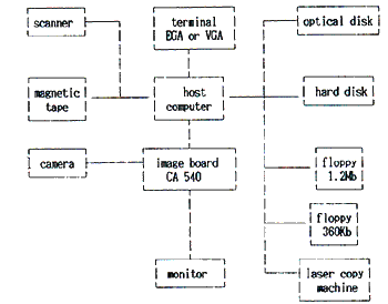
Fig. 3. The hardware configuration
The image processing subsystem is CA540 true color image board that includes the three A/D, D/A, three LUT and four 512 x 512 x 8 image buffers. The image input equipment is ccd camera. The output equipment is a high resolution color monitor which can display the color Remote Sensing synthetic image. The system can be expanded flexibility. For example, the input equipment can be high resolution color canner or tape machine. The output equipment can be laser hard copy machine etc. In a ward the minimum hardware configuration is the Kernal of the system and it can be expanded flexibility according to the requirement.
The software of the system includes tow parts : system software and application software. The operating system is Dos V3.3. The application software consists of the data base management software and the image processing software package. The UCDOS is used as the system software.
The dBase III is relationship type data base management system which is widely used. This kind of language provides a set of complete commands which are very convenient to users. There are one billion recorders in every data base. It allows access ten data bases at the same time. The pull-down menu is used in the management system for building a friendly user interface of the landslide Remote Sensing data base. At the same time the striking color and clear Chinese language prompt is designed.
1. As long as the user inputs simple command, the systems enters in the management system of the data base.
2. There are eight functions shown in the main menu. They are image input, image delete, image copy, image enquiry, image display, image processing, image type and system quit. When user selects a function by using “arrow” key on the key board the function menu can be shown as striking color. If return key is pressed the system entries second level submenu.
The image data can be stored by using camera or floppy. (If necessary, the tape or scanner can be used). At the same time, the image No., name, sort, scale, size, address of taking image and simple explanation are stored respectively. The multi-inquiry way is created. When the data base is used, the inquiry operation can be implemented according to any index. As long as inquiry procedure is implemented, the simple explanation will be shown in the terminal screen. In the meantime the image is displayed in the monitor. The image founded by user can be copied to risk or tape. This function can meet the need of the information exchange. If a hard copy is needed, you can use the image print function. The image processing software package provides a large number of image processing software. It is a processing tool of the complex function and convenient implementation.
3. Image processing function The landslide disaster Remote Sensing information system includes an image processing software package. There are abundant softwares in the image processing software packing. For example image mathematic operation (+, -, x, /), imager filtering, image edge enhancement, image transformation, image restoration etc. This software package can be used conveniently by interactive Chinese language prompts.
Conclusion
The landslide disaster Remote Sensing image data base is a smallsize multi-function relationship type data base management system based on dBase III.
The hardware of the system is the microcomputer which the cost performance is ratio superior. It has the advantages of complex function, low cost abundant software, high efficiency and practicality and easy manipulation. It provides important technological tool for railway grass – root unit. The results of the image processing are clear and accurate.
It is strong tool for geological hazards forecasting. The experiment results show that it is a practical and effective Remote Sensing information data base system.