| GISdevelopment.net ---> AARS ---> ACRS 1991 ---> Agriculture/Vegetation |
About the Distribution of
Shifting Cultivation in Northern Thailand Based on Landsat TM Data
Ken-inchi Shibata, Tetuji
Yamamoto
Kokusai Kogyo Co., Ltd.
3-6-1, Asahigaoka, Hino, Tokyo, Japan
Hiroshi Watanabe, Wataru Oohira
Japan Forest Technical Association (JAFTA)
7, 6 - Bancho, Chiyoda - ku, Tokyo, Japan
Kokusai Kogyo Co., Ltd.
3-6-1, Asahigaoka, Hino, Tokyo, Japan
Hiroshi Watanabe, Wataru Oohira
Japan Forest Technical Association (JAFTA)
7, 6 - Bancho, Chiyoda - ku, Tokyo, Japan
Introduction
Shifting cultivation is still performed dominantly in the mountain area of Thailand, and is pointed out as one of the major causes of forest destruction. Although the shifting cultivation is prohibited by Thai law, it is actively implemented in the deep mountain areas. The forest authority of Thailand has tried to identify the land of shifting cultivation by aerial photograph for the purpose of forest management. But the method of aerial photograph necessitates much time and cost to grasp the state of forest over the wide areas.
We have tried to identify the land of shifting cultivation at a part of Mae Hong Son Province of northern Thailand, and at the same time to grasp the characteristics of it. Using LANDSAT TM data. We will introduce the results of our study in the following.
We will be happy if our investigation method and its results will contribute in any way to the forest management in the future.
1. About the shifting cultivation in South East Asia
In general, the shifting cultivation in South East Asian countries is classified into three methods of long term fallow, short term fallow and extra long term fallow.
The long term fallow method has been traditionally implemented from the ancient time, whereby they lumber the forest, dry the field, burn the field at the end of dry season, and plant the rice and corn on the field thus cultivated. After repeating the harvest for 1-2 years, the land is left in fallow for 10 - 15 years. During this fallow period, the secondary forest will grow up. The same process is repeated by lumbering this secondary forest. In this case, the weeds are not abundant in the first year, so one or two times weeding is enough. But in the second year, the weeds increase to three time of the first year, and they move to anther place because it needs much labor to weed out the grasses. This is a method to take advantage of recovery of land power which take place during the fallow period.
The short term fallow method is employed by the inhabitants who have paddy field at the low land grow the land rice on the slopes of mountain near the village. This method is a repetition of process to grow plant in the first year, put the land in fallow for 5-6 years and then burn the land again. In this case, the full scaled secondary forests are not re-generated, and in many cases, the land is reduced to thick grove.
In case of extra long term fallow method, planting and harvesting are repeated continuously for several years, and when the land is fatigued, the village moves to another place giving up the current land. Therefore, the re-generation of forest is difficult at the abandoned land.
Today, large scaled field development (plundering slash and burn) is implemented under the extra long term fallow method by the low land residents, which is pointed out as the major cause of forest destruction.
The slash and burn which we have taken up as the theme of our study is the traditional extra long term fallow method, which is still now implemented at a part of northern Thailand.
2. Study area and LANDSAT data
The area we took up as the object of our study is located at the northeast of Mae Sariang in Mae Hons Son Province at the north of Thailand, where the Lua tribe is living dominantly.
The LANDSAT data we used is TM data which was observed n April 3, 1990. This is the season just after the field was burnt.
3. Investigation method and results
(1) Land cover classification
The land cover classification was conducted by making rough classification at first, then establishing training fields through the site investigation and again performing the classification by most proximity method. The main items of classification were forest, grassland, agricultural field by slash and burn, and paddy field, and the forest is further divided into evergreen forest, mixed deciduous forest and dry dipterocarp forest. The Image - 1 shows the false color image, and Image - 2 the classification image.
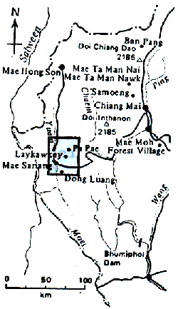
Image 1. False color image
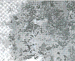
Image 1. Classification image
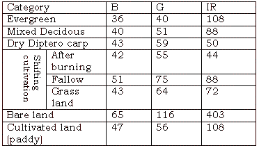
Also, Table 1 shows the spectrum characteristics of each classification item in CCT value.
(2) Extraction of shifting cultivation land
As for the land of shifting cultivation, the fields just after the burning and their peripheral burnt lands in fallow can be clearly identified on the false color image. It is assumed that grassland and secondary forest are developing at the peripheral areas.
(3) Grasping of characteristics of shifting cultivation land
We grasped the characteristics of the fields just after burning and their peripheral burnt fields in fallow which are clearly distinguished among the shifting cultivation land by overlapping the geographical information such as topography, vegetation and scale.
As a result, it has become clear that the shifting cultivation lands are distributed at south slope with comparatively gradual gradient of 10 - 200. Also, they are located at the altitude of 500 - 1000m, mainly among the evergreen forest and dry dipterocarp forest. The scale of shifting cultivation land is the rectangle of about 1.5 km (approx. 2 km2) on average.
(4) Land use on the peripheral areas
As the situation of land use at the peripheral areas, paddy fields are located mainly at the low land, and shifting cultivation lands are distributing at the slope land. Also, there are small sized villages such as Mae Sariang Village, but it is difficult to identify on the LANDSAT data. The shifting cultivation lands are spreading over the slope land, but there are not observed any large scaled landslide or conspicuous alluvial at riverbed.
4. Considerations
(1) About the classification of forest
We could classify the forests in the study area into 3 categories of evergreen forest, mixed decidous forest and dry dipterocarp forest in general. The evergreen forest distribute at the high land of altitude 1000m or more, the dry dipterocarp forest at the altitude of 1000m or lower, and the mixed decidous forest at the intermediate areas of the former two.
The observation data of LANDSAT TM was of early April which is the end of dry season. Since the decidous trees had already dropped their leaves in this season, it was easy to distinguish the evergreen forest and dry dipterocarp forest.
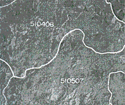
Figure 1 Location map of study area
(2) About the distribution of shifting cultivation land
The shifting cultivation is a method traditionally performed by a tribe called Lua, and as shown in Fig. 2, cultivation land is shifted at the cycle of 10 - 15 years. According to LANDSAT TM data, the area is classified into the field just after burning, the fallow land which is gradually changing to grassland and the land which has already changed to grassland. It is difficult to distinguish the land which changed to the secondary forest from the other forests especially the missed decidous forest. The data of plural seasons are indispensable to grasp the seasons are indispensable to grasp the whole of these shifting cultivation lands including all of these lands and areas.
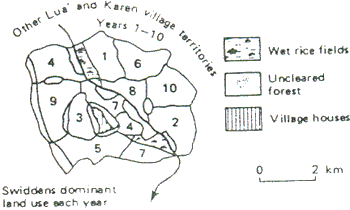
Figure 2 System of shifting cultivation
(3) About the characteristics of shifting cultivation land
Taking up the fields just after burning and the burnt lands which were clearly in fallow, we grasped the characteristics of shifting cultivation lands using the geographic information.
Although majority of the shifting cultivation lands are on the slopes facing with south, it cannot be said to be a conspicuous tendency because slash and burn fields are shifting every year as shown in Fig. 2.
The altitude is around 500 - 1000m, and species of trees are distributing among the evergreen trees and mixed decidous trees. As shown in Location Map of Fig. 3, there are past data that the shifting cultivation lands of Lua tribe were mostly located at the boarder line of evergreen forest and dry dipterocarp forest at around altitude 1000m.
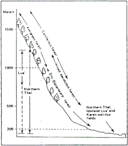
Figure 3 Location map of shifting cultivation
The shifting cultivation land is rectangle of 1.5 Km in scale, which is also coincides with the past investigation.
The gradient of slope of the shifting cultivation land is comparatively gradual at 10 - 200. This area is composed of the slope lands of gradual gradient, and most of the mountains are used as the shifting cultivation land up to their ridges. But where the mountains has acute slopes, only the area up to the breast is used as the cultivation land.
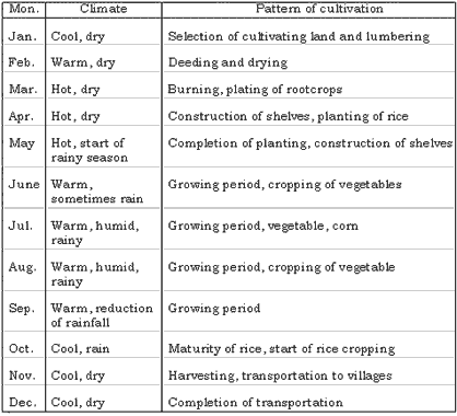
The yearly cycle of shifting cultivation is as shown in Table 2. Since the LANDSAT data we used this time were those obtained just after field burning, it was effective for identifying the fields after the burning. On the other hand, it was difficult to identify the secondary forest as the shifting cultivation land because it has the same spectra as the surrounding forests.
On the other hand, in order to investigate the influence of shifting cultivation, we observed the devastation of land basing on the situation of land use in surrounding areas.
As a land use in these areas, paddy fields are developing at the low land taking advantage of abundant water. Double cropping of rice or rice and other plant are carried out in some areas, and the land is used quite effectively. At the slope land in mountain area excluding the low land, the shifting cultivation in dominant as stated in the above, which is mostly concentrating at the breast of the slope lands. The are forests on the top and foot of acute slope. The evergreen forest distributes at the mountain top, and dry dipterocarp forest at the mountain foot. It is difficult to know the dynamic state whether the shifting cultivation land is expending from the LANDSAT data of only one season. The devastation of land at this point of time does not seem to be so conspicuous as there were observed no large scaled landslide or alluvial at the riverbed. However, there is no evidence that the extensive slash and burn agriculture does not lead to the devastation of land, and therefore, it is desirable to continue monitoring these areas constantly.
5. Summary
- In our present study, we grasped the situation of shifting cultivation at one point from a macro point of view using the LANDSAT TM data of one season.
- The study area was a part of northern Thailand where shifting cultivation has been traditionally carried out by Lua tribe. The forests in this area were roughly classified into three categories of evergreen forest, mixed decidous forest and dry dipterocarp forest, among which shifting cultivation lands were distributed.
- In this area, slash and burn is repeated at the cycle of 10 -15 years. The shifting cultivation lands which could be identified on the LANDSAT data were those used in recent years and it was difficult to identify the shifting land where the secondary forest has already grown.
- The shifting cultivation lands are located at the breast of slope at the altitude of 500 - 1000m where the slope is rather gradual at 10 -20o, and the rice and corn and grown at those fields. As a scale, the shifting cultivation land is a rectangle of 1.5 km in size.
- The surrounding areas of shifting cultivation land are mostly forest excepting the low lands which are used as paddy field. There are shifting cultivation lands in fallow amount these forest, and villages are scattering low land of mountain area.
- There was seen no conspicuous trend of devastation of land such as soil erosion from the data of this season. But since the extensive or plunderous slash and burn may lead to the destruction offorest and devastation of land in the future, it should be necessary to conduct adequate monitoring on this area.
We have grasped the distribution of shifting cultivation lands using LANDSAT TM data of one season. But in order to grasp the situation time-sequentially, it is desirable to grasp more detailed and dynamic state of these lands using the data of plural seasons.
Although we could not confirm the existence of plunderous slash and burn agriculture by our present study, it is desirable to monitor whether the shifting cultivation land is expanding or plunderous slash and burn is taking place using the data of plural seasons, basing on which restricting extensive use of land. It should also be necessary to make full use of these study results for the forest management which may lead to the effective use of lands.
Bibliography:
- Society of Academic Development of Japan: Plants and Agriculture/Forestry of South East Asia, Jan. 1990
- Kunstadter, Chapman, Sabhasri: Farmers in the Forest, Jan., 1970.