| GISdevelopment.net ---> AARS ---> ACRS 1991 ---> Agriculture/Vegetation |
Land capability mapping with
Landsat Data and GIS : A Methodological Study for Northeast Thailand
C. Mongkolsawat, P.
Thirangoon, S. Pongsai , A. Sowana
Khon Kaen University, Thailand
Khon Kaen University, Thailand
Abstract
This paper provides a set of technique in the use of Remote Sensing data in conjunction with GIS technology with the objective of defining the agricultural capability of various land units. Udon Thani province, Northeast Thailand, was selected as a test area. A set of themes required for this operation was examined and defined. These include slope (Gradient), elevation, land cover, terrain and soil type. A digital elevation model (DEM) which provides slope (gradient) and elevation data was generated form existing topographic maps. Terrain and land cover conditions were incorporated using two geocoded Landsat TM images. In addition, a soil map was transferred to the same geographic co-ordinates. The data input layers were organized thematically. The overlay operation is performed to identify areas where a set of specified conditions occurs together. The resultant map displays the land units according to their inherent characteristics and indicates the capabilities for various types of land utilization.
Introduction
Northeast Thailand is threatened by the rapid increase in the number and extent of development activities. These activities have resulted in the rapid depletion of natural resources. Over 50% of the forest reserves were encroached upon for agriculture between 1976 and 1989. The forest reserves covered an area of about 41,494 Km2 in 1976 and only 23,586 Km2 in 1989 (Royal forest Department 1989). The soils in the region are inherently low in fertility with sandy texture. Deforestation, in conjunction with coarse textured soil has led to severe erosion over an extensive area. This accounted for approximately 11,696,20,400 and 36,592 Km2 for severe, moderate and slight erosion respectively. (Lekakul, 1990)
In addition forest clearing has resulted in a marked increase in soil salinization (Thai-Australia Tungkula Ronghai Project 1983). An estimated 28,480 km2 of saline soil was reported by the Department of Land Development. The consequences have seriously decreased agricultural productivity and lead ultimately to local poverty.
Development activities should be planned so that the livelihood of the people and future generations is compromised. This can be achieved by ensuring that the sustainable development of natural resources is a major part of the future economic plans. Land capability mapping is the basis for sustainable development by ensuring correct landuse according to its capability for sustained economic production. In the past, land capability mapping for agriculture was carried out using traditional methods. There were no effective tools to help merge information from diverse sources and of different scales. GIS technology in combination with remotely sensed data offers the possibility of analyzing a number of different variables in order to obtain optimal landuses management.
This study provides a techniques in the use of Landsat TM data and GIS with the aim of identifying land units according to their capability for agriculture in the Northeast.
The study area
The study area lies between 17 00 N and 17 30 N latitude and 102 30 E - 103 00 E longitude corresponding to map sheet 5543 I - 5543 IV of the Thai Royal Survey Department. Geologically the area of Udon Thani Province is underlian by a thick sequence of Mesozoic rock of the Maha Sarakam, Khok Kraut, Phu Phan, Soa Khua and Phra Wihan formations. Quaternary deposits are sporadically distributed. The landforms of the area include the Phu Phan anticlinal / synclinal structures, a gently sloping piedmont and low relief area of terrace areas of terrace and river line lowland.
Mean annual rainfall is approximately 1300-1400 m.m. with 60% of the total during August to September. The area can be classified as Tropical Savanna (type Aw in the Koppen System).
Data sources and methodology
Details of land capability class were derived from the following sources :
- topographic maps of the Royal Thai Survey Department at a scale of 1:50,000.
- Landsat Thematic Mapper Imagery : two geocoded color composite images (bands 2, 3 and 4) acquire on December 1988 and August 1989 at a scale of 1:50,000.
- Detailed - reconnaissance soil maps of the Land Development Department at a scale of 1:100,000.
It should be noted that this study focuses on physical land classification. However socio-economic factors play and equally important role in the choice of land utilization type.
A combination of physical parameter required for the land classification was defined and identified. The classification concept is based on an integrated scheme with five GIS layers as described herebelow. It should be noted that this classification is not designed for recreation or wild life purposes and is not extended to show land capability of ornamental plants. The procedure consist of 1) organization of geographic input data 2) establishment of GIS data layers with survey for ground truth 3) overlay formations and analysis 4) map output.
Organization of geographic input data
The allocation of land into the capability classes is determined by integrating the class values of the parameters (attributes) for the study area. These include elevation, slope gradient terrain, soil type and current land cover. Each parameter is a thematic input layer for GIS operation.
Establishment of GIs data layers and ground truth survey
A GIS data layer consists of a set of logically related land components are described above and their attributes. The layers were derived from many information sources ; topographic maps, Landsat TM imagery and soil maps.
- Elevation and slope (gradient) maps were prepared from digital elevation models (DEM) which were generated using topographic maps. The DEM was carried out by rasterization of digitized contour lines. The finite difference method was applied for interpolating elevation values. Elevation and slope unit were then identified according to preassigned class values.
- A terrain map was produced using Landsat TM imagery at 1:50,000 scale. The mapping procedure included several steps of imagery interpretation and ground truth survey. In the study area, soil moisture condition and vegetation cover provide clues in terrain differentiation (Mongkolsawat, 1988).
- A land cover map was extracted from the same Landsat imagery
- A soil map produced by a land development department (1972) at a scale of 1:100,000
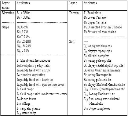
The rasterized layers included elevation, slope (Gradient), terrain, landover and soil all of which are used in the overlay formation and analysis.
Overlay formation and analysis
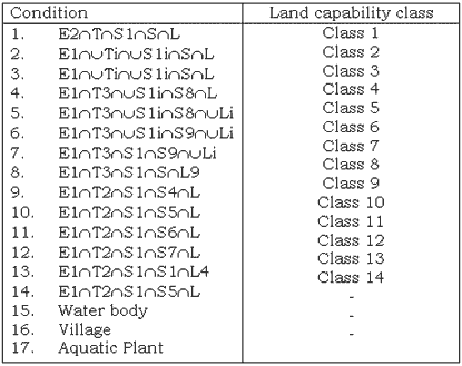
This involves identifying the area where a specified combination of conditions occurs together. The rasterized layers as defined were represented as separate layers in the PAMAP GIS. The overlay operation model of the GIS was then applied to the five rasterized layers which yielded a land capability layer on map form. This output is based on the specified combination of conditions occurring on each area. The combination of condition for land capability classes is shown in Table 2.
Map Output
The output product results from integration of the overlay information on the form of a rasterized polygonal display which carries information on the conditions within each polygon. These polygons were then cross hatched (vectorized) to produce a low-cost paper map.
Results and Discussion
The results of the study are presented in the form of map with a descriptive legend. The map has 14 classes of land capability as shown in Table 3. The area occupied by each class also shown in table 3. A section of the map area is illustrated in figure 1.
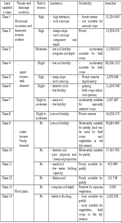
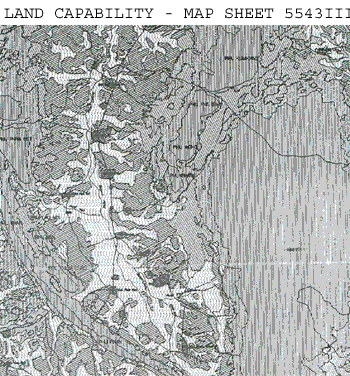
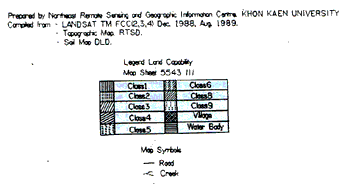
Figure 1 A section of the map area
As shown in Table 4, land capability class 4 is the most widely distributed of the upland land types (85, 487 ha). Land capability class 9 is the most widespread of the lowland land types (95,684 ha). Thus, low fertility, loamy soils (types S4 and S8) are the most significant in the study area and clearly have a limiting effect on the agricultural development.
Note

The effectiveness of land capability classification as a tool for achieving sustainable development is readily demonstrable when one considers the case with which it is possible to identify the agricultural limitation of the various land capability classes (table 3). The methodology adopted can be easily applied to other areas of similar geologic and pedologic conditions. It should be noted that the classification does not include all of the possible land variations in Northeast Thailand. More classes will need to be added, for a complete regional system.
References
- Department of Land development, 1972 detailed. Reconnaissance soil map, Udon Thani province. 1:100,000 scale, soil survey division, Bangkok.
- Lekakul, 1990. soil and water conservation in the Northeast. ADRC Seminar 14-16 Nov. 1990. Khon Kaen
- Mongkolsawat, C. 1988 An evaluation of Thematic Mapper Data for land Resource survey in northeast Thailand Proceedings of the Ninth Asian Conference on Remote Sensing Nov. 23-29 1988, Bangkok.
- Royal Forest Department, 1989 Forestry statistic of Thailand, Planning Division, Bangkok.
- Thai - Australia Tung Kula Ronghai Project, 1983, Tung Kula Rongai Salinity Study. McGowan International PTY LTD.