| GISdevelopment.net ---> AARS ---> ACRS 1990 ---> Agriculture and soil |
The method and practice of
macro Remote Sensing Monitoring of winter wheat
Xu Xiru, Zhu
Xiaohong
(The Institute of remote Sensing Technology and Applications of Peking University)
Zhang Xuding
The Department of Mathematics of peking university
Beijing, 100871, China
(The Institute of remote Sensing Technology and Applications of Peking University)
Zhang Xuding
The Department of Mathematics of peking university
Beijing, 100871, China
Summary
China is developing country with large population and less arable land. It is strategically important to have a bumper ha vest for Chinese economic development. It is necessary step for scientific and democratic administrative management to apply remote sensing technique for realizing timely monitoring of crop yield. The most models were directly established between spectral parameters and yield of winter wheat by statistical method. (1) (2) (3) in fact, the yield of winter whet id determined by three factors (ear number (S), grain number (L) and grain weight (Z), they are formed in different stage and are controlled by different, main factors, so the method of estimation of winter wheat yield should be based on the relationship between spectral parameters and the three basic factors which form the winter wheat yield. Authors had utilized the synchronized spectral parameters and necessary agronomic data gained form controllable sample fields to analyze the relationship between three basic factors and remote sensing data adding non-remote sensing parameters.
The forming of yield depends on slow accumulation of photosynthetic products, but any kind remote sensing images only offer an instant information of spatial distribution of spectral reflectance. The contradiction between spatial and temporal continuity is always the core of problem, for this reason non-remote sensing data and GIS are necessary for yield estimation of winter wheat. The theory of decomposition of mixed pixel had made it possible to realize macro monitoring of winter wheat using low resolution AVHHR data.
Model of estimation Of winter wheat
It is well known photosynthesis is the basic course for vegetative growing :
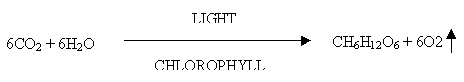
The chloroplasts catch photos to offer necessary energy for dark reaction of photosynthesis, so the amount of chloroplasts are directly related to the most possible biomass. K.P. Gallo and C.J. Tucker (4) (5) had proven the close relationship between spectral parameters and effective photosynthetic energy of crop from experiments and theory respectively. So, people can get correct information of spatial distribution of chlorophyll density from remote sensing data. If we measured the spectral parameters for whole life to winter wheat, then the total biomass, the ratio between them have been called economic coefficient. Many models treated it as constant. As a matter of fact we can easily find many samples, their total biomass are similar but their yield are quite different. The key problem is that the three basic factors are formed in different stage and their decisive factors are not the same. At one side they are related to each other, on the other side they are distinguished from each other. Therefore the correct method of yield estimation by remote sensing technology hast o explain the relationship between spectral parameters and three basic factors.
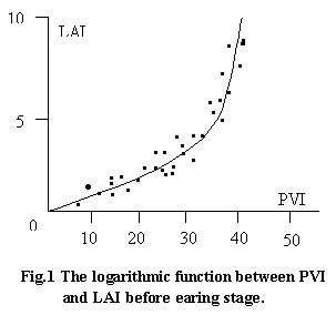
We intent to find out the relationship between them through control able sample fields. We planted winter wheat into a cement pool with bottom sealed. The irrigation water and fertilizer are controlled in order to enlarge the span of yield among different sample fields. We measured spectral reflectance of winter wheat, leaves area (LAI) for whole life, the amount of irrigation water were recorded. After harvest we measured ear number(s), grain number (L) and grain weight (Z) for every sample field. Because spectral reflectance of soil background with different irrigation water is different, so we adopted PVI as a basic spectral parameter in order to filter the influence of soil background better.
The experimental results show that logarithmic function is fit for PVI an LAI before earing stage. Please see the Fig.1 the value of LAI will reach its climax at earing stage (LAImax). If we call LAI/LAImax standard leaves area index (LAIn), the a universal law of LAIn (t) does exist which is mainly controlled by day temperature accumulation. One stem has one ear, so LAImax keeps linear function with ear number. Therefore the ear number can be judged by measurement of PVI corresponding day _ temperature accumulation. One stem has one ear, so LAImax keeps linear function with ear number. Therefore the ear number can be judged by measurement of PVI and corresponding day temperature accumulation data. The logical relation can be expressed by

because of the emphasis of biomass increasing to be put on leaf's growing, so the effect of different environmental factors or different agronomic measures are totally reflected by value of LAI. Therefore it is necessary to consider to other factors when we juged S by PVI, sometimes it is practical to form an empirical formular such as
S= Aeb PVI dt
experimental
results show the weight of stem per unit length is closely related with
grain number and grain weight, it is obvious that ear number is determined
by colony, but the grain number and grain weight are decided by robustness
of individual. If PVI describs the effective photosynthetic intensity of
individual. The organ of grain was built from jointing stage to flowering
stage to be fixed at this time. The grain weight will be determined by
strength of milking and its duration. It begins at flowering stage lasting
to ripe stage.Winter wheat absorbs water from its root system, 99% water absorbed to be evaporated into atmosphere through leaves. The function of water keeps smooth transportation of material inside the body and makes cavities on the leaves open properly and let enough amount of CO2 coming, so soil moisture (Vw) becomes one of the factors to form grain number and grain weight.
Since the main stem to grow up early, it has enough time and nutrition to form big ear. The later the tillering happen, the higher location the tillering stems grew up, the lower possibility the big ear have. So the effective tillering number (T) is also one of the factors to form grain number (L).
For every sample field a linear equation may be constructed by grain number (L), PVI/S, Vw and T. For many sample fields a group of this kind linear equation can be formed. The pseudoinvers method was employed to calculate weight coefficient (a1, a2, a3).
L = a1 ( ò2 PVI.dt / s) + a2Vw
+ a3T --------------------(1)
The same way can be
used for grain weight Z = b1 ( ò3 PVT.dt/S) + b2Vw
---------------------------(2)
In our experiments every sample field is under the same temperature and insolation. If we use <1> and <2> tio practical situation, the first term PVI dt/S must be multiplied by mending factor of insolation hours.
It is a premise for correct estimation of yield to gain remote sensing data of whole life of winter wheat. At present only AVHRR data can relatively satisfy this premise condition. The low resolution of AVHRR has ever been considered a main obstacle for many applications. Certainly mixed pixels contaminates the spectral characteristics of winter wheat, at the same time the area sown with winter wheat will not be correctly calculated, but we can't say the mixed pixel problem may not be overcome. Suppose we have M pixels. N times AVHHR data have been gained. We calculated (PVI)i,j for every pixel. Where, i represents location of pixel and j means time. So a data matrix |D| can be formed :
n kind independent elements are within mixed pixel, then:
Where |A|i,k means the area ratio of Kth element in ith pixel, (PVI)kj
describe the PVI value of K th element at the time og j.
We call |A| the area distribution matrix. We call |PVI| the spectral parameters matrix, which can be known by field measurements.
|D| = |A| |PVI|
we have known |D| already generally speaking, |PVI| and |D| neither a square matrix nor a valued used to satisfy the "full rank" condition, so we cannot use |PVI|-1 to multiply both sides of (3) to know |A|. We perform principal analysis to |D|:
|D| = |R| |C|
Where |C| is the eigenvector matrix, so |C|-1 = |C|T
|D| = |R| |T|-1 |T| |C|
let |PVI| = |T| |C|
then |T| = |PVI| |C|T
so
|A| = |R| |C|-1
In HENAN province before earing stage only rape seed coexists with winter wheat. After earing stage many kind of green vegetation appear. Changes PVI value of different targets are shown in Fig. 2
The results shows before earing stage dfferetn target have different PVI(t) law, so we can calculate area ratio of winter wheat by pixel using AVHRR data before earing stage.
To realize macro monitoring of winter wheat for whole Henna Province under the support of IPS and GIS
Since yield estimation of winter wheat needs some necessary non remote sensing data, for example insolation hours, soil moisture, amount of seeds sown in the fields, we face three kind data for, rates image data, polygon data and attribute data GIS is the ideal tool to handle these data together. We had established a GIS on the micro-computer base.
The hardware system includes:
Host machine: AST-386C/3320 internal storage capacity is 3 MB, hard disk is 320 MB
The minor: SONY/PVM 1371QM, 512 x 512 x 8. with image data collector CA-C540
Tape driver: ABCUS-F-8806-U, red/write density is 1600 BPI, speed is 25/100 IPS
The digitizer: DT 8042
The plotter: AMETEK/DMP-60
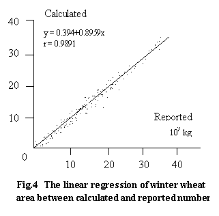
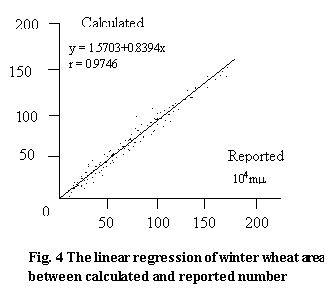
The software system consists of many modules. Tree configurations were employed to connect different modules. Good interface had been established to call each other through main module. It has basic image processing functions. Four data formats are adopted. The transform had been realized between raster data and vector for mate. We have basic manipulation, such as window, enlargement rotation, roam, four fundamental and logical operations of arithmetic etc. We realized the estimation of yield and area sown with winter wheat for whole Henan province from 1986 to 1989. Fig 2 and Fig 4 as an example show the relationship between the number calculated by us and reported by local authority.
Reference
- IDOs S.B. et al. Remote Sensing of Environment, 9 (1980), 87
- Tucker, C.J. et al Photogrammetric Engineering and Remote Sensing,
46 (1980), 657
- Idso, S.B. et al Remote Sensing of Environment, 7 (1987) 273
- Gallo, K.P. et al Remote sensing of environment, 17 (1985) 221
- Tucker, C.j et al International Journal of Remote Sensing, 7 (1986),
1395
- Tia, G.L. et al Remote Sensing of Environment China, 4 (1989), 73
- Xing, Y.Q. et al Remote sensing of Environment China, 3 (1988), 308
- Patel, N.K. et al, International Journal of Remote Sensing 6(1985),
657
- XU, X.R. et al Chinese Science Bulletin, 35 (1990), 317
- Xu, X.R. et. al, Asian Geographer, (1987), 109.