| GISdevelopment.net ---> AARS ---> ACRS 1989 ---> Education and Training |
Some results of using
Photographic Processing Facilities and Techniques for Landuses study in
Vietnam
Pham Trung Luong
Division for Application of Remote Sensing,
Center of Geography and Natural Resources of NCSR of Vietnam
Pham Trung Luong
Division for Application of Remote Sensing,
Center of Geography and Natural Resources of NCSR of Vietnam
Introduction
Landuse is most dynamic phenomina according of human and natural activities. That is why the investigation and study of land use pattern and detection it’s change need not only for scientific purpose, also very important for economic planning and for environment. The Remote Sensing data was being used in Vietnam for land use study from 1980 and since that time we have obtained some perspective results, which permits us to overcome the limitations of traditional method.
In order to improve interpretation quality of Remote Sensing photo/imageries, we must study and use some photographic facilities and technique.
These will be discussed in this paper with the results of using photographic facilities and techniques with different kind of Remote Sensing photo / imageries for Land use study in Vietnam.
The Main Results
The choice of information combination
Due to dencity of natural objects on photo / imageries ahs correlation with brightness coefficient.
(D – Co)/C
R = 10 /1/
Where : R = brightness coefficient
D : Density
Co, c : Contract for concrete photo / image
So we can choose channels or combination of channels which have information of interested objects through contracts brightness coefficient.
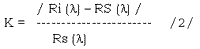
Where : Ri (l) : brightness coefficient of interested objects
Rs (l): brightness coefficient of surrounding objects
Data of brightness coefficient of main natural objects of Vietnam we can have from / 3/
This techniques had tested for multispectral photo MKF-6 to establish land use map of Tea Farm Minh Rong at scale 1/10,000 /4/
In this case, based data on maximum contract brightness coefficients in 6 channels. /1/
K1 = 480nm K3 = 6600nm K5 = 720nm
K2 = 540nm K4 = 660nm k6 = 840 nm
Maximum Contrast Brightness – Coefficients of Main Natural Objects of Tea Farm in Channels of Multispectral Photo MKF-6.
Table 1
| Tea (Health) | Tea (Diseased) | Dry Rice | Water Rice | Grass | Evergreen forest | Bare soil (with grass) | Roads | Water | |
| Tea (Health) | 0(All 6ch) | 0.50(ch 4) | 0.71(ch. 4) | -0.54(ch 6) | 0.53(ch. 3) | -0.31(ch.3) | 1.43(ch.4) | 1.28(ch. 4) | -0.95(ch 6) |
| Tea (Diseased) | -0.31(ch 4) | 0(All 6 ch) | 0.43(ch 2) | -0.46(ch 4) | 0.29(ch 2) | -0.47(ch 2) | 0.64(ch 3) | 0.93(ch 2) | 0.94(ch 6) |
| Dry Rice | -0.40(ch 3) | -0.33(ch 2) | 0(All 6 Ch) | -0.50(ch. 2,3) | -0.23(ch 5) | -0.58(ch. 3) | 0.55(ch. 4) | 0.45(ch.4) | -0.95(ch 6) |
| Water Rice | 1.17(ch 6) | 0.91(ch 4) | 1.00(ch 2,3) | 0(All 6 ch) | 1.10(ch.6) | 1.00(ch. 6) | 2.09(ch. 4) | 1.91(ch. 4) | -0.90(ch 6) |
| Grass | -0.35(ch 3) | -0.37(ch 3) | 0.29(ch 5) | -0.52(ch 6) | 0 (all ch 6) | -0.54(ch 3) | 0.79(ch 4) | 0.68(ch 4) | -0.95(ch 6) |
| Evergreen forest | 0.44(ch 3) | 0.90(ch 3) | 1.40(ch 3) | -0.50(ch 6) | 1.20(ch 3) | 0(all 6 ch) | 1.61(ch 4) | 1.80(ch 3) | -0.95(ch 8) |
| Bare soil (with grass) | -0.58(ch 3) | -0.42(ch 3) | -0.35(ch 4) | -0.68(ch 4) | -0.44(ch 4) | -0.68(ch 4) | 0(all 6 ch) | -0.25(ch 6) | -0.94(ch 6) |
| Roads | 0.74(ch. 6) | -0.48(ch2) | -0.31(ch 4) | -0.68(ch 4) | -0.67(ch 4) | -0.44(ch 4) | -0.68(ch 4) | O (all 6 ch) | 0.92 (ch 6) |
| Water | 20.70(ch 6) | 46.50(ch 6) | 17.50(ch 6) | 9.00(ch 6) | 20.00(ch 6) | 19.00(cg 6) | 16.00(ch 6) | 11.50 (ch 6) | O ( 6 ch) |
(table 1), we have chose 3 channels from 6, they are K3, K4 and K6.
The other channels are unuseful, specially channel K5. Application of this technique is reduction processing time and labours for interpretation with requiring accuracy and information.
This technique is good for using large scale remote sensing photo/imageries.
Color composition
Color composition of Landsat MSS imageries
This techniques carried out on additive color viewer (model Ac-90BB) for land use Mappimg. The color composition of MSS image in bands 4,5 and 7 for different geographic areas (palteu, coastal zone……….) have various colors. (Table 2)
Color Composition of MSS Imagery
Table 2
| LANDUSE OBJECTS | : | Color Composition
| ||||||||||||||
| : | Plateau
|
: | Coastal Zone
| |||||||||||||
| : | Color code
|
: | Colour | : | Color code
|
: | Colour | |||||||||
| : | band 4 | : | band 5 | : | band7 | : | : | band 4 | : | band 5 | : | band 7 | : | |||
|
| ||||||||||||||||
| AGRICULTURAL LAND | : | : | : | : | : | : | : | : | ||||||||
| Water rice | : | G | : | B | : | R | : | Dark Green | : | R | : | B | : | G | : | Bright Pink |
| Dry rice | : | G | : | B | : | R | : | Orange | : | - | : | - | : | - | : | - |
| Upland crops | : | G | : | B | : | R | : | Pink | : | G | : | B | : | R | : | bright Pink |
| Many year trees | : | : | : | : | : | : | : | : | ||||||||
| Commercial | : | G | : | B | : | R | : | Red | : | G | : | B | : | R | : | Dark red |
| Orchard | : | G | : | B | : | R | : | Dark red | : | R | : | B | : | G | : | Red to dark red |
| Tea plantation | : | G | : | B | : | R | : | Yellow | : | : | : | : | ||||
| FORESTRY LAND | : | : | : | : | : | : | : | : | ||||||||
| Evergreen forest | : | G | : | B | : | R | : | Dark red | : | G | : | B | : | R | : | Dark red |
| Pine forest | : | G | : | B | : | R | : | Dark yellow | : | - | : | - | : | - | : | - |
| Mangrove | : | - | : | - | : | - | : | - | : | G(R) | : | B(G) | : | R(B) | : | Red to dark red |
| Vegetation on | : | G | : | - | : | - | : | - | : | B | : | G | : | G | : | Pink to violet |
| sulfate soil | : | : | : | : | : | : | : | : | ||||||||
| forest | : | G | : | B | : | R | : | - | : | - | : | - | : | - | : | - |
| SETTLEMENT | : | : | : | : | : | : | : | : | ||||||||
| Urban (cities, towns) | : | G | : | B | : | R | : | Yellow | : | G | : | B | : | R | : | Red |
| Village | : | G | : | B | : | R | : | Red | : | - | : | - | : | - | : | Dark red |
| FOR SPECIAL USE | : | : | : | : | : | : | : | : | ||||||||
| for salt production | : | - | : | - | : | - | : | - | : | G | : | B | : | R | : | Bluish |
| Area for nurse of sea product | : | - | : | - | : | - | : | - | : | R | : | B | : | G | : | Darkish |
| OTHERS | ||||||||||||||||
| soil with grass and scrubs | : | G | : | B | : | R | : | Pink | : | G | : | B | : | R | : | Bright Pink |
| : | G | : | B | : | R | : | Dark pink | : | R | : | B | : | G | : | Dark pink | |
| : | : | : | : | : | : | : | : | |||||||||
|
| ||||||||||||||||
Color composition of SPOT imageries
In the programme of subject “Analysis of RS data assessment of natural conditions and natural resources and their dynamic on some coastal zones for inventory economic development and for environment which was been signed by RRSP (ESCAP) and centre of geography and natural resources f national centre for scientific research of Vietnam, in the first time the color composition of SPOT image has studied and applied in Vietnam. The techniques is also carried out on Additive color viewer AC-90B for land use in vegetation and study for coastal area of Mekong Rever’s plain.
Due to SPOT image has height resolution, so it’s different color composition in bands 1, 2 and 3 will allow more details classification of landuse units, specially of fields for salt production and urban (cities, towns) which are very difficult to classify by color compositions of MSS imageries (fig 1 and 2)
| Colour composition of MSS image for urban | Colour composition of SPOT image for urban |
| Fig
.1 | |
| Field for salt production on colour composition of SPOT image | Field for salt production on colour composition of MSS image |
| Fig .2 | |
Application of this techniques improves interpretation quality for Land use mapping.
Conclusions
Although using photographic processing facilities and techniques for land use study in Vietnam has begin recently, but it gives us some prospective results, reduces processing time and labours.
Some land use units like fields for salt production, urban and more detail classification of orchards and forest etc. can be defined by using technique of color composition with height resolution remote sensing imageries.
References
- Gonin G. B. “Space Image”. Publish house “Nhedra”. M 1980.
- Vinogradov B. V. “ Remote sensing methods for study natural resources” Publish houses” Nauca” M. 1979.
- Pham Trung Luong, Trinh Dinh cuong, Tran Main natural objects in Vietnam”. National Commission for Space Research VN, 1985.
- Pham Trung Luong, VO Duo Tuyen, Nguyen Ba Nhuan, Troung Thi Hoa Binh, Tran Minh Y. “ Ability of application of Remote sensing techniques for compiling land use map on the large scale in Vietnam,”. Scientific information, NCSR of Vietnam, 1, 1986.