| GISdevelopment.net ---> AARS ---> ACRS 1980 ---> Technical Session |
Discussion on the application
of Satellite Multispectral Scanner Digital Data to Mapping and Monitoring
Rice Production.
Keith R.
McCloy
South Australian Institute of Technology
South Australian Institute of Technology
Introduction
Rice is the staple grain food of East-Asia. Strong import demand for rice, and limited export supplies, have pushed the price the rice much higher than those for other grain crops . the instability of market is accentuated by significant annual variations in export supply by some of the exporting countries. The majority of countries of East Asia are rice importers so that variations in the price of rice, and the quantity that they will need to purchase, are important budgetry considerations for these countries (FAO Rice Report 1971/75). Therefore most governments of East Asia could use timely, reliable estimates of home production of rice in economic management.
Estimating yield from rice crops is made particularly difficult due to both thee cropping practices in Asia, and the varieties of rice that are available. The majority of the rice harvested in Malaysia is done so from small family plots, and similar conditions exist throughout most of East Asia. It is difficult for government agencies to keep current records of paddies that are farmed in this way. Also, different varieties of rice yield either one or two crops per year, significantly affecting the yield from the same area. Added to these difficulties, rice is subject to infestation by aquatic and semi-aquatic weeds, as well as being attacked by pests and plant diseases.
Mapping is defined as determining the spatial extent, to include both location and area, of rice paddy fields being used to grow rice. Monitoring is determination of the status or condition of the crop at stages throughout the growth cycle so as to derive estimates of yield from the individual paddy fields, which can then be aggregated over larger administrative regions. Mapping and monitoring are attempting to extract distinctly different sorts of information from the imagery. It can be expected that approaches considered suitable for one may not be suitable for the other. The problem is compounded by the complexity of the rural environment in East Asia where the paddy fields which are often small, fit into a patchwork of fields separated by bunds and roads, accommodation areas, grazing paddocks and stands of trees or bamboo. It is therefore assumed in this paper that any program established to map and monitor rice production will operate throughout the year utilizing satellite data that has rountinely been rectified t a map grid and whose response values have been corrected for sun elevation and atmospheric effects. Only in this way can imagery at different dates be reliably compared, although clearly the level of reliability is dependent upon the accuracy of the geometric rectification and the radiometric corrections that have been applied.
This paper primarily considers the suitability of the LANDSAT Multispectral Scanner data for this task. On current NASA predictions, Thematic Mapper data will be available from 1982, so the technical suitability of Thematic Mapper data has also been consider.
Technical Basic for Monitoring Rice Crop Condition
From the work of Kauth and Thomas (1976) and of McCloy (1979), the author has proposed a canopy reflectance mode (McCloy (1980) that is based on the premies:
- The reflectance properties of a canopy are dominated by the
proportions, and the reflectance properties, of the more populous
physical classes in the canopy.
Consider the response for a pixel that sense a surface area consisting of proportions of two primary classes. If the premise is correct then the response is dependent on the mix of those classes, and the mixed pixel algorithm (Horwitz el al , 1971) can be applied to show that the pixel response will be on a directed line joining the response vectors for the two primary classes (Diagram 1). Position on this line is dependant upon the mixture proportions. Second and lower order physical classes will affect response, but by a small amount relative to the length of the directed line . shifts in response due to these lower order physical classes will either be along the line and/or away form the line. The first will be interpreted as changes in the proportions of the primary classes, and the second considered to be either noise, or potential information. Pixels that are mixtures of three primary physical classes would have response values located within a planner triangle, in the four dimensional response domain. Thickness of this triangle provides some indication of the effects of second or lower order physical classes on response.
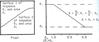
DIARAM 1
The advantage of the model is that it can be quantified, and is therefore amenable to digital image processing to yield estimates of physical conditions in the pixel using the pixel response data.
Quantification can be achieved using either the mixed pixel algorithm (Horwitx et al, (1971)) or the vector classifier (McCloy (1977a)). If the covariance arrays associated with each primary class are significantly different then the mixed pixel algorithm will yield the more accurate results, but if the distributions of the classes are similar then the vector classifier will be more economical.
Application in Monitoring Rice Crop Condition
In this discussion response will be related to the MSS Band 5-Band 7-Band response domain because there is generally least correlation between bands. It would, however, be normal practice to use all four MSS bands in the digital analysis.
A rice crop starts, prior to planting as a flooded, ploughed paddy field containing either turbid or shallow water, and with a nursery of densely packed seedlings in the near vicinity. The response for turbid water, similar to that which would be contained in a paddy, is shown in Diagram 2 as region TW. As the level of turbidity increases, so the response increases in both bands, moving from T towards W. This characteristic response has been observed for a series of turbid lakes in the South East Region of South Australia (See Diagram 3), and the same phenomenon has been reported in the literature by other workers. The length and orientation of the semi-major axis will change with variations in the spectral reflectance characteristics of the suspended material. If the paddy field contains clear water, then the response will be slightly different to that from turbid water.
As the crop grows the leaves created a shadow component. The pixel response is therefore affected by the background response from the turbid water, the vegetation and the shadow. The response during the growing season moves from its origin at the response for turbid water, for example at A in Diagram 2, towards the response for a dense canopy of green vegetation with a water background shown as R in the Diagram. If there was no shadow then the response would travel along the line A-R as the crops grow. The existence of shadow will mean that the response will follow a curved path and will lie in a plane triangle the vertices of which are the response for shadow, green rice and turbid paddy field.
The region of vegetation, V, would be the response for the green rice crop without any response effects due to water. However, of infrared energy. It is likely that there will be some radiation in the infrared penetrating through the canopy, so that the response from the full green rice crop is unlikely to reach V but instead reach a point in the vicinity of R. AS the crop ripens, and the paddy field dries out, the response will move towards the region of Yellowstuff, Y, which it would have reached prior to harvest.
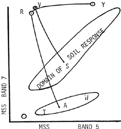
DIAGRAM 2
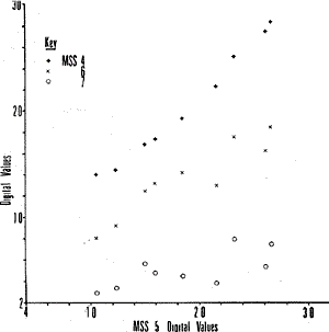
DIAGRAM 3: Mean response values for Nine lakes in western Victoria from LANDSAT frame 1129-23494 of November 1972.
If the paddy field was dry throughout the growing season, then the response would move along a curved line from the response from soil, S, to V. Therefore if the field dries out prematurely during the growing phase of the crop then the response will leave the curved line A-R and move towards this curved line S-V. The distance from the line A-R will be a measure of the amount of soil reflectance that is contributing to the pixel response.
For wheat monocultures the response during the growing season has been shown to be highly correlated with plant height, (Wiegand et al, (1978)) It can be fairly assumed that the same will apply to a rice crop of average planting density. Because plant height will be highly correlated with crop age, it should be possible to construct an age-response curve for rice as has been done for wheat (Badhwar 1980). If the crop differs significantly from this curve then some other factor is at work. Should the crop be exhibiting more green development than the age-response curve model would suggest, then that is likely to be due either to a denser planting of rice, or infestation by weeds. If the response is behind predictions on green development then the crop is likely to have been planted less densely than average or suffering due to deficiency or disease.
Analysis of changes in paddy field response throughout the growing season will provide information on crop condition. Utilizing the hypothesised response model, and the vector classifier, will yield estimates of the proportions of response due to paddy field, green crop and shadow from the response data. These proportions can be compared to the average proportions at the crops age to indicate the status of the crop relative to the norm. The advantages of this approach are that all of the processing can be done by computer and that the proportions of paddy field, green crop and shadow should be constant for a particular age and not affected by variations in bare paddy field response as the crop response will be. Computerisation of the procedure is important not only because of the number of calculations but because of the repetitive nature of the programme.
Consideration of other Surface Types during Monitoring
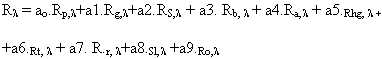
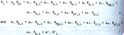
The discussion above has only related changes in response to change in condition within a paddy field. In practice the response for a pixel is an integration of the response due to all surface types within the pixel area, and these different surface type include bare flooded paddy field, p, green rice crop, g, shadow, s, bunds, b, accommodation, a, herbage, hg, tree and bamboo, t, roads, r, soil, sl, and other, o. The response for a pixel in wavelength l is therefore:
Now if imagery is acquired during the growing season then the proportions a 3 to a9 will not change from one date to the next. If it is also assumed that the response for these surface types do not change during the growing season then;
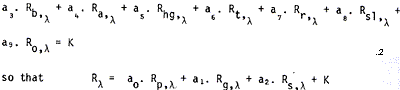
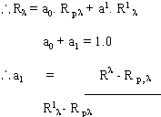
where the proportion of the pixel that is covered by paddy field is constant and known to be (1-a1). That is :

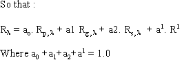
In equation 3, Rg, l and Rs, l are independent of location and can be determined from spectrophotometer data. R. p, l is dependant upon soil reflectance and hence will change with time in any one pixel area. If K and a1 can be determined then equation 3 can be solved using the vector classifier for the purpose of estimating the condition of the crop.
Mapping Rice Paddy Field Extent
Mapping of rice paddy field extent requires the determination of (1-a1) for each pixel, from which the area of paddy field in each pixel can be determined. Summation of these estimates of paddy field area within the individual pixel will give an estimate of total area under rice.
- Prior to ploughing the paddy field in preparation for planting the
field response is
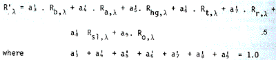
Assume that the response from these surface types does not change in the period between images acquired prior to ploughing, given response R1 l and subsequent to ploughing with response Rl. also assume that the relative proportions of these surface types does not change in this period so that:
Equation 8 consists of a set of m equations where data is acquired in m wavebands. For MSS data m = 4, and m = 7 for Thematic mapper data. These equations can be solved to determine a0, a1, a2 as the independent unknowns, by least squares, as long as the four nodes of response Rp, l, Rg, l and R1 l form a tetrahedral space within the m dimensional data response domain (McCloy 1977a). mathematically this means that the normal equations must not be singular.
Because of the great difference in response between the flooded paddy field and the other surface types, it is best to solve equation 8 as soon as possible after ploughing so that a1 and a2 can be assumed to be zero.
For all subsequent image a1 can then taken as constant so total equations 8 will contain only three unknown, a0, a1, a2 and of these
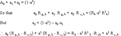
and equation 11 can be solved by least squares methods as long as the normal equations are not singular.
Conclusion
A methodology has been described to map the extent, and monitor the condition of rice crops. The accuracy of the results achieved are primarily dependant upon the accuracy of the rectified imagery, the validity of the hypothesised canopy reflectance model, and the assumptions of constancy of response and proportions of non paddy surface types within the pixel.
A number of workers, (McCloy 1977b)), Fleming (1999)) have achieved standard errors of about half a pixel in positioning MSS imagery and Forester (1980) reports achieving accuracies of ± 30 metres standards error. Clearly the higher the accuracy that can be achieved in rectifying the imagery, the more accurate will be the analysis of change in response from one image to the second.
The validation of the canopy reflectance model can be evaluated under experimental conditions. The assumption of constancy of response, is, however a practical problem, the significance of which increase as the proportion of the pixel that is covered by these surface types increases. It may therefore be necessary to provide an upper limit to a1 after which the pixel will not be considered to contain paddy field. Clearly in these conditions, the smaller the size of the picture element then the more accurate will be the final estimates of both paddy field area and condition. Technically therefore the Thematic Mapper must provide better estimates of area and condition than will be the Multispectral Scanner.
References
- Badhwar, G.D., 1980, “Crop emergence date determination from spectral data”, photogrammertic Engineering and Remote Sensing, Vol. 46, No. 3 pp. 369-377
- Fleming, E.A., 1977, “Positioning offshore features with the aid of LANDSAT imagery”, photogrammetric Engineering and Remote Sensing, Vol. 43, No. 1, pp. 53-59
- Forster, B., 1980, “Urban control for LANDSAT data”, Photogrammetric Engineering and Remote Sensing, Vol. 46, No. 4, pp 539-545.
- Horwitz, H.M., Nalpka,R.F., Hyde, P.D, and Morgenstern, J.P., 1971, “Estimating the proportions of objects within a single resolution element of a multispectral scanner”,
- Proceeding, Seventh International Symposium on remote Sensing of Environment, Ann Arbor, Michigan.
- Kauth, R.J., and Thomas, G.S., 1976, “The Tasselled Cap – A graphic description of the spectral- temporal development of agricultural crops as seen by LANDSAT”, Proceedings, Symposium on Machine Processing of Remotely Sensed Data, LARS, Purdue University, Purdue.
- McCloy, K.R., 177 (a) “The Vector Classified”, Proceedings, Eleventh International Conference on Remote Sensing of Environment, Environmental Research Institute of Michigan, Ann Arbor, Michigan.
- McCloy, K.R., 1977 (b), “Geometric fitting of LANDSAT imagery”. Bullentin, Remote Sensing Association of Australia. Volume 3, No. 1, pp 6-19.
- McCloy, K.R., 1979 “Mapping grassland condition in the South East Region of South Australia”, Proceedings, First Australasian LANDSAT conference, Macquarie University, Sydney.
- McCloy, K.R., 1980 “ The Response characteristics of vegetation in LANDSAT MSS digital data”, accepted for publication, Remote Sensing of Environment.