| GISdevelopment.net ---> AARS ---> ACRS 1980 ---> Technical Session |
Application of remote sensing
in forest landuse planning.
Boonchana
Klankamsorn
Thongchai Charuppat
Royal Forest Department
Ministry of Agriculture and Cooperatives
Bangkok, Thailand
Thongchai Charuppat
Royal Forest Department
Ministry of Agriculture and Cooperatives
Bangkok, Thailand
Abstract
Foresters have recognized that forest is an integral part of the ecosystem and its occurrence, structure and growth are intimately linked with the physical character of the landscape. Management of the forest is actually management of forest land; in addition to the essential information on the quality and extent of forest cover, there is also a comprehensive knowledge of the physical characteristics of the land, past and present land use practices. Air-photos and satellite imagery have been used to map and assess forest land resources for the whole country. The results of the study indicated that in the twelve-year period (between 1961 and 1973) the forest area decreased approximately 3.2 per cent per annum. This high rate of deterioration is mainly due to population increase and political, economic and social pressures. Thailand has committee herself to maintain forest area at 40 per cent of the total land area. At present the existing productive forest area is about 25 per cent, the disturbed non-productive forest area is about 13 per cent of the total land area. It is important that those deteriorated areas be restored to be the productive forest area, watershed area, national park and wildlife sanctuary. One of the solutions to achieve the desired target of 40 per cent is be establishing forest plantation.
1. Introduction
For the past 50 years ago, almost 619,953 sq. kms. which make up the total area of Thailand, are covered with dense forests distributed all over the country except part of the great central plain where the forests had long ago retreated to give way to agricultural. The increasing of the population growth in Thailand during the last few decades has been at a relatively high rata of 3.0 per cent per annum. All existing bare ground has been exploited and never enough for agricultural purposes. This is the main cause of very large area of natural forests being encroached and occupied by the cultivators extensively. It is the fact that developing countries today are largely dependent on the national utilization of their national resources for economic growth. Most of such countries are becoming aware of the potentialities of natural resources in their socioeconomic development and in safeguarding the natural environment for the posterity. Therefore, many countries in the world try to preserve and manage their existing forest resources to be the best advantage.
Moreover, foresters have recognized that forest is an integral part of the ecosystem and its occurrence, structure and growth are intimately linked with the physical character of the landscape. Management of the forest is actually management of forest land, in addition to the essential information on the quality and extent of forest cover, also a comprehensive knowledge of the physical characteristics of the land, past and present land use practices. In order to locate and indicate what, where and how much of the forest resources need to be preserved and managed, remote sensing has been used for surveying and mapping to assess forest resources in Thailand since 1973.
Realizing that forest resources are directly and indirectly beneficial to the economic and social development of Thailand, the Royal Thai Government in the five-year National and Economic Development Plan-phase 4 for the period 1979-1981, set a policy of conserving 40 per cent of the total area of the country (207,982 km2) as a forest area. However, due to political, economic and social pressures, the forest condition has consistently deteriorated. This makes the set goal has not been reached. If we do nothing, within the next tow decades Thailand’s forestry resources will be so reduced as to cease making any economic contribution to the country. Therefore, there is an urgent need to use modern techniques of remote sensing for surveying and mapping the forest resources in order to solve all of these problems.
- General Physical Characteristics of Thailand
- Total area of the whole country of Thailand 519,953 sq. kms. Can
be divided in to five regions.
- The North is made up mainly of highlands and steep mountains surrounding fertile alluvial valleys.
- The Northeast comprises a generally low-lying zone, plus the Korat Plateau.
- The Central region constitutes the Chao Phraya Plain around Bangkok.
- The East consists largely of a broad coastal zone, with a hilly hinterland.
- The South comprises of long narrow peninsula extending towards Malaysia.
- The Forests of Thailand
- The forests of Thailand may be classified into the following
types.
- Tropical Evergreen Forest
- Mixed Deciduous Forest
- Dry Dipterocarps Forest
- Pine Forest
- Mangrove Forest
Besides, there are other two minor types namely the Beach Forest consisting of Casuarina species and other Calophyllum and Hibiscus species. Then there are the Swamp Forest in which the grown small trees like Hydnocarpus, Xanthophyllum, Albizzia and Butea species.
The forest in the Northern Region of Thailand are of Teak (Tectona Grandis Linn) bearing type. The forests are rich in timbers of commercial value and also found various minor products of economic value such as bamboo, rattan, wood oil, gums and incense wood. Most of the forests are Tropical Mixed Forests with many valuable species. This type is very dense with considerable understoried plants and climbers, making ground inventory completely inaccessible.
All forests are state’s ownership, Royal Forest Department under Ministry of Agriculture and Cooperatives is responsible for managing this valuable resource.
- Reasons for Using Satellite imagery which make it useful in
forestry are:
- (1) The LANDSAT-Imagery has seven different wavelength bands simultaneously. The images from different bands can be used separately or in combination (visual comparison or computer composite) to give the clearest picture of the details of interest.
- (2) Complete coverage of the earth every 18 days allows continuous monitoring of the variables of interest. Also, in the case of Thailand the entire country can be covered by only 40 photo frames.
- (3) The data processing systems of LANDSAT are specifically designed for high altitude photography. The imagery has good resolution even though it is taken from a height of 914 kilometers.
- (4) Each frame of a LANDSAT imagery covers an area of 185 x 185 kilometers (34,225 km2) in size. This allows study and comparison of large areas; up-to-data can be obtained quickly and easily.
- (5) Satellite imagery can be computer processed. Different bands can be combined into composite color photos and maps can be drawn by the computer. This method yields much detail, but may be expensive for small areas.
- To identify and study the changes in forest areas in Thailand.
- To produce maps showing existing forest area from LANDSAT imagery.
- To make available data which will aid in the future study and forest land use management planning.
- To select areas for forest plantation.
- Photographs. Black and white satellite imagery, scales 1:500,000 and 1:250,000 band 5 and band 7
- color Composite Transparency film, scales 1:1,000,000
- Base Maps. Topographic maps, scales 1:250,000 and 1:50,000
- Drawing Equipment. Plastic Transparencies, pens etc.
- Equipment for Field Checks
- Magnifying glass
- Tape measure
- Compass
- Data recording sheets
- 35 mm. Camera for photographing ground sites
- Vehicle
Office work
All imagery were interpreted, and preliminary maps drawn, before doing any field verification of imagery data.
Planimetric details from a topographic map (scale 1:250,000) were transferred to a plastic overlay. This was overlaid on the imagery (1:250,000 print) for ground control.
The details of interest for this study were forest areas, deteriorated forest areas, and non-forest areas. Boundaries were delineated simply by tracing details on to a transparency overlaid on the imagery. Prints of Band 5 and Band 7 were interpreted separately, but it was often helpful to compare the prints each other and with the color diazochrome films positive.
2 Field work
Imagery interpretation must be verified by ground checks. Because of the large area involved it was, of course, neither possible nor desirable to check everything. Point sampling was therefore used. Points were selected for checking by simple random sampling.
The land classification delineated on the preliminary map (see 4.1) were used as strata. Points were selected for field check by simple random sampling within strata.
At each of field check point, a 100 x 100 meter square plot was laid out. The general characteristics of this plot were assessed and compared with the interpretation of the satellite imagery.
Observations were recorded on a ground check data sheet. This sheet has two parts : one for recording the details of the imagery (tone, texture, etc.), and one for recording the general characteristics of the ground site.
All of the data collected from ground truth were used for correcting the primary map to make the forest map showing existing forest in Thailand.
Results and discussions
From LANDSAT-1 imageries (taken in 1972-1973) with some ground checks in 1974-1975, it was found that forest area of the whole country has been extensively depleted and decreased to approximately 38 per cent by 1973. comparing the forest area from photo-interpretation data in 1961 against the LANDSAT-1 data in 1972-1973, the results shows that within the past 12 years the forest areas has been encroached and deteriorated for about 3.2 per cent or 6,073 km2. per annum.
At present, by interpretation of LANDSAT-2 imageries (taken in 1977) black and white band 5 and 7 at a 1:1,000,00 scale, the existing forest area in Thailand 38 per cent can be classified as
- The existing productive forest area is about 25 per cent.
- The disturbed non-productive forest area is about 13 per cent.
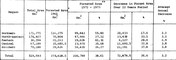
Source : Areial Photographs , photographed in 1961
Source : Land sat-1 imagery, photographed in 1972 - 1973
Remark : Some areas were covered with cloud, interprethation that areas cloud no be condcted.
& :"Forested Area" include managed and unmaged forest. forest plantaions, and forset in or near villages.
5.1 Rate of Deterioration of Forest Area
Comparison of aerial photograph taken in 1961 with satellite imageries taken in 1972-1-73 shows that
- The Central and the South had the highest annual deterioration rate at the same 3.0 per cent.
- The Northeast had the annual deterioration rate at 3.2 per cent.
- The East had the annual deterioration rate at 2.9 per cent.
- The North had the lowest annual deterioration rate at 2.2 per cent.
- The increasing of the population growth in Thailand has been at a high rate of 3 per cent per annum.
- Due to the population increase, the badly need of land for food
products are getting more and more and leads to the high pressure on
land requirement for their living and investment.
In case of invaders on forest trepass, it can be classified by characteristic into 4 main groups which are:- Migrated people from neighbouring countries.
- Capitalists who sent their laboratories open the fertile forest land.
- Indigeneous people, especially the poor farmers who do not have enough land and hired farmers who have no land of their own.
- Demand on timber is much higher than forest supply. In 1972, FAO had studied on the supply and demand from forest resources in Thailand. The results shows that at present a deficit of annual cut over growth has occurred.
- The weakness of forest low.
- Royal Forest Department has not enough forest ranger and financial support for forest protection program.
- In the past, it has no forest development plan. Royal Forest Department carried out all functions as temporary solution just on the spot to the facing programs. But now, forest policy would have to follow “The Fourth National Economic and Social Development Plan’.
- Increasing in industrialization, the forests were destroyed for industry sites.
5.2 Existing Forest Compared with the National Target Figure
Thailand has committed herself to maintain forest area at 40 percent of the total area. This study shows that the existing forest area in three of five regions in Thailand are below this desired figure.
Table 3 shows that the forest area in the Northeast, the Central and the South are lower than the target area of 40 per cent by about 7,233 km2. Only the North and the East have forest area higher than the desired figure.
5.3 Selecting Areas for Plantation Establishment
It is important that those deteriorated areas be restored to be
- Productive forest area.
- Watershed area
- National park and
- Wildlife sanctuary
In looking for suitable sites for plantations, two types of areas must be considered.
1. Watershed Areas Realizing that the forest lands in the North are the watershed area of Ping, Wang, Yom and Nan Basin, which flow from the North to the central plain as Chao Phraya River. This river is very important for irrigation system of agricultural lands both in the North and in the Central.
In 1976, by using LANSAT imageries to assess the deteriorated forest areas in those basins, it was found that 9,146 km2 of forest areas on the steep terrain of mountainous lands were destroyed by hill tribes people. These hill tribes earn living by shifting cultivation for growing rice and other agricultural crops. Each devasted forest area by the hill tribes will be exploited only for 2-5 years depends upon the degree of slope. If the slope is too steep the area will be deserted very fast. After the soil quality getting very poor for growing food crops they will move over to encroach and clear fell another forest lands extensively in the form of shifting cultivation method.
Although total existing forest area in the North is higher than the desired target figure (Table 3). But the reasons as mentioned above, it needs to take a decision for re-planting on four of those basin areas.
2. Other Areas
It is impossible to re-plant only in the north, without re-planting in other areas. Other areas such as National Forest Reserve, National Park or Wildlife Sanctuary in other regions which were destroyed, they should be re-planted in conjunction with the watershed improvement program in the North. If we can protect the existing forest area at 38 per cent and re-plant 480 km.2 each year, we will reach the desired target of 40 per cent in 15 years.
As we know it takes a long time and a lot of budget but it is the right and the best thing that should be done.
6. Conclusion
Forests are one of the few renewable natural resources. With careful planning and good reforestation programs we can harvest timber indefinitely. The forest land-use should be planned in conjunction with the master land-use plan. From using remote sensing application for forest land-use planning, it was found that within the past 12 years the forest area in Thailand has been depleted and deteriorated at the high rate of 3.2 per cent or about 6,073 km2 annually. The results shows that total forest area of Thailand is lower than the desired target to maintain 40 per cent of the total area of the country as forest area. This indicates that Thailand’s forest has now reached and political, economical and social pressures. All of these pressures make the forest conditions in Thailand getting very worse and cause a lot of problem to be solved.
However, we can plant today for a future so far away. To remedy the situation of the total forest area of Thailand to achieve the desired target of 40 per cent, it is necessary to expand the forest plantation area by establishing forest plantation program. Moreover, the forest resources must be routinely monitored by using remote sensing as a useful tool in forestry on order to know exactly the existing forest area as an input to the optimum forest land-use planning.
References
- Krit Samabuddhi Forestry Development in Thailand. Royal Forest Department, Bangkok, Thailand, 1966.
- Praphat Saengsakul Working Progarmme of Royal Forest Department of Thailand on Land Rehabilitation and Resettlement. Royal Forest Department, Bangkok, Thailand, 1979.
- Manit Naiyanetra and Niwat Jatikanond Problems on Forest Deterioration in Thailand and The Efforts to Diminish this Crisis. Royal Forest Department, Bangkok, Thailand, 1978.
- Boonchana Klankamsorn Use of Satellite Imagery to Assess Forest Deterioration in Eastern Thailand. Royal Forest Department, Bangkok, Thailand, 1977.
- Boonchana Klankamsorn Et el. Use of Satellite Imagery to Assess Forest Deterioration in Ping, Wang, Yom and Nan Basin Royal Forest Department, Bangkok, Thailand, 1977.
- Boonchana Klankamsorn Application of LANDSAT-1 Imagery in Forestry Surveys. Royal Forest Department, Bangkok, Thailand, 1977.
- Boonchana Klankamsorn Forest Landuse Planning for Eastern Thailand. Royal Forest Department, Bangkok, Thailand. 1979.
- Boonchana Klankamsorn Studying and Mapping of Watershed Areas by Using LANDST Imagery. Royal Forest Department, Bangkok, Thailand, 1980.
- Dr. Sathit Et al. Wacharakitti The assessment of forest areas from LANDSAT imagery. Faculty of Forestry, Kasetsart University, Bangkok, Thailand, 1978