| GISdevelopment.net ---> AARS ---> ACRS 1980 ---> Technical Session |
Study of Sedimentation and
Watershed area around the Bhumibol reservoir with Remote Sensing
Technique.
Dr. Prasit
Prainmongkolkarn
Associate Professor
Chulalongkorn University
Dr. Chavalit Thisayakorn
Plant Manager
Panjaphol Fiber Container
Haan Kittichanon
Computer Technologist
Asian Institute of Technology
Kanya Jirapayoongchai
System Analyst
National Research Council
Associate Professor
Chulalongkorn University
Dr. Chavalit Thisayakorn
Plant Manager
Panjaphol Fiber Container
Haan Kittichanon
Computer Technologist
Asian Institute of Technology
Kanya Jirapayoongchai
System Analyst
National Research Council
Abstract
This paper presents various classification techniques for mapping the sedimentation and watershed area around the Bhumibol Reservoir using LANSSAT data. Mapping of the sediment which could not be identified by photo interpretation of false color composite and by conventional maximum likelihood classification technique was made possible by using the decision tree algorithm derived from the spectral characteristics of LANDSAT data in band 5 and 6 relating to sediment. Results of the two methods for classifying the suspended sediment in the reservoir, namely the decision tree algorithm and the maximum likelihood classification with the decision tree algorithm, were compared with that of sediment survey conducted by the Electricity Generating Authority of Thailand (EGAT) and found that they are in good correlation with coefficients of 0.68 to 0.75 respectively.
The Ping watershed area of the Bhumibol Reservoir was mapped and categorized into three levels of forests using the technique of photo interpretation of LANDSAT data obtained from LANDSAT-1 IN 1973 by the Royal Forest Department. Results showed that the Ping watershed area was destroyed by shifting cultivation approximately 0% of the total watershed area (26,262,50 sq.km,) in 1973 and 74% of the watershed area was still left as forest which was 19,627,50 sq.km.
A brief discussion on future applications of information on watershed area, land use patterns, and sediment derived from LANDSAT data to hydrologic model, sediment estimation, and other activity concerned with the reservoir management is also given.
Introduction
Watershed area is a n integral part of the ecology system which gives rise to streams, river, and reservoir providing water necessary for irrigating the cultivated land in the downstream and for hydro-power generation. Conservation of forest in the watershed area is therefore essential for keeping the whole ecological system in the Lasin working in a well-balanced manner. However, as a consequence of accelerated rural development in recent-year such as the construction of dams for power generation and roads accessible to the remote area where the watershed area of the reservoir is situated, forest in the watershed area has been rapidly depleted by shifting cultivation and by other man-made activities. This subsequently creates many problems due to imbalance of ecosystem such as flood, drought, soil erosion, and sediment discharge into the river which settles down in the reservoir around the dam.
Sedimentation of the inflow surficial water towards the reservoirs in Thailand is a serious concern as a degradation factor of the electricity utility generation. Life time of the Dam and reservoir usage will be shortened very rapidly in the reservoir receives steadily increasing sediment loads derived from stream basin. The ground observation of sediment and discharge on a basis of cross-section sampling method is very troublesome and time consuming over a large reservoir, such as Bhumibol reservoir with the approximated size of 300 square kilometers. LANDSAT data acquisition system with the multispectral scanner can collect the earth surficial information, particularly over Bhumibol Reservoir area in less than 20 seconds. The mapping and detecting of the sedimentation area with the LANDSAT data employed by computer processing techniques will be essential for reservoir maintenance purpose.
The objective of this paper is to apply remote sensing technique to map the sediment and forest of the watershed around the Bhumibol Reservoir and to utilize the information of sediment and watershed area derived from the LANDSAT data for better reservoir management.
Mapping Of Sediment Of Watershed Area
The sediment from the Ping river are deposited the reservoir between site 10 and the head of the reservoir over a least of some 60 kilometer (I) as shown in Figure I.
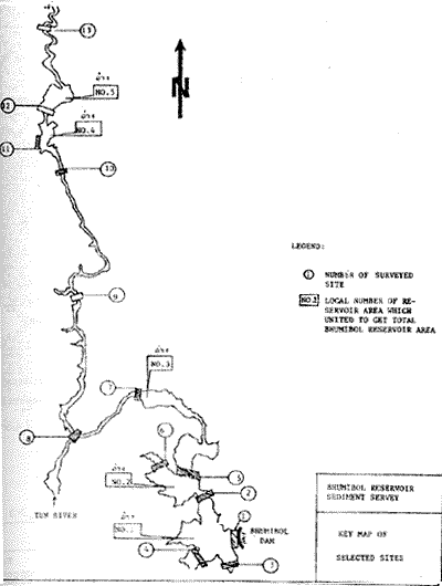
The Bhumibol Reservoir
However, using the spectral characteristics of LANDSAT data in Band 5 and 6 at the tip of Reservoir No. 2 as shown in Figure 2A, it is possible to distinguish the range of clearer water and turbid water in Band 5 and 6.(3). Thus a decision tree algorithm was devised with combination of graytone level of each pixel in Band 5 and 6 in the Reservoir as shown in Figure 2B. The classification map of sediment using the decision tree algorithm in the Reservoir No. 4 and 5 are shown in Figure 3(b) . from the classification map of Figure 3 (b) , maximum likelihood classification was applied as shown in Figure 3(a) to give better results. Comparison of results obtained from the two classification methods described with that of sediment survey by EGAT showed that they are in good correlations of 0.68 and 0.75 respectively.
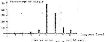
Figure 2A. Histograms showing the frequency distribution of data in band 5 (a) and band 6 (b) at the lower tip of Reservoir 2.
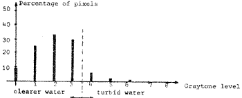
Figure 2B Decision Tree Algorithm.
Watershed Area
LANDSAT red and reflective infrared images and false color composites were used to delineate the forest area in the Ping watershed by the Royal Forest Department and the map obtained was spot checked to ensure the accuracy of the map . (2). For purposes of watershed management classes of land cover are defined. Class 1 is cover is predominantly tropical evergreen forest located on higher and steeper slopes that has experienced little cutting and is assigned officially as forest protection area. Class 2 is also dominated by tropical evergreen forest but may also contain dry dipterocarp and is located on lower slopes and has been heavily cut. Class 3 land is mostly deforested. Table I shows the extent of land cover classes in the Ping watershed reported by Hr. Boonchana Klankamsorn of the Royal Forest Department, Thailand.
| River | Class 1 | Class 2 | Class 3 | Total Area |
| Ping | 15,371.25 | 3,116.25 | 4,775.00 | 26,262.50` |
Table ii. Forest area ----------------- watershed (sq.km.)
| River | Total Area | Hor Forest area | Forest area destroyed by shifting cuyltiva | . Forest left |
| Ping | 26,262.50 | (100%) 5,027(19.14%) | 1,808(8.12%) | 19,627.50(74.74%) |
Table II shows the forest area in the Ping watershed derived from LANDSAT –1 and LANSAT –2.
Results and Discussions.
It is hoped that the digital mapping of sediment can be further refined to classify sediment in quantitative number of ppm and could be applied to map the suspended sediment in other reservoirs correctly by constantly testing and refining the classification capability until certain level of reliability is attained.
A correct and fast mapping of the sediment and watershed area would be enable the reservoir manager to calculate the hydrological model based on the LANDSAT data such as that developed by the Soil Conservation Service (SCS) and STORM (Storage, Treatment, Overflow Runoff Models) on the other hand, if the watershed area of the Bhumbol Reservoir is monitored by its change of land use pattern and area, and if the annual depth of erosion in mm. Can be obtained from the test sites, the quantity of sediment inflow to the reservoir annually can be calculated by simply divide the annual depth of erosion by the average watershed area.
Maximum likelihood classification which has been proved successful in mapping the forest area in the Eastern Region of Thailand (4) can be introduced to map the Ping watershed area easily and hence giving more exact quantitative number of the watershed area.
Acknowledgements
This research was financially support through the grant by the National Research Council. Its success depends heavily on the close co-operation and advice by Nr. Vibulsresth, Director of Remote Sensing Division, National Research Council in providing facilities and LANDSAT materials for this research. The authors wise to express sincerest gratitute for him.
References
- Report of Sediment Survey of the Bhumibol Dam, Report No. 842-2108, Electrician, Generating Authority of Thailand. April 1978.
- Boonchana Klankamsorn, “Applications of LANDSAT imagery to the forest activities”, Report of third training on remoter sensing techniques, June, 1979.
- Prasit Prapinmongkolkarn, Chavalit Thisayakorn, and haan Kittichanon, “Digital mapping of sedimentation around the Bhumibol dam from LANDSAT data”, Final Research Report submitted to the National Research Council, 1979.
- Prasit Prapinmongkolkarn , Chavalit Thisayakorn, and Kanya Jirapayoongechi, “Study of the change in area coverage of forest in a period of 3 years using computer analysis of LANDSAT data”, Final Research Report submitted to NRC, 1978.