| GISdevelopment.net ---> AARS ---> ACRS 1980 ---> Technical Session |
Land Use Classification Using
Landsat Data.
Manu Omakupt
Valairat Vunpiyarat
Land Development Department
Ministry of Agriculture & cooperative, Thailand
Valairat Vunpiyarat
Land Development Department
Ministry of Agriculture & cooperative, Thailand
Abstract
Landsat 2 multispectral scanner was used to investigate land use patterns in the north Thailand. Computer-implemented pattern recognition techniques were applied for digitally processing and analyzing Landsat 2 multispectral scanner data. Using reformatted digital data obtained by satellite scanner on 1 February 1977, 15 training areas of known features in the Chiengmai River Basin were selected. Ground observations on exact locations for training of the computer were required. Then the spectral statistics of 15 training areas were carefully examined and correlated with ground observation data. After the statistical parameters had been determined, the maximum likelihood algorithm was utilized to classify the entire data set. Results of the analysis showed that 11 land use categories in the study area could be classified with a high level of accuracy. Supervised technique was judged to be the most accuracy for agricultural mapping in the flat terrain while urban land use mapping was considered to be sophisheterogeneous nature and continuous nature of the urban surface cover. However, this study indicated that several level II land use categories could possibly be identified from satellite data.
Introduction
Since the launching of the first satellite in July 1972, remote sensing has become acceptable by most geoscientists for use in identification, mapping, and management of natural resources. With increasing demand for agricultural products, more intensive management will be needed to increase yield. The technological advancements should better meet these needs (Beaubien , 1979). Attention now turns from conventional aerial photography to small-scale photographs taken from aircraft at high altitudes or from satellites. Because the satellites sense reflectances of a given portion of the earth regularly (at 9 or 18 day intervals) in four bands of the electromagnetic spectrum, they also provide the necessary information for multitemporal analysis. Several researches have studied the potential of these MSS data for natural resources inventories . shimabukuro et al . (1980) studied the potentiality of computer aided processing of Landsat data to classify tree species in Brazil and concluded that the automatic classification could be done effectively in remote regions, where ground and aerial surveys were often costly. Hoffer (1976) also conducted the computer-Aided analysis of Skylab Scanner Data for land use, forestry, and water resource mapping and got a level of classification accuracy.
Mausel et al. (1976) classified an urban area into its board land-use classes using automatic data processing (ADP) techniques. The classification results suggested that all level I and many level II categories of the proposed U.S.G.S. land-use classification system were possible to identify accurately through machine-processing of Landsat multispectral data. Forster (1980) also mapped urban residential cover using Landsat digital data.
Much attention has been given to the identification and mapping of agricultural lands (which et al. 1979). He conducted that manual interpretation of Landsat images permitted the rapid construction of regional map products.
Objectives
The objectives of this study are as follows:
- To identify and map Chiengmai river basin into broad land use categories by digital analysis of Landsat MSS data.
- To evaluate the classification performance and obtain a quantitative
evaluation.
- Beaubien, J., 1979. Forest Type Mapping from Landsat Digital
Data, Photogrametric Engineering & Remote Sensing,
45:1135-1144.
- Feasibility Report 1970. Kud Reservoir Project. Royal Irrigation
Department, Bangkok, Thailand.
- Forster, PB.C. , 1980. Urban Residential Ground Cover Using
Landsat Digital Data, Photogrammetric Engineering and Remote
Sensing, 45:547-558.
- Hoffer, R.M., 1976. Computer-Aided Analysis of Skylab Scanner
Data for Land Use Mapping, Forestry, and Water Resources
Applications. LARS Information Note 060176, Purdue University , West
Lafayette, Indiana.
- Hoffer, R.M., 1976. Techniques and Application for
Computer-Aided Analysis of Multispectral Scanner Data, LARS
Information Note 062276, Purdue University, West Lafayette,
Indiana.
- .Mausel, P.W., W.J. Todd, and M.E. Baumgardnar, 1976. An
Analysis of Metropolitan Land-Use by Machine Processing of Earth
Resources Technology, Satellite Data, LARS Information Note 031275
Purdue University, West Lafayette, Indiana.
- Shimabukuro, Y.E., P. Hernadez, Filho N.F. Kotter and S.C. Chen,
1980. Automatic classification of Reforested Fine and Eucalyptus
Using Landsat Data, Photogrammetric Engineering and Remote Sensing,
46:209-216.
- Welch, R., H. C.Lo, C.W. Pannell, 1979, Mapping china’s New Agricultural Lands, Photogrammetric Engineering and Remote Sensing, 45:1211-1228.
The Study Area
The Chiengmai *River Basin located in the Chiengmai, northern Thailand area was selected for study. The study area, is located between 18° 45'Nand 99ºE. The climate of the area is Tropical Monsoon with moist summer and dry winter. The average annual temperature is about 25.28ºC and mean annual rainfall 121.9 cm. The Ping River flow through the study area from north to south is the longest river in Chiengmai province and also in the nation. Bounded by the forest-covered Dan Lac Ranges, the study area occupies an area of 732 sq kilometre with an elevation reaching 308.1 metre. Within this area, most of the agricultural activities are found. Only three major land uses are present (Cropland, urban, and forest), but the combinations and percentages vary considerably in identifying land use patterns. Most soils, commonly found under irrigation, are poorly drained alluvial soils yielding an average of 3,075 kg/hectare of rice production. This area tends to be one of the most important vegetable producing area in the northern Thailand (figure 1)
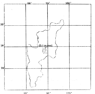
Locatio of the Study Area.
Method
Landsat scene ID No. D-2741-02510 acquired on February 1, 1977 was utilized for the study. Black and white imagery of MSS-5 and MSS-7 bands were printed at 1:500,000 scale for the test site selection. Landsat computer compatible tape (CCT) was subjected to be reformatted to produce an alphanumeric image of the study area. The grey scale images, produced for each of the four bands of MSS data, were then used in the drlrvyion og training areas , The RECOGX program, modified from the RECOG package of Co loralo State University by the Asian Institute of Technology (AIT), was used to carry out a supervesed classification for the entire study area. In the first stage, the locations of 26 known earth surface features, resulting in a total number of 15 training classes or areas, were designated to the computer system. A statistic processor containing in the program eas then requested. Consequently, a statistic processor provided a set of statistical parameters for each group of training areas. These parameters included the class mean, standard deviation, histograms, correlation matrix, spectral plots, and coincident spectral plots.
In order to judge these spectral values of 15 training areas, field checking was made in February 1980 to most of the areas accessible by road. In addition land use maps, previously made in 1977 from conventional aerial-photography interpretation, at 1:50,000 scale were also prepared so that all inaccessible training fields could be accurately located. Then the spectral statistics of 15 training classes were carefully examined and correlated with ground observation data. Taking into account the statistical parameters, 4 classes were considered to be less reliable . the remaining II classes were input to a Caussian maximum likelihood classifier which was used to classify all manually selected training areas and test sitd Computer classification results could be displayed in a maplike format or tabular output formats.
Results and Discussion
In the classification sequerce, each resolution element was assogmed to one of the spectral classes defined during the development of the training statistics. Based on the supervised classification results, a description of each of these II land use classes was presented below.
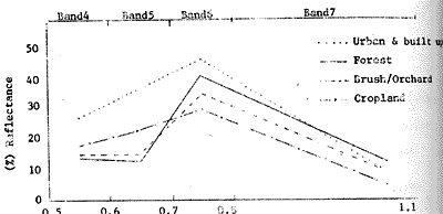
 Figute IV Reflectance values for a major land use classes for all
band combinations.
Figute IV Reflectance values for a major land use classes for all
band combinations.
FOD1 – Deciduous forests mostly dominated the Dan Lao Range along the west side of the study area. This class was considered as full canopy closure deciduous forest.
FOD2 – Partial canopy closure mixed deciduous forest
FOC1 – Full canopy closure mixed deciduous forest, exposed to sunlight.
FOC2 – Full canopy closure dry dipterocarps
OCHD – Mixed stands, predominantly dry dipterocarps or brush, with mature orchards and trees.
RFI1 – seedling –to-young rice of field crops including tobacco , peanut, soybean, mung bean corn garlic, and onion in irrigated rice fields.
RFI2 – Young rice or field crops including tobacco, peanut, soybean, mung bean, garlic, and onion in irrigated rice fields.
RFN1 – Non-irrigated, young to semi-mature field crops
RFNS – Non-irrigated, rice stubble or grass
UBP 1 – Transportation, communication, utilities
UBP 2 – Suburban, other
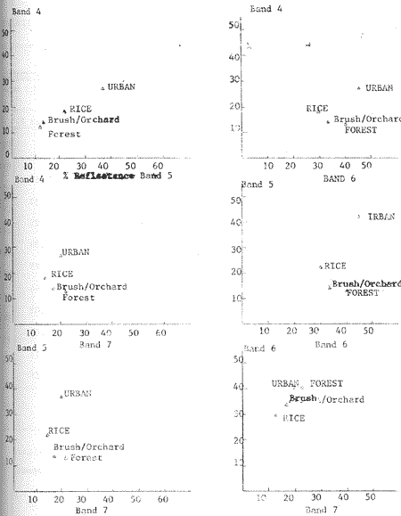
Summary of spectral statistic of these II land use classes was shown in Table 1. The supervised classification allowed us generally to distinguish forest, crop, and urban land. Spectral reflectance curves derived from the training data statistics for the four major land use classes indicated good separability of land cover and land use classes (Figure 2). Because a right portion of the Chiengmai River Basin is relatively flat, with a fairly simple vegetation cover, this no doubt contributes to the success of the classification.
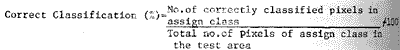
From Table 1 the spectral statistics revealed that identification of forest types was quite possible. Those were 3 subclasses of mixed deciduous forest and 2 subclasses of dry dipterocarp or deciduous dipterocarp represented FOD 1, FOD 2, FOC 1, FOC 2 OCHD , respectively. To obtain the classification accuracy, the percentages of correct classification were calculated by using the following formula
Thus, the overall accuracy classification of forest subclasses was between 85 and 100 percent, depending on the complexity of the area (Table 2). Areas with more homogeneous forest cover exhibited high classification accuracy. Apart from type differences, the major factors contributing to misclassification were density, soil moisture, high relief, and exposure of slopes. Areas exposed to sunlight (FOC 1) and contained dense canopy closure (FOD 1) and a higher reflectance than those with partial canopy closure and their associated shadow areas (FOD 2). The highest percentage of correct classification was obtained from the class FOC 1 (100 percent). This could be explained by the fact that class FOC 1 being trained to the computer was quite small and sufficiently homogeneous. For the area showed up with more variation (OCHD) the accuracy was lower than all the above-mentioned forest classes. However, the results showed that a supervised classification is proved to yield a very good results although some authors, including Beaubien (1979), and Hoffer (1976), claimed to achieve better results with an unsupervised classification.
Like the forest class, the classification accuracy of cropland class could be obtained in the same manner (Table 2). The first three subclasses were distinguished and characterized by irrigated water in the areas. Based on crop calendars, rice and some field crops were grown in these irrigated lands (Figure 3). Since most irrigated lands occurred in the study areas , the contrast between irrigated cropland and surrounding dry land was great the principal aids to identification of crops included crop calendars and reflectance differences between crops. Figure 3 indicated that identification of specific crops was handicapped by the overlap in the growing seasons. Because fields were still in early stages of growth with the exposed underlying water, the reflectance curve of cropland differed apparently from typically normal curve.
The fourth field (RFNS) was grass and recently cutting crops with the exposed underlying soil modifying the normal reflectance curve for green vegetation. Variations from typically spectral curve caused decision making on green vegetation class to be difficult. The benefit of ratioing could help the authors to make such decision. So the reflectance values for major land use classes were graphed in Figure 4 showing all possible two dementional combinations of the four bands. The quite high correlation of the two visible bands an the two infrared bands was clearly evident. Theoretically, the green vegetation would give a visible/IR reflectance ratio value of less than 1.0. This could be explained that the underlying water had a mare pronounced effect on the spectral values of vegetation class were considered to be density, stage of growth, flooding, drainage patterns, and locations.
Finally the urban and built-up land was sub divided into 2 subclasses, namely UBP1 and UBP2 the class UBP1 was predominantly a mixture of airfield (concrete), roof tops, and green vegetation. The combined spectral response from the various proportions of all phenomena permitted the differentiation of one urban class from another. The UBP2 class was primarily a mixture of rather highly reflective materials i.e. concrete and dry bare soil. Urban residential area typically exhibited heterogeneous nature of the urban surface cover. Another related problem which limited more detailed classification was the continuous nature of the cover classes. In UBP1 class residential density was high with few established large trees, another had similar density with no vegetation. Between each of these, intermediate example occurred (Forster, 1980). Thus the classification accuracy of urban classes ranged from 66.7 to 8.9%.
Conclusion
Analysis of Landsat MSS data from the February 1,1999 shows that the supervised technique can be used effectively to distinguished cropland, urban, and forest land. The overall classification accuracy is 93. 2% Classification of cropland proves feasible through the use of computer assisted classification procedure conducted with the aid of crop calendars and reflectance spectrum. Four crop categories can be identified. Crop type is detectable with difficulty owing to the confusion of irrigated water presented in the fields.
This study shows that data obtained by Landsat can provide information needed for a general mapping of forest and urban land. Mapping of the level II category is accurate but not always immediately discernable. The production of land-use maps has become a relatively simple matter with the recent wide availability of satellite data. Present satellite data are useful primarily for level I mapping.
References cited - Beaubien, J., 1979. Forest Type Mapping from Landsat Digital
Data, Photogrametric Engineering & Remote Sensing,
45:1135-1144.