| GISdevelopment.net ---> AARS ---> ACRS 1980 ---> Technical Session |
The accretion of mudflat in
the PANG-NGA bay form Landsat data
Absornsuda
Siripong
Marine Science Departement, Faculty of Science Chulalongkorn University, Bangkok 5, Thailand Nissai Sriplang Thailand Institute of Scientific and Technological Research, Bangkhen, Bangkok 9, Thailand
Shunji Murai, Ryuji Matsuoka, Ryutaro Tateishi
Institute of Industrial Science, University of Tokyo 7-22 Roppongi, Minatoku, Tokyo 106, Japan
Abstract
The distribution of mudflat in the Pang-nga bay was interpreted form 3 methods: area measurements form navigational chart, form Landsat imagery and form Landsat MSS CCT data. Studying the relationship between the surface suspended sediment concentration, the surface current and the water depth at 9 stations in the bay during the 2 monsoon seasons revealed that, generally the sediment concentration was highest at the strongest ebb current (positive direction) form river to sea. This means that the source of sediment in the Pang-nga bay is mostly form the river especially form tin mine sludge dumping. The net concentraion was in the direction of ebb current so that the accretion was in the seaward direction. This evidence can be seen form all 3 mudflat distribution results, especially form the major rivers to the inner part of the bay. The average concentration of the surface suspended sediment per tidal cycle in the southwest monsoon season was more than in the north east monsoon season. The high rateof sediment accreation will cause a severe problems later especially on killing the benthos and mangrove forest as occurred at Sapum in Phuket province and on the difficulty in navigation.
Introduction
The Pang-nga bay is on the Andaman seacoast of southern Thailand. It is rather a shallow bay especially in the inner part where the average depth is only 3.67 meters. There are 2 big islands, ko yao noi and ko yao yai along the median line and divide the outer water part of the bay into 2 parts: the Pang-nga bay on the western side with average depth of 8.85 meters and Luk bay on the eastern side with average depth of 12.85 meters. Form the outer part of the Pang-nga bay, there is a main inlet to the Andaman sea called Chontg Pak Pak Phra whose average depth is 4.51 meters.
Geomorpolgically, it is a submetgent coastline.Evidence of submergence is provided by drowned river courses in the bay and extensive mangrove forest on the shore. The shape of the western part of the bay has been partly controlled by a major NNE-SSW trending zone of faulting. Garson and Mitchel (1970) suggested that this fault zone appeared in Late Jurassic times. This area is a well productive of tin in Thailand and dumpintg of sludge form tin mining is one of the major causes of high accretion of mudflat in the bay.
Methods and Results
From the definition by Russell (1969), the mudflat is the deposit of ooze, clay, silt, etc., to water level along a shore. If tidal range is appreciable, the flat is ordinarily submerged at high tide. Also, similar deposits elsewhere, as along stream banks or in lower parts of basines. The mudflat is usually easily seen at the stage of low tide. However, sometimes we get the rather good Landsat data at the stage of high tide; form the experience in the field, the high concentrating of sediment form this type of data can be interpreted as mudflat in most case where the tidal current is not strong.
From the above criterial of defining the mudflat we study the distribution of it and the relationship between the surface suspended sediment concentration and surface tidal current during the two monsoon season at nine stations in the bay as follows:
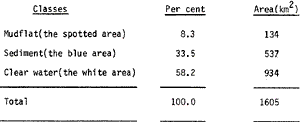
- Using planimeter measure the area of the following classes of
mudflat on the navigational chart published in July 1976. Natural scale
1:200,000 at latitude 10° N, Mercator Projection.
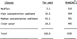
- Manual interpretation form LANDSAT imgery on 21 January 1979, local
time 9.49 a.m., scale 1:250, 000. The lowest predicated tide at ko
Taphao Noi, Phuket Province on that day was at 09.00 a.m. The procedure
was using imageries band 6 and 7 for mudflat classification (the light
gray area on black and white imagery) and using band 4 and 5 for
classification of the high and low sediment concentrations (the white
area). By weighing on a fine scale and later convert ot area and
measuring the area by using planimeter together in band 5. The measured
areas of the following classes of mudflat are:
- Using LANDSAT MSS CCT data on 2 March 1973 and classified the
surface suspended sediment based on histogram of group[ of the training
sets into 4 classes:
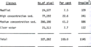
For the detail of the procedure, see Siriong et at. (1979). The image output (Plate 1) was form ALPHA LSI 4130 NAC mini-computer and TV monitor at Murai Laboratory, University of Tokyo.
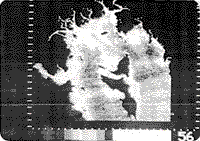
Plate 1. Surface sediment classification in the Pang-nga bay form Landsat MSS CCT on 2 March 1973 about hi
- From selected 9 stations in the bay collected seawater at the
surfacee for analysis the concentration of surface suspended sediment
using standard method and compute the concentration into mg/1 ; measure
the surfacec current using current meter and computer U form

Where U0 is the resultant velocity form the current meter
q is the angle of current form the north form the current meter
a is the angle of the channel for the north
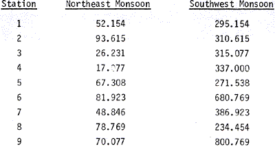
Measure the water depth. All of these measurements were done at each hour complete semidiurnal tidal period, and plotted all the data in Fig. 2.
Discussion
- Generally, the surface suspended sediment concentration was highest at the strongest ebb current. At some stations which have many inlets, the deviation form this pattern was observed. However, this indicated that the ebb current caused the maximum concentration of sediment.
- When comparing the sediment concentration during the flood and ebb
periods, we found that the content was higher in the ebb than in the
flood period which means that the source of
Fig 1. The 9 oceanographic stations in the Pang-nga bay.
Fig 2a. The variations of longitudinal current (U), sea surface suspended sediment concentratin and the water depth at 9 stations in a tidal cycle in SW monsoon.
Fig 2b. The variations of longitudinal current(U), sea surfacce suspended sediment concentration and the water depth at 9 stations in a tidal cycle in NE monsoon.
Fig 3. The distrubution of mudflat form Landsat imagery bands 4,6, 7 on 21 January 1979 about low tidal stage.
Sediment is rather form land runoff.
- During the highest and lowest stages of tide, when there was no
current or minimum current, which is the typical of the standing tidal
wave, the sediment concentration was low.
- The average surface suspended sediment concentrating per tidal cycle
was higher in the southwest monsoon season than in the northeast monsoon
season.
- The accretion of mudflat was rather high especially form the major with tin mine along their sides.
Garson, M.S. and A.H.G.Mitchell, 1970 , Transform Faulting in the Thai Peninsula, Nature, V.228, Oct. 3, 45-47.
Russell, R.J., 1969, Glossary of Terms used in Fluvil Deltaic, and Coastal Morphology and Processes, Louisiana State University Studies, Coastal Studies Series Number 23, 97 PP.
Siripong, A. S. Murai, R.Matsuoka, R. Tateishi and T. Okuda, 1979, Studying the Physiographic Feature, the Distribution of Suspended Sediment, Tin Mine and Mangrove Forest in the Pang-nga Area Utilizing Landsat MSS CCT Data, First National Seminar on Marine Science, 28-30 May The National Research Council of Thailand, Bangkok, 56 pp.
Acknowledgements
This is a part of the research project entitled “ The Esturarine Ecosystem of the Pang-nga Bay” 1978-1980, sponsored by the national Research Council of Tailand. The Japan Society for the Promotion of Science also granted a fellowship to the project leader to work on the interpretation of Landsat MSS CCT at the University to Tokoyo.
Mrs. Nongnat Setti, Surapol Tapananond RN, Thavorn Charoendee RN AND Sirichai Dharmvanij helped us for the gooundtruth data collection. Vinai Lertmahawong RN analyzed the sediment concentration. We are gratitude to the former and present governors of Pan