| GISdevelopment.net ---> AARS ---> ACRS 1980 ---> Technical Session |
River Discharge Monitoring
with the Aid of Remote Sensing
H. Shimoda, K. Fuku, T.
Sakata
Tokai Research and Information Center, Tokai University
Tokai Research and Information Center, Tokai University
Abstract
River Discharege patterns in Taisha Bay, Shimane Prefecture, Japan were studies by remote sensing. Natural color aerial photographs were taken at normal condition and a flood condition both with simultaneous sea truth measurements. At the latter case, taken photographs were oblique, and they were digitally rectified and mosaicked to make one image which include the whole discharge pattern. After certain preprocessings of the image, the clarity and the water depth patterns of the normal condition and the turbidity pattern of the flood condition were extracted by regression analysis with the aid of sea truth data.
Introduction
There are many kinds of applications in the field of remote sensing. One of those applications, but is rather new, is an environmental assessment with respect to specific construction. In this research, an impact to a fishing grounds in Taisha Bay will be caused by aconstruction of flood control channel was assessed with the aid of remote sensing.
Taisha Bay is shown in Fig. 1 and 2. There is a plan to construct a channel between kando River and Hi-I River in order
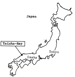
Fig. 1 Taisha Bay in Japan
Fig. 2 Kando River and Taisha Bay.
Investigations were done twice, one in a normal condition for comparison, and the other in a deluge condition. Natural color aerial photographs were used as remote sensors. Clarity and sea depth patterns were extracted at the normal condition, while turbidity patterns were extracted at the deluge condition.
Normal Condition
1 Data acquisition
Aerial photographs at the normal condition were taken on the 21, Aug, 1977. Table 1 shows the flight and sensor records. Sea truth measurements were done simultaneously with the flight. Measured items are a water temperature, a visibility a turbidity, suspended solids (SS), a water depth, a clarity and a reflectance. Fig 3 shows the positions of measurements.
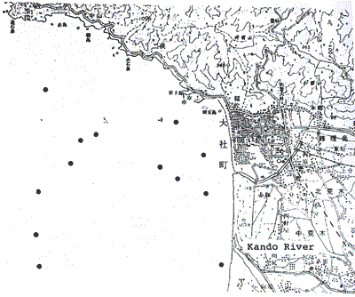
Fig. 3 The position of sea truth measurements at the normal condition
2 Image Analysis
Image analysis were made by TIAS (Tokai Image Analysis System) 2000. Fig. 4 shows the block diagram of TIAS 2000. Photographs were digitized through the TV digitiger. Geometric resolutions were 512 x 480 and radiometric resolutions are 8 bits for each principal colors, red, green and blue (R, G, B).
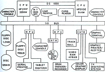
Fig. 4 A block diagram of TIAS 2000
Photographs have radiometric distortions which is caused by cosnq rule. In order to eliminate this distortion, the following equation was used.
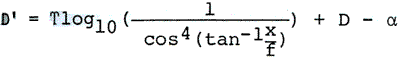
D’ : Corrected density
T : T-Value
X : Distance from the center of the image
F : Focal length
D : Density of original film
s : base density of the film
T-values were calculated with the aid of reflectance measurements, and are shown in Table 2 with values and the focal length.
Correlation coefficients were calculated between the sea truth data and waterdepths had meaningful coefficients. Results of single regression analyhsis for these two itesm are shown in Table 3. In this table, A and B denote the coefficients. Results of single regression analysis for these two items are shown in Table 3. In this table, A and B denote the coefficients of regression line y = Ax + B, while R’s are the correlation coefficients. Band to band ratios, B/G, B/R, and G/R were also used in the regression analysis in order to eliminate the radiometric distortions which was caused by caused by directional sun reflections.
As can be seen from this table, B/G values have sufficient correlations to clarities and were depths. Fig. 5 and 6show the results of the analysis.
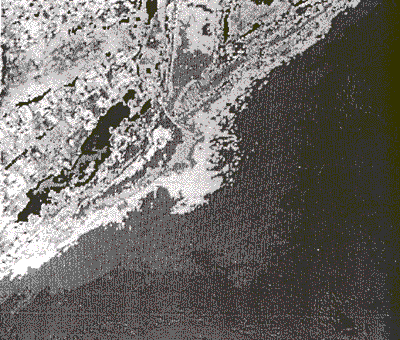
Fig. 5 Clarity pattern of Kando Reiver mouth at the norman condition
Deluge Condition
1. Data acquisition
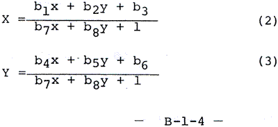
Aerial photographs at the deluge condition were taken on the 2, July, 1979. In this case, only a fairly low altitude photographs were taken due to the low cloud cover. Oblique aerial photographs were used as remote sensors in order to include as broad a field as possible even from a low altitude of 100~200m. The cameras and films used are shown in Table 4. Six photographs were necessary to cover the entire discharge pattern. A sample of these photographs is shown in fig. 7.
Concurrently with the aerial photography, several kinds of water characteristics were measured at 15 points in the bay. They are turbidity, ss (suspended solids), and a water temperature.
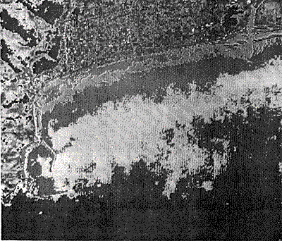
Fig. 1 Water depth pattern of Taisha Bay near the beach
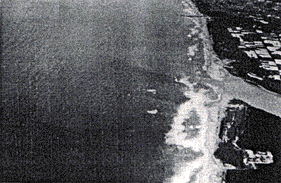
Fig 7. An example oblique aerial photograph taken at the flood condition.
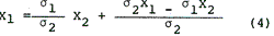
2. Digital rectification and mosaic
Three colour components (R. G. B) of the oblique aerial photographs were simultaneously digitiged through rotating drum digitiger with the resolution of 25 mx 25 and inputted to TIAS 2000.
The inputted images were first rectified to orthogonal projection images. Fig. 8 shows the flowchart of the geometric correction. Map coordinates of the ground control points (GCP) were measured by a tablet digitiger within 0.1 mm accuracy. Number of GCP’ are more than 10 points for each image.
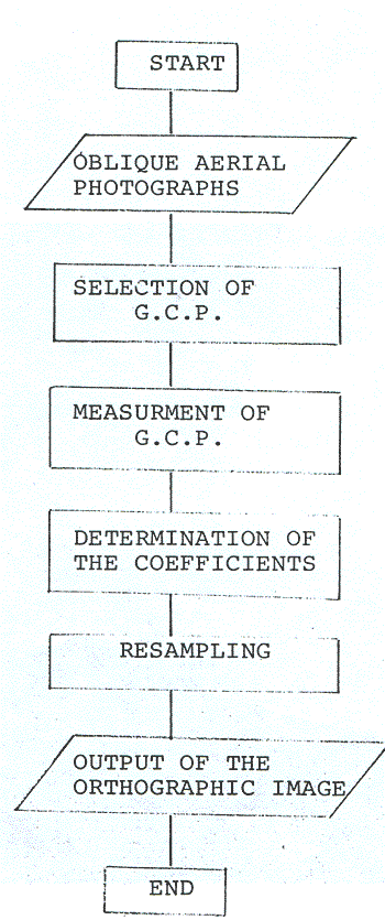
Fig. 8. A flowchart of the geometric correction.
Projection transformation as the following equations were used in the orthographic projection.
Here, x y denote the image coordinates, while x, y denote the ground coordinates. The values of the coefficients in the transformation equation were determined by the least square method with 10~15 ground control points for each image. The mean errors of these transformations were within 3 pixels. After projection transformation, orthographis images could be obtained by nearest neighbour resampling. Fig. 9 shows the rectified image of Fig. 7
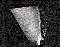
Fig. 9 The rectified image of Fig. 7.
In order to display the entire discharge pattern in single image, the images must be mosaicked, Even when aerial photographs are taken continuously, the density, colour tones and other factors will vary between the different images. There fore, it is im,portant to match the image density in producing a mosaic. It is also necessary to select seam points (connecting points of two images) in such a way that vertical and horizontal lines do not appear in the mosaicked image.
To obtain good density matching of the images, shadings (radiometric distortions) were deliminated first and then conversion was performed so as to equalize the mean and the standard deviation of densities in those of the overlapping areas between two images, which were designated by the operator. Density matchings were done by the following equation.
Here, x1 and x2 are densities, x1 and x2 are means, and s1 and s2 are are standard deviations of images 1 and 2, respectively.
The appearance of vertical lines was avoided by randomly selecting seam points, and horizontal lines were removed by means smoothing method. Fig. 10 shows the result of mosaic of 6 images.
Fig. 10 The mosaicked image of 6 oblique photograhs.
The mosaicked image was normalized according to the following equation in order to avoid the influence of directional sun reflection.
Here, Di is the density of each colour image, Ni is the normalized density, k is a constant, and suffix I corresponds to R, G and B.
A multi regression analysis was used to determine the relationship between these normalized densities and the turbidity. The resulting turbidity pattern in the bay was outputted as a color coded image as is shown in Fig. 11.
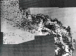
Fig. 1 The extracted turbidity pattern in the Taisha Bay from Kando River.
Conclusion
As a result of this study, the following conclusions were obtained.
- At a normal condition, the discharge of the kando River is very small and has almost no influence to the fishing grounds in the Taisha Bay.
- After the construction of flood control channel, the influence by the river discharge from the Kando River at flood condition will be restricted to a small amount.
- The water depth pattern along the Taisha beach and the clarity pattern near the kando River mouth were obtained at a normal condition.
- The turbidity pattern at a flood condition was clearly extracted.
- Water depth shallower than 10 m can be measured from a natural color aereal photograph when water is clear.
- Clarity or turbidity of the sea can be measured from a natural color aereal photograph with the aid of sea truth data.
- Rectification technique of oblique aereal photographs was established.
- Digital color mosaic techniques was established.
- With the above techniques, river discharge patterns can be monitored by fixed cameras, e. g. from the top of a mountain near the bay.
| Altitude | 1,500m |
| Reduced scale | 1/10,000 |
| Camera | RC-8 |
| Lens | Aviogon 152m |
| Overlap | 80% |
| Time | AM 8:00 – AM 9:00 |
| Film | Kodak Aerocolor Film 2445 |
Table 2 ¡, a values and focal length of the camera.
| B | G | R | |
| g | 0.188 | 0.332 | 0.285 |
| a | 0.20 | 0.10 | 0.27 |
| X | 153.62 | ||
Table 3 Regression snalysis results of clarity and water depth.
| Clarity | Water Depth | |
| 1 | - 7 m | 0 – 2m |
| 2 | 7 – 8m | 2 – 4m |
| 3 | 8 – 9m | 4 – 6m |
| 4. | 9 – m | 6 – 8m |
| 5. | _________ | 8 – 10m |
Table 4 Cameras and films used at the flood condition.
| Camera | Lens | Film | |
| 7/2 am | Mamiya press black 6*9 cm | Mamiya Sekor 100 mm F3.5 | Koda Color II C120 |
| Asahi Pentax ES 35mm | SMC Takumar 50 mm F1.4 | Fuji Color FII 135 | |
| 7/2 PM | Mamiya RB 67 6*7 cm | Mamiya Sekor 127 mm F3. 8 | Kodak Ektachrome 64 Professional |
| 7/3 AM | Canon AE 1 | Canon FD 50 mm F1. 4 | Fuji Chrome 100 RD |