| GISdevelopment.net ---> AARS ---> ACRS 1980 ---> National Report |
Remote Sensing Activities in
Thailand
Sanga, Sabhasri, Pradisth
Cheosakul
Boon Indrambarya
Suvit, Vibulsresth
National Research Council, Bangkok 9, Thailand
Boon Indrambarya
Suvit, Vibulsresth
National Research Council, Bangkok 9, Thailand
Abstract
The National Remote Sensing Program of Thailand was established in 1971 by cabinet decision as step towards peaceful uses of space technology. Thailand was later accepted by United States NASA to participate in Lanndsat-1, Skylab EREP and Landsat-2 investigation programs. This resulted in the availability of an up-to-date and accurate information required by various government agencies concerned with the planning for development and the management of natural resources at the national level. Landsat data have been applied in various disciplines including agriculture, forestry, land use, geology, oceanography, hydrology and environmental monitoring. The multidisciplinary nature of Landsat data has brought resources managers, decision-makers and technicians together in the joint-effort for common goal. Several projects hav e attained quasi-operational status. Research and development in digital processing of Landsat data in increasing although visual analysis of Landsat imagery still still occupies the major research and development effort. A new Remote Sensing Division was set up under the Natinal Research Council to cope with the increasing needs for user services and data analysis, to acquire facilities for direct reception and dissemination of Landsat data as well as to lend supports to other agencies in the applications of remotely sensed data. An airborne multiband photography project was initiated with partial assistance from UNDP and was intended for better management of agricultural/forest land use in the watershed areas. Co-operation with the United States, ESCAP and AIT resulted in the establishment of the Asian Regional Remote Sensing Training Centre at AIT. A Landsat/Metsat Receiving Facility is under development and is scheduled to be completed in autumn 1981 which would enhance the regional cooperation and technical exchange among countries in the Asian region.
Presented at the First Asian Conference on Remote Sensing, at the National Research Council of Thailand, Bangkok, on November 5-7, 1980.
Introduction
Most countries in Asia have been using conventional aerial photography for mapping purposes since some time before the Second world war, After the war ended in 1945 many coun tries realized the importance of and the need for aerial survey in making large scale maps and for national development planning.
With the launch of US NASA Earth Resources Technology Satellite (ERTS-1 later renamed Landsat-1) in July 1972 several countries in Asia joined the NASA sponsored Principal Investigators Program. In Thailand, the National Remote Sensing Coordinating Committee was appointed by the cabinet in September 1971 to coordinate the experimental efforts and to disseminate remote sensing information. The Commkittee has also conducted training workshops and seminars and performed coordination functions with NASA and other foreign and international bodies. The research and development activities are being accomplished by Working Sub-committees, the members of which are drawn from participating agencies interested in the program.
National Research Council (NRC) with the assistance of the United States Operations Missions to Thailand (USOM) AND THE us geological Survey, conducted a six week intensive training course in remote sensing during January-February 1973. This training served to acquaint, not only the Thaiuser agencies, but also scientists of the neighbouring countries, with the design philosophy of Landsat-1 and techniques of interpretation applicable to the small scale multiband imagery propduced by the satellite. This was followed, in May and June 1973, by additional consultation to the Thaiinvestigating team by members of the US experts. In may 1974, a sub-regional seminar on ERTS and Southeast Asia was organized by the National Research Council and the Applied Scientific Research Corporation of Thailand (ASRCT) with cooperation from USOM, US Information Service and NASA, Scientists from Indonesia, Malaysia, Singapore and Laos participated in the seminar to exchange information on the applications of remote sensing data, and to discuss with NASA experts on the latest development in sensors, system design and major applications in the US and elsewhere.
The second training workshop was held in January-February 1976 at the NRC/ASRCT and consisted of a Basic Part and an Advanced Part. The Basic Part was intended for beginners in remote sensing and was given by thai specialists. The Advanced Part was geared towards investigators who has basic background and some working experience with satellite imagery and given by the US experts. The latest seminar on applications of Landsat-2 data to national development planning was organized in June 1977 in which results of the Landsat Follow-on investigations were discussed. A workshop on automatic data processing of Landsat CCT’s was heldl at the Regional Computing Center of the Asian Institute of Technology (AIT) for Thai user agencies to acquaint themselves with the techniques of digital processing.
The training of personnel at advanced institutions, especially in the US also coccupied top priorities during the first phase of the program. More than thirty Thai scientists and technicians have undergone training in remote sensing in the US and elsewhere, including the workshops at EROS Data Center. Thailand has at present some eighty scientists and technicians engaged in fully time work on remote sensing and in in a position to cooperate with other Asian countries in joint research programs.
Applications of Landsat Data
Research and development projects in agriculture, forestry, land use, geology, hydrology, oceanography, cartography and environmental montoring were conducted mostly through visual interpretation of Landsat data with ground truth survey involving low altitude aerial photography and boat and car. Some of the significant results are:
Agriculture
The greatest contribution of earth resources satellite Landsat to Thiland is probably in agriculture. Landsat data c an assist in the differentiation of major agricultural crops, in the estimation of crop acreage, and later to yield forecasting. Moreover, Landsat data have demonstrated the effectiveness in damage assessment of crops resulted from drought, flood, storm and locust. Research work has also been conducted in crop calendar and practices, especially with emphasis on economic crops, in the assessment of paddy fields of the whole country and estimation of coconut and rubber plantation areas along the estern coast of Thailand and in some provinces in south Thailand, monitoring of changes in cultivated land. The Department of Agriculture has used Landsat imagery as base maps in many areas, with accomplishments such as the identification of active alluvial fans along the margins of the Central plain and the compilation of crop resources maps of Central and Eastern Thailand. Economic study has found that Landsat data are very cost-effective.
Forestry
Landsat data have been applied in the assessment of existing forest land, the identification of shifting cultivation and watershed areas, as well as areas of cut forest. The Royal Forest Department, in its country-wide survey of remaining forest cover using Landsat imagery of 1973 and ground truth survey found that, as a result of continuous clearing of forest land for agricultural purposes, the forest area in 1973 has decreased to 38% of total land area. Consequently a National Reforestation program was set up in order to increase the forest area to 40%. The cost-effectiveness of satellite survey has been established with Bht. 1.31 per sq.km. compared to bht. 33.44 per sq. km. For aerial survey, and with shorter time to accomplish the task.
Land-use
A large portion of the country has been mapped using Landsat imagery. The land-use classification using satellite data comprises the indentification of industrialized areas, agricultural arewas, water resource for agriculture, etc. The information obtained in used for resources planning, as an input to the improvement of Thailand’s economy. The cost-effectiveness of land-use mapping using Landsat imagery experienced by Land Development Department is at Bht. 0.32 per sq. k. compared to bht. 1.89 per sq. k. using aerial survey.
Geology
Experience to data has shown the many advantages of Landsat data over the conventional aerial photography in locating large faults and fractures and in the preparation of technic maps. Several rock types could also be identified from Landsat imagery. The Department of Mineral Resources conducted a study using Landsat imagery in examining evidence of turbidity in the coastal waters resulting from intensive tin mining operations. The study is a first step towards identification olf impacts on coastal environments resulting from mining and other activities.
Oceanography and Fishery
Remote Sensing provides information on potential fishing areas. Certain fish stocks may also be located by identifying their habitats on the imagery. In mangrove studies conducted in 1974 using Landsat data it was found that the mangrove area of Thailand weas 3,200 sq. km. The mangrove map was used to set up a plan for acquaculture of fish in coastasl areas and for the conservation of mangrove forest. The latter is regarded as beneficial to fishery because wangrove swamps are the habitat of sea larvae.
Data from the infrared band provide information on ocean circulation patterns, on coastal current structures and on other ocean features.
Repetitive coverage in coastal areas may by useful in determining major changes in rates of pollution, sedimentation and erosion.
Hydrology and Meteorology
Hydrologic information acquire from satellites is very useful to water resources management. It has practical value for the planning, design and operation of water resources projects for various practical purposes, such as the improvement of irrigation systems.
Monitoring of floods and assessment of flood damage can be assisted by Landsat data and real-time data will be neded for flood forecasting and flood warning, Meterological satellites such as Tiros-in and GMS provide such necessary real-time data.
There are about 29 agencies that utilize satellite data in their investigations. Major users come from: Royal Forest Department
Land Development Department
Department of Agriculture
Office of Agricultural Economics
Department of Mineral Resources
Royal Irrigation Department
National Environmental Board
Present Status
A national remote sensing user service and coordination center was established at the National Research Council to carry out administrative works and coordination functions of the national corrdinating committee and to provide user services in photographic reproduction of Landsat imagery and to lend interpretation equipment and facilities to user agencies. The Center was later reorganized as the Remote Sensing Division under NRC of the new Ministry of Science, Technology and Energy. There is a small technical library and a newsletter is being issued every three months. Research grants totaling US $ 50,000 are being provided each yar to various agencies concerned with the applications of remote sensing data. International cooperation, aside from that maintained with the United States, was initiated and NRC at present has cooperative research programs with France and Japan Similar projects are being planned with ASEAN countries.
A six-week training course and a five-day seminar are being organized as a annual program. About forty participants from government agencies and educational institutions would be trained in the techniques for interpretation of Landsat data. The seminar is intended to provide a forum for researchers to exchange experience and ideas and for discussion of research results, as well as to keep the government circles informed of the latest development in remote sensing. Training in automatic data processing has been initiated.
At present there are six universities which offer courses in remote sensing both at graduate and undergraduate levels. A plan to prepare a manual for interpretation of remote sensing data is proceeding satisfactorly
Current research and development projects include:
- The application of machines processing to plant acreage assessment and yield forecast of major crops such as rice, sugar cane and corn.
- The application of Landsat imagery to water pollution studies of Maeklong estuaries and Sri Racha Bay.
- The study of the relationship between the soils and the geomorphic features.
- The use of satellite imagery to study changes in forested area using both manual interpretation and digital processing.
- Mapping of agricultural land use patterns using Landsat data.
- Research and development on the preparation of Landsat false color image map and Landsat image format map.
- Use of satellite data to map geologic structure of Thailand.
- Study of environmental change in the Bangkok Metropolitan area.
- Remote sensing of geographic distribution of mineralization around Chiangmai Basin in north Thailand.
- Measurements of reflectance characteristics of natural resources of tropical countries, such as rice, corn, sugar-cane, cassava, etc.
- study of soil erosion due to incorrect agricultural practices.
- Development of a system hardware to process Landsat digital data in a interactive mode.
Photointerpretation of Landsat imagery has been practise in Thailand for more than seven years. Four years ago a conclusion was reached concerning the machine processing of Landsat data in Thailand. It was felt at that time that enough experience had been accumulated on the visual analysis and consideration should be given to acquiring the automatic data processing capability in Thailand. At the same time AIT received a research grant from the Committee for Coordination of Investigation of the Lower Mekong Basin (Mikong Committee) to adapt a software package to be implemented on the computer of the Regional Computing Center at AIT. Cooperation was given by NRC in ground truth observation for supervised training areas. NRC also provided a research grant to Chulalongkorn University (CU) to conduct a feasibility study of system implementation for the digital processing of Landsat data with the University of Miching Ligmals package. Although different software packages were modified independently at AIT and CU, the common criteria for the selection of a suitable software package are as follows:
- The package must be compatible with the local resource limitation and the application requirements.
- The package should be maching independent, easy to modify and extendable for future application to handle existing problems inherent in the locality.
The Computing Center of King Mongkut Institute of Technology (KMIT) is conducting research and development on digital processing of Landsat data using a medium-sized general purpose computer. Songkla Nakarin University is Southern Thailand is in the process of developing a system hardware to link with the computer of the university in an interactive mode.
The Image Analysis System at the Tracking Antenna Site of the Landsat Ground Receiving Station, when completed in 1981, would have an interactive computer system with 512 kbyte memore and necessary peripherals including a large disc, two tape drives, a color TV display, a trackball, and a color drum recorder with system software capable of precision processing of Landsat and other line-scan image data and a variety of specialized product generation.
Landsat/Meteosat Ground Receiving Station
Researchers and resouce mangers in various disciplines in Thailand all agree on the benefits contribute by Landsat data. Howerver, with the present practices of ordering data from EROS Data Center, the data are not up-to-data and timely for many applications because it taken about three-to-six months to receive the data taken by the sdatellite. And because future satellites will not carry on-board tape recorders, the Royal Thai Government decided to construct a Landsat/Meteosat ground receiving station which will be completed around autumn of 1981. This station has the capability to provide up to data and timely data both from earth resources satellite Landsat and meteorological satellites such as NOAA and TIROS-N and GMS. The satellite telemetry will undergo some processing before conversion into the particular form of data products, namely, film, print and computer tape.
The receiving station will be located at a site just outside Bangkok. Sixteen countries or distinct geographical territories would be wholly covered and six others would be partially covered by the Bangkok station, as shown in Figure 2. Therefore, the Thailand Landsat/Meteosat ground receiving station will be able to serve data needs of users of the region, especially those of ASEAN.
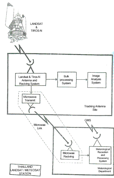
Figure 1. Block diagram of Thailand Landsat/Meteorsat Station Expected to be operatonal in late 1981
Although Thailand has been using multiband aerial photography and air-borne multispectral scanner data for several years, the first large scale multiband aerial photography project was initiated in 1979 with partial assistance from UNDP. A four-band camera on board the air-craft took photos of the watershed areas in Northern Thailand during the flyng season in 1979-80 and the imagery are being interpreted by user agencies with the aim of developing a better scheme for the management of agricultural/forest land use in the watershed areas. The project would take three years to complete. Already the impacts of this new technology is being observed. Plans to intensify the efforts and to expand the area of study are being considered.
Proposed Asian Cooperative Program in Remote Sensing
Remote sensing is a technology suited for cooperation among countries in a given region because it is multidisciplinary in nature and the satellite can cover a large geographical area. Moreover, basic infrastructure in most developing countries exists such that this new technology can Remote sensing can provide valuable and timely information to assist and to complement other data in the planning, development and management of natural resources and in monitoring environmental changes. Asian countries should benefit from this new technology and the best way is by means of close cooperation among us in the areas of information exchange, dissemination of data, joint research projects, and exchange of technical personnel. Some of the proposals are outlined below:
- The Asian Conference on Remote Sensing should be held once a year with Japan acting as the secretariat and the venue of the meeting being rotated among Asian countries.
- Thailand Landsat/Meteosat Ground Receiving Station would provide services to Asian countries within the coverage area in an efficient and timely manner.
- The Asian Regional Remote Sensing Training Center at the Asian Institute of Technology should be utilized by Asian countries to train remote sensing specialists to meet the requirement of each country.
Background information on remote sensing activities in Thailand and some discussion on present plans have been presented. The investigations conducted by Thailand using Landsat data confirmed the results of similar investigations elsewhere about the benefits of satellite remote sensing for assessment of natural resources and for monitoring of environmental changes which were vital to resources inventory, planning and management at the national level. Research and development in several disciplinary areas led to a more refined study in a wider range of applications on the one hand, and quasioperational projects on the other. Since practical applications hae been demonstrated in agriculture, forestry, land use, geology and oceanography; expanded activities in utilizing satellite remote sensing data have taken place. With the availability of regular and timely data from the resource satellites, many existing investigations and research projecsts could become operational. Thailand looks forward to a closer cooperation among Asian countries in the remote sensing field and offers her facilities and resources for international collaborations.