| GISdevelopment.net ---> AARS ---> ACRS 1980 ---> Technical Session |
An Integrated Approach To The
Remote Sensing Of Subtromic Mountain Area in South-Western China.
Chen
Shub-peng
Institute of Remote Sensing Application, Academia Sinica
Institute of Remote Sensing Application, Academia Sinica
History and Development
The Tropic of Cancer cuts through the Yunnan-Guizhou plateau and the Guangxi basic in South-Western China. There are many river valleys and intermountain basins with the appearance of subtropic and tropical landscape in the area.
In the early 1950’s black-and-white (panchromatic) aerial photogrammetry was very well made in the south-west provinces in out country, followed by the interpretation of airphotos, inventories and series mapping were made with regard to the land use and forest resources in the subtropic and tropic regions. We also studied the possibility of analyzing tropical rainforest phases, searched for some nooks in the hills where the raids on cold wave and typhoons might be avoided and ascertained the upper limit for developing rubber and other tropic economic paints. Interpreting and mapping were made of the geodynamic evidence of the non-tectonic movement in the mountainous regions, such as active faults, landslips and mud-rock flow. In conjuction with survey of high mountain glaciers, many famous high mountains, including the Qomolangma, were measured and mapped by terrestrial photogrammetry. An estimate was made of water source from snow-cover and melted glacier. This preliminary work opened the prologue of remote sensing studies in the area.
In the 1970’s with new remote sensing data provide by weather satellities and other scientific experiment satellities, we update the old maps, e.g. we acquired new knowledge of the river head of Huanghe and Cother scientific experiment sateallities, we upd number of lakes increased from 500 to 800. Estimates of forest area have also been revised. Moreover, many geologists and geographers have been organized to conduct lineament analysis and geological mapping. It has been proved in practice that it was possible to save 40% manpower and material and speed up the rate by 2-10 times. New progresses have been made in study of tectonic and engineering geology analysis of earth-quack background and prediction of mine-forming belts.
In recent years, the Chinese Academy of Sciences through self-reliance has been developing airborne remote sensors, organizing aerial remote sensing experiments, from black and white, infrared to multi-band, from single-discipline to multidiscipline applications. Among them the infrared detecting of an underground river in the karst mountain regions, exploitation of hot spring resources in the granite mountain region, the selection of railway line from the point of engineering geology and general survey of resources of Teng-Chong, Yunnan, in all these initial economical technique benefit has been derived.
The special natural environment of the subtropic mountainous region in the south-western part of our country presents some special problems in relation to remote sensing techniques.
- It is necessary to utilize various remote sensing methods and
complex pre-processing technique of digital images.
Because of longitudinal deep valley combined with latitudinal physiographical belt the selection of the high solar angle in remote sensing season and shadow confine is very strict, and geometrical distortion and flight height is very complicated. - The widespread karst phenomena on the residuum combine the pseudo-karst relief features taken the form of the red rock series to form very delicate image pattern. Because the ground is covered with thick forests of evergreen broad-leaf vegetation, it is necessary to make the match analysis for the image on both multi-band and side-looking radar.
- The difficulties in transporation result in unbalanced resource exploitation and land use. Experience has proved that starting with use of satellities remote sensing data for thematic mapping, partly aided with airborne remote and mapping, it is possible to save manpower and material with timely replacement when necessary.
A Sample Study and its Primacy Analysis
In the western part of Yunnan province, in the subtropical mountain regions on the upper reaches of Lancang-jiang and Irrauddy My, we have conducted a multi-target environmental remote sensing experiment, from which the remote sensing data are already obtained, including:
- Four kinds of aerial photos. They included panchromatic, infrared, color and color infrared photos with two different scales of 1:34000 and 1:16000. Its format was 230 by 230 mm;
- Multispectral phtotographic images obtained by the multispectral camera with four bands : 0.4-0.5, 0.5-0.6, 0.6-0.7, >0.7µm and effective format 57 by 57 mm. The scale of the images was 1:52,000;
- Multispectral data tapes and images obtained by multispectral scanner with nine channels: 0.40-0.44, 0.44-0.49, 0.49-0.55, 0.55-0.64, 0.64-0.80, 0.80-1.10, 1.10-1.80, 3-5 and 8-14µm, and swath width of 90, IFOV 3mrd.
- Thermal infrared data tapes and images obtained by infrared scanner
with six channels: 8.0-8.9, 9.1-10.1, 10.3-11.4, 11.6-12.8, 13.0-14.0,
and 2-14µm. Its swath width was 60°, IFOV 2.6 mrad, and temperature
resolution 0.2 K. Spectral survey of some objects from helicopter and on
the ground (fig. 1). The spectroradiometer used in the survey can
measure spectroradiance with bands from 0.4 to 1.1µm. The spectral
resolution is 2-3% of the wavelength, focus length 280 mm and field of
view 2°. Its recording unit was a three pen functional recorder.
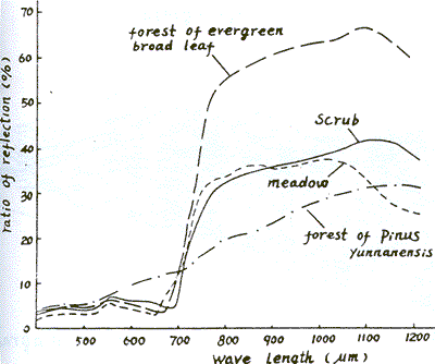
Fig. 1 The Spectrum reflection of land cover in Teng-Chorg mountain region (after Teng. C.X. et al 1978)
Primary analysis of Landsat CCT and terrain digital medelling (Fig. 2). The sampling interval of modeling was 250 by 250m.
Hypsograph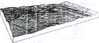
Fig. 2 The terrain digital model of Teng-chong Mountain region (after Chang-gin et al. 1979)
Ground truth and thematic mapping. There were 25 kinds of maps about natural environmental elements and natural resource evaluation. The scales of the maps are 1:100,000 and 1:200,000 respectively. The sensors and film used in the experiment were all developed in China except the RC-10 metric camera. The intergraduated interpretation and analysis of the above remote sensing data were concentrated on three main aspects:
Research on Lineament and Ground-water Resource
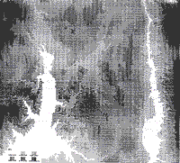
Through analysis remote sensing data and extracting information from terrain digital modeling (Fig.3), we have already obtained some useful results, for example, based on thermal infrared image of band 10.3-11.4µm at 5.00-7.00 A.M., we can find a lot of springs and the other water bodies. In such cases over 90% of large well and /or springs (including warm and hot spring) and more than 70% of water-gushing bore holes were interpreted correctly. In addition, we can directly interprete alluvial-diluvial fans, marshland and water bearing structural zones. In this way we have comprehensively verified and delineated four water-bearing systems.
Based on aerial photos, we can define the type of rocks, identify structural phenomena and analyse landforms and their evolution. Research showed that the main part of surface runoff (about 65% of total runoff) came from the ground-water runoff in granite and basalt areas. The lava flow filled the old valley and led to the change of river course and shift of ground water drainage divide. It also changed the estimate of water balance.
It was very clearly shown that the distribution of hot springs and volcanoes was controlled by faults, which can be divided into three zones: west, central and east ones. There were 19 volcanoes or hot springs controlled by NNW fault zone in the west zone. On the other hand, they were distributed along S-N faults in the central and east zones.
Analysis of lineament is in many respects of obvious significance for exploiting resources in the mountain regions. First, as is well known, the west-south mountain regions of China, like the neighboring countries of Burma and Malaysia, is a part of important multimetal minerogenetic zone and a producing area of high tenor iron one. The analysis of minerogenetic role and position by means of lineament should aid the discovery of new deposits and to increase the reserve . Second, there are a lot of fault and downcast mountain basins which are filled by sediment of river and lake, the analysis of lineament should aid the discovery of blinded faults and to stimting the toner of pear and the other deposites. Third, the west-south part of China is just located at the intersection between the Himalayas range and the Pacific Ocean seismic belts. Lineament analysis should aid the study of the background of seismic geology and investigation of seismic situation. Fourth, the lineament analysis is of great significance for production in engineering geology. It’s very useful in many respects, such as the design of dams and bridges, the choice of railway line and construction of archway in bridges and tunnels, etc., in which it is used to study the reservoir, karst underground river.
Research on Multispectral Remote Sensing and Land Covers
In the subtropical mountain regions, ecological environment is complex, reproducible resources are affluent. Applying the slicing color adding and digital techniques to variant remote sensing images, such as panchromatic and multispectral images, etc., we can synthetically analysis the imagery spatial and spectral characteristics of some objects and phenomena. Furthermore , we can deduce the conditions of soil development or forest ecology; divide them into different types or classes, and carry out the thematic mapping such as the map of soil, forest, vegetation and land use, etc.
For example, in order to choose the optimum bands which are perfectly adapted to the research on landscape and soil science, the random sampling network of 150 by 150 m was arranged in the experiment site. Using model-302 field spectroradiometer, 115 spectral curves of land covers which have wavelength rang 04µ to 0.9 µ and were divided into 7 bands (Fig. 4). Meanwhile, the various types of images were analysed and compared . The results show that the bands of 0.6-0.7µ and 0.7-0.8µ are better than the other ones. Landsat MSS-5 and color infrared imagery show the most imformation in the several images, and they are interpreted easy; when B-W infrared and panchromatic images are analysed together various types of land cover can be distinguished, and whn panchromatic images are only used, its effects are passable, too. In addition, using principal component analysis, there are four kinds of land types to be distinguished obviously on the two dimensional plane, which are waste grass land, bare land, wheat fields and paddy fields (Fig. 5). As another example, at the beginning of the 50’s , we started to estimate timber volume using airphotos in China. Recently, it has been established that the quantitative table of timber volume used to Landsat MSS image in south very height mountain area Xi-Zang plateau, through setting up the regress equation between environmental index and ecological factors such as slope, direction of position of the slope, and altitude above sea level etc., It is shown that there is correlation between height of trees and the other factors, such as geology, geomorphology and artificial effects in the subtropic mountain regions, with relative low altitude and small difference of altitude.
There are 162 sample fields in Teng-chong site, which included pointed tree of 100 fields (Pinus Yunnaneniss, Pinus armandii and their mixing forest). There is an obvious posive correlation between timber volume and three chromatic elements (hue, saturation and brightness). The coefficient of multiple correlation is 0.823. owing to the influence of shadow, it is not a simple linear relationship and sometimes the anomalous phenomena may occur. The coefficient of multiple correlation between color infrared image and timer volume is higher than that between B-W image and timber volume in the sample areas with pine leaf trees. Correspondingly , the former is 0.902, the latter is 0.709. As contrasted with the above effects, there is a negative correlation between timber storages and chromatic elements of color infrared image in the study slops of the sample areas with broad leaf trees (Fig. 6).
Fig 6 is not avilable
Discussion on Space Information and Landscape Texture
The special features of southwest subtropical mountain regions in our country are three-dimentional landscape texture, namely, the influence of latitudinal zonality, monsoon function and sea-level elevation, which are closely interacting factor. The great height above sea-level and relative relief have transformed the moderately changeable latitudinal natural zonality into multiseries vertical natural zonality. Adding the barrier function of the mountain monsoon eliminate extraordinary enhanced the difference of vertical zonality.
Among the mountain gorges in the southwest part of our country, the tropic, sub-tropic , temperate and annual snow over landscape all appeared in the distance of several decakilometer.
It is very important to investigate these types of subtropic mountain region vertical landscape and its hot island in the fields of ecological environment and tropical crop development.
Ecological environment information provided by remote sensing images processes the features of synthesis, summary and dominance. With this, it is possible to analyzing their relationship and investigate the restarting effect on primary productivity. It was just the synthetic reflection of ecological environment that could interpret visually the distribution of outline and features of different ecological elements.
We proceeded to conduct experimental work on delineating the types of landscape texture, establishing the ecological system of four-order landscape differentiation family tree and constracting their space model.
As for the southwest monsoon, Mt. Gaoligong has its obvious climatic barrier function, foehn effect temperature inversion phenomena are so evident the vertical zonal pattern of natural vegetation. On both the east and west slops the difference appears especially clear. The low valley of Nu-jing River to its east is dry and hot and the low valley of Liang-He River to its west is wet and hot. The tropic plants left economic crops. Among these are hevea brasili ensis, musa paradisiacal, saccharum sinensis, and so on.
It is of great significance to analyze ecological environment and landscape texture for remote sensing research in subtropical mountains regions.
- The transport is difficult and regional development assumes the appearance of natural economy in these areas. The grades of politico-economic divisions are obviously suited to the landscape units. Usually, the administration boundaries tally with the watershed of small river basins. The governments of countries and people’s communes are centered in the intermountain basins. These have greatly facilitates establishing geographical information system and geographical measure analysis. It has a direct bearing on the vertical zonal pattern about agricultural disposition, economic crop development and the gathering and processing of state-owned products in the mountainous regions. Even the life-style and manner of production of the national minorities in compact communities evidently reflect the influences of the ecological environment and degree of the economic development.
- Dividing Land Pattens on the Basis of Landscape Units Further considering similar leading factors and transformation channels, we have draw up the forest environmental index and evaluate the land potential level.
- The compare of multidate remote sensing images will be enhanced when we have grasped the ecological regularity and seasonal phase changes.
Discussions and Prospects.
It is of great scientific and international significance to study the subtropical mountainous regions in southwest China, where the application of aerial and satellite remote sensing is urgently needed and has a broad prospect in the future.
- Giant arcs of mountain ranges and ribbon-like islands constitute the geological basis for the natural environment of the Asia continent, stringing many counties together in that region. The macro study of many geoscientific problems, such as the Quaternary volcanoes, geothermal belts, earthquake belts, tin ore belts and other multi-metal ore belts requires the advanced application of Landsat images as well as higher resolution aerial remote sensing.
- Many international rivers in southeast Asia originate from the mountains regions in southwest China, flowing from the Qinghai-Xizang plateau, the roof of the world, into the Indian Ocean and the western Pacific Ocean, wherein lies the world’s cleanest source of hydroenergy while widely related to many countries in respect of irrigation, flood control navigation planning and development. The study of glacier and snow cover, estimation of runoff, forecasting of flood, all urgently require remote sensing monitoring.
- Land covering in the subtropical mountainous regions is abundant and variegated, with stereotyped interlocking of many regions, showing in the short distance between of southern foothills of the Himalaya mountainous a panoramic view of the world’s physiographic zone. On the one hand, reproductive resources are abundant and primary production is potentially high, while a general survey by remote sensing is needed where resources are not ascertained. On the other hand, there is serious destruction of ecological balance requiring, as it does, remote sensing to be used for monitoring and for management production.
- It is one of the regions in Asia where it is most difficult to apply
remote sensing technique. It is necessary to further improve the
technology of remote sensing. For instance, the study of tropical rain
forests and the land covering of the weathered red crust requires high
resolution side-looking radar. The tropical rain forest of Hainan Island
have five-layer tree crest, and the thickness is 30 meters, while
weathered red granite crust sometimes reach 40 meters. The
Trans-himalaya mountainous regions are deep valley, relative relief is
up to 700m/km, all forming shadows on the Landsat images and aerial
photos. So it is necessary to select new bands and optimum seasonal
period for remote sensing.
The matching analysis of Landsat images and digital topographical model, also has great value for application in this region. And the solution of these problems will be a new contribution to the development of international remote sensing technique. - The density of population distribution and economic exploitation are quite unbalanced geographicallyt in this region. In the intermountain basins and valley plains, houses are closely stacked , canals and rivers crisscrossed, rice fields widespread, agriculture very intensive, as is diametrically opposed to the ecology of remote mountainous regions with their spare population, difficult transport, inaccessible mountains and ancient forests, slippery slopes and avlanches. In these places it is much more difficult to apply remote sensing technique to manage or estimate agricultural production than in the great plains, and the environmental factors and regional differences to be taken into consideration are much more complex. Final solution is possible only after long-term international cooperation.