| GISdevelopment.net ---> AARS ---> ACRS 1980 ---> Technical Session |
Geomophological Studies Of
Bangladesh Cost Using Landsat Data.
M.A.H.
Pramanik
Director
Bangladesh Space Research and Remote Sensing Organization
Director
Bangladesh Space Research and Remote Sensing Organization
Abstract
The present describes salient features of the geomorphological changes of Bangladesh Coast based on computer and visual analysis of Landsat data for the periods 1972/73, 1976/77 and 1979. This study has identified the places for newly accreted land, erosion and changes in the river courses over time. In addition, this study will provide recommendations for undertaking artificial techniques like construction of cross dams, afforestation, etc. for consolidation of newly accreted land and minimizing /stopping erosion, etc. with a view to overall development of the coastal area of Bangladesh.
Introduction
Bangladesh is located in the world’s largest delta, formed by the Ganges, Brahmaputra and Meghna Rivers. The terrain is flat and interlaced with an intricate system of rivers and tidal channels. Vast quantity of suspended sediment resulting from surface runoff and bank erosion is carried downstream by these rivers and channels to the Bay of Bengal, where much of it apparently settles down to form new land. Frequently, however, tidal action re-suspends large amounts of this sediment while in the Bay and then redistributes it along the coastline. As a result, gains in land in one area may be offset by losses in another. Thus, it needs further studies to ascertain net changes in tha land along the coastline of Bangladesh and also to study the processes involved.
Based on the available information on the geomorphological conditions and hydrological features, Bangladesh coastal area may be broadly divided into three regions:-
- The western region starting from Tetulia river to the western border to Bangladesh (Hariabhanga river), which the Sunderban is situated , is relatively not very active in terms of formation of new land. Due to the presence of the deep forest area, river bank erosion is less and rivers are deeper. Formation of new land is not prominent except at some places near the shore. Sediment load does not accumulate much in the Bay area due to presence of the Swatch of no Ground which starts few miles south of Hiron point at the mouth of the Pussur River.
- The Eastern region starting from Tetulia river to Chittagong coast area is very active in terms of sediment load distribution. Most of the activities of sedimentation and erosion are occurring in this region. This dynamic region is relatively shallow and the rivers and channels change their courses rapidly.
- The Central region starting from the confluence of the Padma and Meghna utto Santirhat in Bhola is active in terms of river bank erosion and sedimentation or formation of ‘Char’ area in the river courses, which also changes. These sediment load carried by the rivers and being redistributed in the Eastern region as mentioned above
Computer analysis of Landsat data for the time period 1972/72, 1976/77and 1979 was carried out using Amdhal 470 computer of the University of Michigan under a joint research project of Bangladesh Space Research and Remote Sensing Organization (SPARRSO) with the Environmental Research Institute of Michigan (ERIM) under UNDP/FAO sponsorship. The computer analysis was supplemented by aerial photographs and Ground observations.
Methodology of Data Processing:
The following Landsat data/CCT were selected after reviewing the cloud cover, data quality and tidal stage. Unfortunately all low tide-condition CCTs were not available from EROS data center.
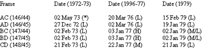
Tidal condition not known. The CCT was not available for comparison with 1976 data.
L = Low tide, M= Medium, H = High tide.
In order to accomplish the change detection task it was necessary to be able to reliably discriminate between water and several categories of land. Following four candidate algorithms were selected as being likely methods for/effectively classifying the Landsat data.
- Level slicing of MSS 7
- Level slicing of an MSS5/MSS7 ratio
- An MSS 5 and 7 look-up table
- Maximum likelihood ratio multispectral pattern recognition.
In the ratio the results are better in terms of reducing the omission error for both submerged land and vegetated land.
The MSS look-up table approach produced the best results of any of the techniques we tried in terms of both statistics and actual pixel classification. Note that the look-up table permitted mapping sand, which neither MSS 7 threshold or the ratio could accomplish.
The pattern recognition approach in terms of pixel classification accuracy surprisingly compared very unfavourably with the similar techniques. Although vegetation and sand were correctly mapped, submerged land and water were considerably confused. This is partly due to the fact that the signatures used to classify the data were derived from clustering. Since turbid water and submerged land are spectrally similar, it is logical that a cluster signature would be formed describing this overlapping distribution of data values. A signature derived in such a fashion would be unable to distinguish between turbid water and submerged land at least part of the time as appears to be more sensitive to the noise content of the data, as witnessed by the “striping” effect where submerged land erroneously appears in water.
Another factor which strongly works against the pattern recognition technique is cost. It requires four to seven times more computer time to implement the four-channel pattern recognition algorithm compared to the other techniques considered. As a result of this comparison the MSS 5-7 look-up table was selected t classify the accretion take data. It represented the best tradeoff between accuracy and cost.
It should be pointed cut that we were not completely successful in finding a technique that could universally distinguish between very turbid water and submerged land. The reason for this is that, even though not much radation penetrates water in the 0.8-1.1 mm region, there is enough penetration so that very high turbidity can still affect the volume reflectance of water. The result is very turbid water becomes spectrally indistinguishable from sand bars and mud flats. Future sensors could make an unambiguous separation of land and water possible by having a near-infrared band located beyond 1.5 microns, the point at which penetration of water below the surface by near infrared radiation is negligible.
Steps of Processing:
- Conversions of Landsat CCT received from the digital format used at EROS Data Centre (Sioux Falls, SD. USA) into a special ERIM Format called MSS. The version of MSS Format used is a streamlined version compatible with ERIM software and has one byte per data value, channel interleaving and one record per scan line.
- Taking four individual CCT’s representing the four quarter of a Landsat Frame into single File by the Programme ‘ABUT’. At the end of the abutting procedure, each frame was stored on a single tape in a file containing 2340 scan-lines and 3240 (Landsat 1) or 3264 (Landsat 2 & 3) points.
- The raw Four Channel multispectral data for each observation of a given area was classified using a MSS 5 and MSS 7 look-up Table and a single channel output Tape generated for each frame for each date. A look-up table is an array of numbers stored in the memory of a computer. These numbers represent different scene classes. The axes of the array represent the signal levels in different spectral bands detected by the sensor. In essence, a look-up table permits classifying raw spectral data by retrieval rather than computation. During classification raw spectral data is used as address (set of coordinate in the array) in the computer’s memory and the scene class (number) found there is assigned to the resolution element which provided the spectral data. This technique is very valuable because it potentially has nearly the same power as most computational pattern recognition, and yet requires substantially less processing time.
- The data from the two observations of a given area were merged into a two channel file (tape) for each frame. This step was to merge the data from the two observations of a given area into a two channel file (tape) for each frame. Channel 1 contained the classified data for 1976-77. To merge the data from the different observations we used the programme REGISTER. This program performs a linear transformation on the line point numbers of one data set so that when finished they match thea other data set for a given geographical location. The transformation is derived from a least-square fit regression calculation based on the line and point numbers of control points from each data set. A control point is a geographical location that has been positively identified and accurately located in both data sets. Once the transformation is calculated, the program steps through data set one, calculates the nearest whole pixel from data set two, and merges this pixel as an additional channel to the first data set.
- The next major step in the processing flow of the accretion Task consisted of comparing the Landsat classifications of a given Geographical location of two observation dates and detecting whether or not, a change occurred between two dates and if so, what kind. This change detection was implemented using a program called CMMPARE.
- The program DESKEW was used to make linear corrections to the Landsat data to remove the effects of earth rotation during data collection that caused a skewing in the location of pixels in successive scanlines in reference to their true ground location. The SCALE option in the deskewing program was then used to resample the data within each scan line and produce a new output file in which enough pixels are retained to make a map at the desired scale. The actual number of the pixels per scanline uses is a function of the minimum spot size of the display device. The pixels that are chosen for use in the re-sampling are selected on the basis of being the nearest neighbour to the coordinates calculated by the resampling algorithm.
- Two sets of maps were produced using two different concise display devices. Working maps were generated using the ink jet printer associated with ERIM’s MIDAS computer. The ink jet printer is a useful device for quickly printing hard copy of digital data and directly accepting MSS format data. Displays are made on sheets of 8-1/2”XII” paper which can store images 864 pixels wide and 1314 pixels long. Minimum spot size of the display system is 0.0080 “Long and 0.0085” wide. Colors are produced by additive combinations of 3 dyes (red, yellow, and blue). In their basic form these dyes are water soluable, and these maps have to be coated with a plastic resin to make them durable. A copy of all the products required for this project was made on the ink jet printer.
- The other display device used in this project is one operated by
ERIM’s Resources Data Center (ERDC). This display device is an optronics
PI500 Drum film recorder. Maps made by the ERDC are enlarged prints of a
color negative that is generated by photographically combining there
black and white separations. Each of these separations controls one of
the emulsion layers of the color negative and is produced by varying the
intensity of a pinpoint beam of light striking the spinning drum. The
intensity of the light is controlled by a computer according to the
classification of a pixel. The density of the image for each black and
white separation is proportional to the amount of light that should be
let through the emulsion layer of the color negative it controls in
order to form, in combination with the light let through the other
emulsion layers, the color assigned to the classification it represents.
The Physical colour maps (1:500, 000) have four principal categories.
- Water
- Sand and clouds
- Non-vegetative land and
- Vegetative land.
- Unchanged land
- Unchanged water
- Land Accreted - Land eroded/tidal coverage.
The computer processing of Landsat data was performed for quantitative assessment of the land accretion in the Bangladesh coast. A detailed analysis by computer of 35,678 square miles of Bangladesh was performed on Landsat data for the two of the area from the concerned agencies and to undertake pilot projects taking into account the following factors:- Accretion of land could be speeded up near the existing landmass by suitable technique (afforestation, cross-dams etc.)
- The whole coastal area will have to be considered in totality so that a project in any place does not have adverse effect on any other place.
In addition following actions are proposed:-
- Historical development and changes of the coastal area are to be studied thoroughly.
- Potential area of immediate reclamation is the Southern part of Hatiya island. Cross-Dam joining Hatiya and Nijhum Dwip may accelerate acceretion. Provision of necessary drainage system for monsoon water and tidal water should be made.
- Effective steps may be taken for stopping erosion in the Northern and Eastern parts of Bhola, northern and western parts of Hatiya island and Sendwip. The erosion may be reduced by dredging out stray ‘Chars’ in the river mouths.
- New accreted land may be put under afforestation for consolidation. The areas identified are located in the southern and eastern part of Hatiya, char lakhi and char Elahi area, Feni river estury and South of Sandwip.
- Data for current, depth, turbidity, didal fluctutions etc. will have to be collected and correlated. Oceangraphic charts are to be prepared.
- Aerial photographs will have to be taken at both high tide and low tide conditions and maps are to be prepared.
- Continuous monitoring of the dynamic processes in the area will have to be undertaken.
Completion of computer analysis of 1979 CCT data will throw much light in the dynamic processes of the coastal morphology of Bangladesh.