| GISdevelopment.net ---> AARS ---> ACRS 1980 ---> Technical Session |
Direct Reception and Data
Processing of Meteorological Satellites Tiros-N/NOAA-6
Mikio Takagi, Yoshiaki
kudo, Yoshio Ishido, Hiromasa Tanaka
Hiroshi Sato, Akira Kobori, Naohiko Ohkuma
Institute of Industrial Science, University of Tokyo
7-22-1, Roppongi, Minato-ku, Tokyo 106, Japan
Hiroshi Sato, Akira Kobori, Naohiko Ohkuma
Institute of Industrial Science, University of Tokyo
7-22-1, Roppongi, Minato-ku, Tokyo 106, Japan
Introduction
Meteorological satellites have a long history and have made a remarkable advance in development and practical use. There are two types, geostationary and polar orbital meteorological satellites and the observations have been made according to the features of orbits. The polar for the acquistion of high resolution images in visible and infrature regions, the measurement of vertical atomospheric temperature profile, the monitoring of space environment, and locating the position of fixed or moving platforms and obtaining environmental data from them. These satellites broadcast the data on their path and the data can be easily received.
We have been engaged in the research on the utilization of meteorological satellites (NOAA) through digital image processing (1) (2) (3) . The data has been supplied by the Japan Radio Co., Ltd. And the Meteorlogical Satellite Center in the form of raw analong tapes or raw digital CCT’s. Therefore, we have had some difficulties in getting data for semi-real time analysis and sequential image data analysis. The direct reception of the data from satellites has been highly desirable for our research and the effort to build a ground station for the NOAA series satellites and data processing system has been carried on. Here, our data reception and processing system is introduced.
Outline of NOAA Series Satellites (4) (5)
Tiros-N and Noaa-6, which are operational, are the third generation NOAA series satellites. TIROS-N and NOAA-6 were launched October, 1978 and June, 1979, respectively. This series will continue until 1985 and the satellities up to NOAA-G (or H and I) are expected to be launched. All observed data are transmitted in digital form except for APT (Automatic Picture Transmission), in which image data re transmitted in analog form.
1 Orbit
The NOAA-6 is in a sun synchronous and nearly circular polar retrograde orbit. Its average altitude is 814 km and its orbital period is approximately 101 minutes. The orbital data is sent from NOAA and broadcast through JMG (SW) channel by the Meteorlogical Agency in Japan. The data consists of six orbital parameters and the information on the nominal orbit over Washington such as the time and longitude crossing the equator, and the altitude, latitude, and longitude of every two minutes.
2 Instruments
The following instruments for observation are on board.
a. Advanced very High Resolution Radiometer (AVHRR)
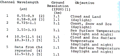
The advanced Very High Resolution Radiometer is an advanced type of VHRR (Very High Resolution Radiometer) of the former NOAA series and this radiometer has five channels in visible and infrared regions as shown in Table 1.
b. TIROS Operational vertical Sounder (TOVS)
TOVS consists of HIRS (High Resolution Infrared Radiation Sounder), SSU (Staratospheric Sounding Unit), and MSU (Microwave Sounding Unit). HIRS has 20 channel filters from 0.7 mm to 15 mm and measures the temperature from the earth surface to 10mb, the humidity and 03 divided in three layers with the resolution total of 20 mk and the swath width of +49.50. SSU has sensitivity in 15 mm and measure of CO2 with the resolution of 147 km and the swath width of +400 MSU is a microwave radiometer and measures the temperature up to 20 mb using the absorption of 02 at 53 GHz with the resolution of 100 km and the swath width of 47.350.
C. Space Environment Monitor (SEM)
SEM is composed of TED (Total Energy Detector), Meped (Medium Energy Proton and Electron Detector), and Hepad (High Energy Proton and Alpha Detector) measures the flux of the sun proton, electron and alpha particles.
D. Data Collection and Location System (DCLS)
DCLS collects the data such as temperature, pressure, wave height and so forth from platforms on the ocean and locates a platform measuring the Doppler shift when the satellite passes over the platform.
3 Data Communication system
Various instrumentation data and satellite telemetry data are multiplexed and transmitted to the earth in real-time through the following data transmission systems as shown in Figure 1.
a. High Resolution Picture Transmission (HRPT)
All instrumentation data and telemetry data are multiplexed and transmitted at 1700 MHz band by PCM-PM. Table 2 & 3 show the transmissin characteristics and HRPT parameters.
b. Automatic Picture Transmission (APT)
Two channels are selected from AVHRR and the image resolution is converted to approximately 4 km to match the standard facsimile of 120 lines/minute. The data is transmitted at 137 MHz by AM-FM.
c. Direct Sounder Broadcast (DSB)
TOVS, SEM, DCLS, and telemetry data are multiplexed and transmitted at 136 MHz by PCM-PM.
d. Direct Sounder Broadcast (DSB)
TOVS, SEM, DCLS, and telemetry data are multiplexed and transmitted at 136 HMz by PCM-PM.
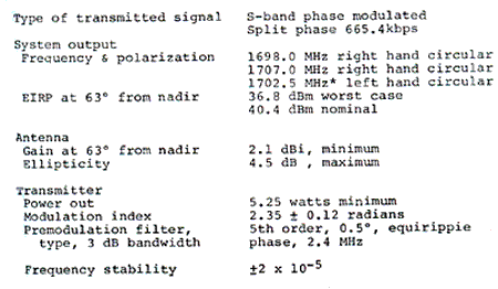
Figure 1 TIROS-N/NOAA real-time systems data flow
Table 3 HRPT Parameters
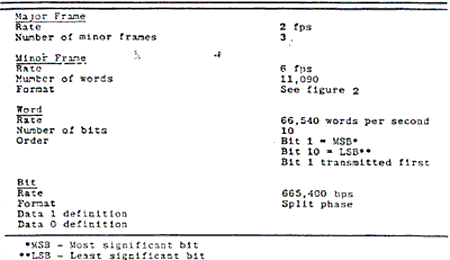
Figure 2 HRPT minor frame format.
Figure 3 TIROS-N/NOAA Receiving and processing system block diagram.
Direct reception and data processing system for TIROS-N/NOAA-6
1 Outline of system
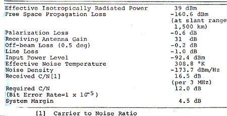
A system to receive HRPT data is under development at our laboratory. This system is also designed to receive and process the data from other satellites such as NIMBUS-7 and GMS with a little modification. Figure 3 shows the blcok diagram of the system and Table 4 shows HRPT L-band link summary.
The antenna is controlled through a nominal trajectory by command from a computer and receives HRPT at 1700 MHz. HRPT video signal (665.4 kbps) is recored on a data recorder after the clock extraction and demodulation by the bit synchronizer. Any one channel of AVHRR is selected and displayed on a tehermal printer for real time monitoring. After the tracking, the data recorder is reproduced and HRPT data is sent to the data processing system.
The image processing system with a minicomputer at the Multi-dimensional Image Processing Center is used for data processing and analysis.
Processing of telemetry data, calibration of each sensor, geometric transformation (mapping) and so on are in the category of data processing. To shorten the time required for geometric transformation, which needs a rather long time with a minicomputer, a special purpose processor is under development.
As for data analysis sea surface temperature mapping, vertical atomospheric temperature profile, detection of change extraction of drifting ice and so forth are under planning.
Table 4. Tiros-N/NOAA HRPT L-band Link Summary
2 Design and Characteristics of each subsystem
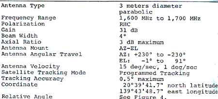
1 Antenna
For the reception of HRPT data a 3 meters diameter azimuth-elevation mount antenna was installed at the top of the main building of our institute. The antenna has two control modes: manual mode and computer controlled mode by programmed tracking subsystem. Table 5 shows the antenna subsystem specification. The receiving antenna pattern is shown in Figure 4 and the reference points of this antenna are shown in figure 5.
2 Programmed tracking subsystem
This subsystem sends the azimuth and elevation pointing data to the antenna subsystem in real time to acquire and track the satellite. The azimuth and elevation data are calculated at the interval of one second before tracking and at the time of tracking these data re interval of one second before tracking and at the time of tracking these data re interpolated at the interval of 0.1 second and sent to the antenna. The calculation of orbit from the orbital information, control data generation, and the management of the control and tracking of the antenna are the mission of this subsystem.
- Orbit calculation: The orbit is calculated based of the data from information receiver to be mentioned below. The model in which the earth is assumed as the rotated ellipsoid, is used to reduce the error in tracking.
- Generation of control data: The data at the interval of one second acquired by the orbit calculation are converted into the angle information of the antenna and stored. Since the azimuth-elevation mount antenna used in this system has the limitation of 900 in elevation, the azimuth angle is controlled at the high speed mode to prevent at lack of data when the satellite passes the zinith.
- Correction of programmed tracking: This system is based on the programmed tracking, however, the utilization of the received signal to improve the accuracy of tracking is under consideration.
- Time code generatior: The time code generator is provided for real-time tracking.
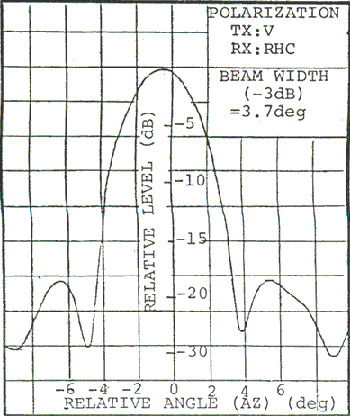
Figure 4. Receiveing Antenna Pattern
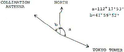
Figure 5. Relative angle between receivng antenna and reference targets
3 Orbital information receiver
The preliminary information on the orbit is mandatory for the tracking of a satellite. The orbital information is supplied by NOAA and broadcast around 4 a.m. by JMG at the frequency of 7.402 MHz or 3.670 MHz with 5 kw transmiting power by F1 modulation. This signal is demodulated by the phase lock method and a microprocessor converts its teletype code into ASCII code.
4 Receiver
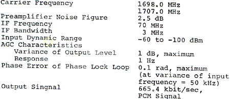
Phase-modulated HRPT signal at 1700 MHz band is demodulated and the baseband modulated PCM video signal is detected. The high frequency amplifier and frequency converter are put on the antenna mount to lower the noise. The phase detector detects the intermediate frequency signal at 70 MHz synchronously with the reference signal. The main specifications of the receiver are shown in Table 6.
5 Demodulator
The bit synchronizer regenerates the clock of 665.4 kHz and demodulates the split phase signal into the baseband PCM video signal. The frame synchronizer detects the 6 word sync pattern in the HRPT format and extracts the clock signals at the frame rate and word rate. Also, the frame synchronizer is designed so as to select an arbitrary channel for quick look monitoring and to transfer the data to the image processing system.
In the detection of sync pattern three stages, search, check and lock stages, are provided.
The number of allowable errors in sync pattern is adjusted at each stage so as to optimize the sync acquisition time and sync holding time.
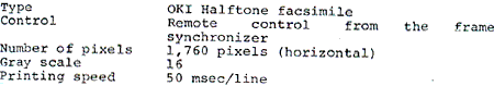
6 Quick look monitor
A thermal printer is provided for quick look monitoring of an arbitrary channel selected by the frame synchronizer. The output part of a facsimile machine is modified into this graphic printer, the capability of which is shown below.
7 Data recorder
At the time of tracking the split phase PCM video signal is recorded on this data recorder, which can record the data for twelve minutes with a 7200 ft magnetic tapes.
8 Data processing
8.1 Hardware
The hardware of this subsystem consists of the minicomputer based image processing system at the Mult- idimensional Image Processing Center, system at the line, and Geometric Interpolation Unit (GIU). As shown in Figure 6, the data is transmitted via data transmission line from our laboratory in the main building to the Multi-dimensional Image Processing center in the annex.
Data transmission and data input
· AVHRR data from the satellite is recorded on a data recorder in real-time. It is reproduced at 1/8 speed of recording and through the bit synchronizer and frame synchronizer the data is sent at the rate of 8.3 kword/sec (10 bit/word) to the computer. The specification of Hewlett packard’s standard I/O interface. The input data is recorded on a 800 BPI magnetic tape. The data volume of one orbit is 48 MW/sec at maximum.
The software for direct recording of the data on a magnetic disc without playback of the data recorder is also under development.
· Geometric Interpolation Unit
via a DMA channel to and from the computer. With this unit the processing time can be shortened drastically compared to the computation by software. This unit is a special purpose processer and developed to shorten the time required for geometric transformation with a minicomputer. The main function is the four point interpolation and this unit has 512x512x8 bit frame memory. The data and parameters are transferred
8.2 Software
The flow of our satellite image processing is shown in figure 7. Each program is stored on the disc as a file and operates under the operating system of the minicomputer (Real Time Exective System RTE). By inputting a necessary command from the disc onto the main memory and executed.
· HARPT data input
According to the data format of HRPT, the data is recorded on a 800 BPI magnetic tape in a record unit of 10 bit/word, 1848 word/record, deleting the frame sync pattern and adding the record number. The orbital information is also added for the geometric transformation.
· Processing of telemetry data
From the telemetry data included in HRPT the necessary parameters for the calibration of each sensor are calculated. The calibration of each image sensor in infrared channel is based on the space brightness level, which is zero, and the internal calibration lamp at the temperature of 150 C and the parameters G and I for the calibration formula shown below are calculated.
N = GX=I (1)
Where N is the observed brightness level, G is the channel gain, x is the observed value, and I is the channel bias. This processing is applied to the infrared channels and parameters and calculated as the average of successive five lines.
· Caliration of sensors
As for the visible channels the brightness level is calculated by (1) using the calibration parameters before launch supplied by NASA. And using the parameters calculated by the telemetry data processing calibration is made for infrared channels.
· Geometric trasformation
In geometric transformation four point interpolation method is used to save the time for computation, although it is desirable to calculate on the point by point basis. In this method the map plane is divided into blcok with a certain size. The calculation of the coordinate transformatio is done only at four corner points, and the position of each point except for these four points is calculated by the interpolation of these four points. Since this processing takes a long time, if processed by software, the Geometric Interpolation Unit has been designed to speed up this processing. The final result is mapped by the Mercator’s map with latitudal, longitudal, and costal lines.
· Sea surface temperature calculation
The sea surface temperature is calculated from the brightness level of infrared channel. From the formula between brightness and temperature, the conversion table from brightness to temperature is generated beforehand and the brightness of each picture element is converted into temperature referring to this table. After the elimination of clouds and land by thresholding in brightness level, the sea surface can be extracted and the sea surface temperature is calculated. Further advanced techniques should be developed for, correcting the effects due to the atomospheric attenuation, and sea surface wave.
· Vertical temperature profile
From TOVS data the atomospheric temperature profile from the earth up to the height of 10 mb is calculated with this processing. Software for image analysis, such as the extraction of drifting ice, detection of the temporal changes and so on, has been under development. An interactive image processing software system named CSY2 (6) has been provided for general purpose image processing. Using this software system, various kinds of processing such as histogram generation, edge detection, contrast enhancement and so forth, can be easily applied to the NOAA data.
Conclusion
The system for direct reception and processing of data from TIROS-N/NOAA satellites is introduced here. This system is under construction and it is expected that all subsystems are connected at the end of October. Before the operation many problems might be solved. The urgent problems are as follows: First, it is necessary to assure the accuracy of tracking of the satellite and to confirm the received data quality.
Second, the effectiveness of the Geometric Interpolation Unit should be confirmed. The further development of image processing software package is still going on and the utilization techniques of the received data shall be developed with the cooperation with the users in various fileds.
Acknowledgements
Acknowledgement due to many people for their cooperation with us in the development of this system. The authors wish to express his gratitude for the guidance and encouragement received from Prof. One and the members of the Multi-dimensional Image Processing Center, for the arrangements in the transfer of the antenna received from Prof. Nomura, Director of the Institute of Space and Aeronautical Science, University of Tokyo, Mr. Ichikawa of ISAS, and the members of ISAS and IIS offices, for the considerations in the installment of the antenna received from the members of the building and repairs committee and the members of the facilities division of IIS, for the helpful assistance in desighing the antenna system received from Dr. Hasebe, for the kind support in the survey of the antenna position received from the members of Prof. Murai’s laboratory, and for the valuable arrangement in renting the measuring equipment received from Prof. Hamazaki’s laboratory.
They also wish to express their thanks to Mr. Takahashi, Head of the Ground Equipment Development Group, NASDA, for his kind considerations to the use of the data recorder, to Mr. Narui, the Chief of the Meteorological Satellite Section the Meteorological Satellite Center, for offiering the orbital information and data, to Dr. Nakaya of Oki Electric Co. for his offer of the theremal printer, to Mr. Kurashige, Executive Director, and his members of Meisei Electric Co., who carried out much work in the adjustment of the antenna, the design and manufacturing of the receiver.
References
- M. Takagi, K Tamura: “Simple Input Equipment for Meteoroloical Statellite Images and its Application” Proceedings of the National Convention of the Institute of Television Engineers of Japan, 11-5, July, 1975.
- M. Takagi, K. Tamura: “Digital Processing of Meteorological Satellite (NOAA) Images”, Journal of the Institute of Television Engineers of Japan, Vol. 31, No. 5, PP, 408-415, May, 1975.
- M. Takagi, K. Tamura: “Measurement of sea surface Temperature from the Meteorological Satellite (NOAA) Images,”, Proceedings of the Society of Photo-optical Instrumentation Engineers, Vol. 155, pp. 169 – 175, August, 1978.
- A. Schwalb: “The TIROS-N/NOAA A-G Satellite Series”, NOAA Technical Memorandum NESS 95, March, 1978.
- L. Lauritson, G.J. Nelson, F.W. Porto: “Data Extraction and Calibration of TIROS-N/NOAA Radiometers”, NOAA Technical Memorandum NESS 107, November, 1979.
- M. Takagi, K. Sakaue: “An Interactive Image Processing Software System of a Minicomputer” Record of the Technical Group on Inage Technology of the Institute of Japan, IE-63, December, 1977.