| GISdevelopment.net ---> AARS ---> ACRS 1980 ---> Technical Session |
Detection of Volcanic Ash
Fall Area from Landsat MSS CCT Data -Eruption of Mt. Ontake in 1979
Shinkichi
Kishi
Information of Processing Laboratory
National Research Center for Disaster Preventation Science and Technolgoy Agency
3-1 Tennodai, Sakura-mura, Niihari-gun
AbstractInformation of Processing Laboratory
National Research Center for Disaster Preventation Science and Technolgoy Agency
3-1 Tennodai, Sakura-mura, Niihari-gun
A dormant volcano, Mt. Ontake, Located in the central part of Japanese mainland, erupted unexpectedly in Oct. 1979, and the villages at the foot of the mountain suffered from the volcanic ash fall.
The paper describes a study of the digital analyses to detect the volcanic ash fall area, using two Landsat MSS imageries taken a few days before and after the eruption.
From the fact that the study area was almost covered by vegetation and the eruption took place in late autumn, it became a problem to distinguish the variation caused by the ash fall from the variation caused by the seasonal degeneration of vegetation.
Through the study it was found that the difference value of Band 4 and those of Band 7 most contributed to the detection of ash fall area in the seasonal degeneration of vegetation, and an area covered by estimated 1 mm or more thick ash fall was successfully detected.
Introduction
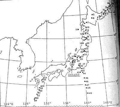
In the early morning of Oct. 28 1979, Mt. Ontake (35º 53' 24"N, 137º 29' 00"E, 306m) erupted unexpectedly, which had been recognized as one of 77 active volcanoes in Japan (Fig. 7) and had been dormant for more than 10 thousand years.
Volcanic smoke from the main crater about 30m in diameter opened near the summit and form about 10 crater lets adjacent to it reached the altitude of about 4,000 meters. The ash fall riding on the west-southwest wind scattered in the direction of east-northeast centering on the two villages on mountain foot. It was sighted even in several local cities about 150 km distant.
Fortunately the eruption ceased in day, and since then, with only white volcanic smoke rising, it has maintained quiet vicissitude.
At the time of this eruption, Landsat-3 on Oct. 23 and Landsat-2 on Nov. 1 caught the wide area of Mt. Ontake and its surrounding area in ‘Takayama’ scene (path 117, row 35) in their MSS imageries.
Promptly, National Space Development Agency of Japan (NASDA) officially published the composed color photographs of above two days. Because of the fact that color tone of the assumed ash fall area was delicately changing, interest was centered in the detection of the range of fallout of volcanic ejecta such as volcanic ash by digital analyses.
National Research Center for Disaster Prevention (NRCDP), along with the field survey, conducted the analysis of MSS CCT data at the two times mentioned above. Block diagram of the image processing system developed by NRCDP is shown in Fig. 8.

Fig . 8 Image Processing System in NRCDP
As clarified by the field survey, the amount of ash fall was smaller compared with that of Mt. Usu’s eruption in 1977, it was considered advantageous to use both imageries before and after the eruption, then to use the single imagery of post-eruption.
However, the eruption coincided with the autumnal season of crimson leaf color, it was necessitated to distinguish the variation in those two times caused either by ash fall or seasonal change of vegetation.
After normalization of brightness of two imageries and geographic correction, the spectral radiant characteristics (reflected solar radiation) of CCT data at several sports were calculated. Thus, using only the data of essential bands Band 4 (0.5-0.6 µm) , ash fall area was extracted from the difference image of the two times.
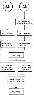
Fig. 1 shows the outline of the processing.
Normalization of brightness of two imageries.
As for the slight difference in brightness of imageries originated in the difference of sensitivities of MSS sensors of the two satellites, the digital values on CCT of Landsat-2 MSS were normalized to those of Landsat-3 MSS by the following equations, derived from the adjustment of the values in gain or dynamic range measured before launching.
Here in the following equations, V2 and V3 denote the digital values recorded on CCT and suffixes 2 and 3 indicate satellite number.
Band 4 : V3 = 1.037 V2 + 2.1
Band 5 : V3 = 0.863 V2 + 1.9
Band 6 : V3 = 0.901 V2 + 2.4
Band 7 : V3 = 0.850 V2 + 2.3
Geographic correction using ground control points
Range for analysis was set in equal size to the topographic map on a scale of 1 to 50, 000 published by Geographical Survey Institute of Japan (about 22.5 Km x 18.5 Km), centering around the two villages on mountainfoot.
Imageries at the two times, before and after the eruption, were resampled and rearranged depending upon the coordinates system of longitude and latitude for the practical purpose of dropping the ash fall area on the map, and a method to overlay two images directly each other was not used.
Taking into account the circumstances of computer programming and the objective of analysis, rearranged mesh size was set equal to the size of dividing side and length of the '1 to 50,000 topographic map' into 200 equal parts, i.e. 4.5" in longitude and 3.0" in latitude.
This mesh size is about 100 meters square and the pixel in the bulk-processed CCT is about 50 meters square, therefore rearrangement was conducted by using the average of four neighborhood pixels (Fig.2)
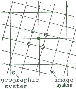
Fig . 2 Resapmling
Coordinates transformation from image system to geographic system was conducted by following linear formula (After transformation), which possess the function of parallel transformation, rotation and expansion and contraction.
X = a U + b V + c
Y = c U + d V + e
Here, U, V denote the image coordinates, while X,Y denote the geographic coordinates. Coefficients in the transformation formula were determined by least square method, with the coordinates of ground control points (GCP) for each system.
Coordinates of GCP were input from the image on CRT by cursor and from the topographic map by XY digitizer. Though it was not easy to select suitable points for GCP because of the mountaneous study area, about 10 point, such as the junction of rivers , dam sites and featured parts of mountains, were selected for GCP, so that they were distributed evenly in the area.
Least square residual errors between the coordinates of GCP on the image and those on the ' 1 to 50,000 topographic map', were within 40 meters, for each image.
Spectral radiant characteristics of the data of imageries at some representative sports.
According to the qualitative consideration of the spectral radiant characteristics of main objectives in the two times, before and after eruption, following aspects would be mentioned.
That is, Band 4 and Band 5 are lightened and Band 7 is darkened by ash fall as an inorganic substance. On the other hand, the radiant intensity moves to Band 5 from Band 4, corresponding to the color change of vegetation from green to red via yellow, and Band 7 becomes dark by the degeneration of vegetation such as defoliation.
It was necessary to grasp quantitatively those tendencies in order to extract as fall area from the difference imagery between the two times.
So that, selecting total about 30 sports, from ash fall or non ash fall area for each class of several kinds of land cover, in and around the analyzing area, CCT counts were examined.
Here, the selection of ash fall or non ash fall spot was made based upon the field survey, aerial photographs and the materials of the villages office.
Size of the spot was set equal to 2 x 2 meshes after rearrangement (about 200 meters square. Equal to 4 x 4 pixels in the original imagery) and the CCT counts signify the average of the spot
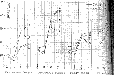
Spectral radiant characteristics of representative spots among these spots are shown in Fig. 3
Positions of the spots are marked in Fig. 5.
From Fig. 3 the following particulars might be stated.
- The values of Band 4 increase and the values of Band 7 decrease at ash fall spots except bare land.
- As for the degree of the variation , considering the quantity of fallen ashes estimated at these spots , the larger the quantity of fallen ashes, the larger the variation is found.
- Though the values of Band 7 decrease even at non ash fall spots, the degree of decrease at ash fall spots is extremely large.
- Band 5 and Band 6 show the tendencies similar to Band 4 and Band 7 respectively. But the tendencies of the former are not so conspicuous as those of the latter.
- The increase of the values of Band 5 at non ash fall spot in the deciduous forest must be the result of the color change of leaves.
- Here is no factor which increases the values of Band 4 except ash fall.
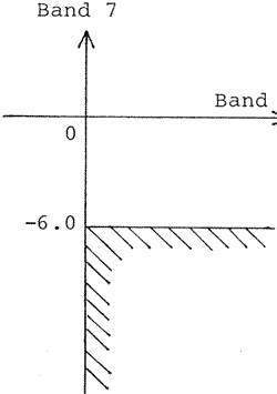
Fig . 4 shows a domain for ash fall discrimination in the difference plane produced by subtracting the data before eruption from those after eruption as for these essential Bands.
On reference to. Fig . 3,setting up the numerical condition for discrimination, positive for Band 4 and less than –6.0 (CCT counts) for Band 7, the ash fall area was extracted from the difference images.
Now, about the bare land, the values of Band 4 and Band 5 slightly decrease by ash fall, because of their originally strong radiance in the shorter spectral region.
Accordingly ash fallen bare land is not included in the domain for discrimination stated above.
However, there is little bare land in the analyzing area except the summit part of Mt. Ontake, and because the summit part was covered by cloud or snow alternately at the two times, little area could be analyzed even if ash fall were sought.
In addition the original objective was to detect the ash fall distribution in broad perspective using the data from satellite.
Therefore, bare land was excluded from the analysis.
Detection of ash fall area from the difference image and mapping.
Next, retrieving the meshes in the analyzing area which satisfy the condition for ash all discrimination, set from the examination of spectral characteristics and consisting of Band 4 and Band 7, the results were printed on general purpose curve plotter along with display on CRT . (Photo. 2)
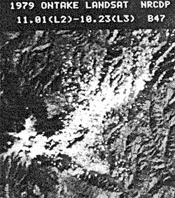
Photo.2 display of ashfall area (white colored area)
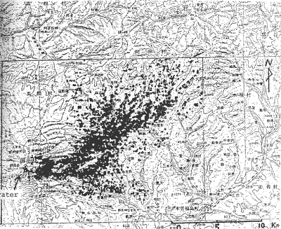
Fig. 6 Mapping of ashfall area (balck dotted area)
Fig. 6 shows the ash fall area on the '1 to 200,000 geographical map'. This figure was obtained as follows.
The figure printed by curve plotter with ink pen was copied on OHP paper using XEROX copying machine, and then overlaying it on the '1 to 200,000 geographical map', they were copied again.
The ash fall area in this figure (black dotted parts) was extracted from the difference images of Band 4 and Band 7 smoothed before hand by moving average of 2 x 2 meshes.
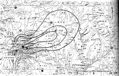
Comparing the result with the distribution map of ash fall by the village office in Fig. 5, it is found that the result is appropriate on the whole.
Contours in Fig. 5 express the degree of ash fall divided roughly into three grades. The outer line seems to be corresponding to the contour of ash fall o 1 – 5 mm thickness.
On the other hand, the Landsates detected ash fall area in southeast direction of Mt. Ontake. On Nov. 1, the day Landsat-2 was passing through, white volcanic smoke was flowing in the direction of east-southeast and it was feared that the smoke was taken for fallen ashes in the analysis.
However, from the fact that in the variation of the spectral characteristics of the smoke Band 4 is lightened largely and Band 7 is lightened slightly, too, it is considered that the smoke itself would not be confused with the fallen ashes.
Conclusion
In the area covered by the vegetation at autumnal leaf color changing season, the detection of the ash fall area by volcanic eruption can be made from the differences of the values of Band 4 and of Band 7 of Landsat MSS data taken before and after the eruption.
The limit of detection is estimated to be about 1 mm or more of ash fall thickness, from the surveys after the eruption such as interpretation of aerial photographs, etc.
Future problems
In the paper the threshold values, which could discriminate ash fall area from non ash fall area, was sought in the values of variation.
If the values of variation in the two times are quantitatively related to the amount of fallen ashes, it may be possible to pusue the quantitative distribution, too.
For that, it will be necessary to make land cover classification of analyzing area and by each category, the variation caused by ash fall will have to be detected.
Ash fall by this eruption brought about damages on farm crops, fish ponds, etc. from the viewpoint of volcanic disaster prevention by means of remote sensing, studies should be directed concerning the method of estimation of disaster on the land use by volcanic ejecta such as ash fall.
Reference
- S. Kishi : Application of Aircraft Remote Sensing to the Survey of Volcanic Eruption Disaster-Eruption of Mt. Usu in 1977-; Technical Forum on Remote Sensing and Surveying Technolgy, JARS, Nov. 1978.
- S. Kishi : Remote Sensing for Disaster Prevention; Text of Seminar on Technology for Disaster Prevention, Vol. 3, NRCDP & JICA, Oct. 1979.
- S. Uehara, S. Kishi, et al.: Report on the Field Survey of the Eruption of Mt. Ontake in 1979; Survey of Main Disasters, No. 16, NRCDP, (in Japanese) Mar. 1980.